‘Catastrophic’ flooding possible in California as Hilary moves north


MARK ABRAMSON/THE NEW YORK TIMES
Lifeguards at the 72nd Place Lifeguard Station in Long Beach, Calif., today, help residents and community members by filling up sandbags and distributing them ahead of Hurricane Hilary’s arrival to Southern California.

NOAA VIA ASSOCIATED PRESS
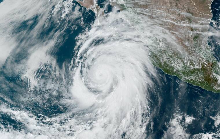
This satellite image taken at 6:50 am Hawaii time, today, and provided by the National Oceanic and Atmospheric Administration (NOAA) shows Hurricane Hilary off the Pacific coast of Mexico.


Hurricane Hilary, a large and powerful Category 4 storm, was this afternoon barreling toward the Baja California peninsula and the Southwestern United States, where it may cause “life-threatening and potentially catastrophic flooding,” meteorologists said.
The National Hurricane Center issued its first-ever tropical storm watch for Southern California, including downtown Los Angeles, today.
A watch means that tropical conditions are possible within the area over the next 48 hours. The watch stretches from the California-Mexico border to the Orange County and Los Angeles County line and for Catalina Island, forecasters said.
The system had sustained winds near 130 mph, according to the National Hurricane Center. Tropical disturbances that have sustained winds of 39 mph earn a name. Once winds reach 74 mph, a storm becomes a hurricane, and, at 111 mph, it becomes a major hurricane.
Hilary formed as a tropical storm off the coast of Manzanillo, Mexico, on Wednesday and began moving west-northwest toward Baja California as it strengthened.
Although the storm’s intensity was expected to fluctuate throughout this evening, it will weaken but remain a hurricane as it approaches the west coast of the Baja California peninsula Saturday.
Don't miss out on what's happening!
Stay in touch with breaking news, as it happens, conveniently in your email inbox. It's FREE!
Hilary will then probably become a tropical storm before reaching Southern California by Sunday night.
Hilary’s exact landfall probably will not make much of a difference when it comes to the expected hazards in the region, meteorologists said.
Hilary will bring up to 6 inches of rain, with isolated amounts up to 10 inches, across portions of the Baja California peninsula through Sunday night, with the possibility of flash flooding.
Portions of Southern California and southern Nevada will record similar rainfall totals through Tuesday morning, which could lead to “dangerous and locally catastrophic flooding,” forecasters said.
A flood watch was issued for Los Angeles and Ventura counties, including Catalina Island. Other areas across the West can expect a few inches of rain.
Forecasters said strong winds would occur ahead of the storm’s center.
Mexico’s government issued a hurricane warning for the Baja California peninsula from Punta Abreojos to Cabo San Quintin. A hurricane watch was also in effect for the Baja California peninsula’s west coast north of Cabo San Quintin to Ensenada.
A tropical storm warning and watch were also issued for multiple regions of the peninsula and mainland Mexico.
The Eastern Pacific hurricane season has been active this summer, but most of these recent storms have tracked west toward Hawaii, including Hurricane Dora, which helped enhance extreme winds that led to the devastating wildfires on Maui.
It is “exceedingly rare” for a tropical storm to come off the ocean and make landfall in California, said Stefanie Sullivan, a forecaster with the National Weather Service in San Diego. The only tropical cyclone to truly make landfall in Southern California was an unnamed storm in 1939 that made landfall in Long Beach, she said.
However, storms have come close or weakened before coming ashore, still causing flooding and dangerous winds, like Kay, a post-tropical cyclone, last year. Sometimes storms even move across the state from Mexico; in 1997, Hurricane Nora made landfall in Baja California before moving inland and reaching Arizona as a tropical storm.
Hurricane season in the Eastern Pacific began on May 15, two weeks before the Atlantic season started. The seasons run until Nov. 30.
Complicating things in the Pacific this year is the development of El Nino, the intermittent, large-scale weather pattern that can have wide-ranging effects on weather around the world.
An average Eastern Pacific hurricane season has 15 named storms, eight hurricanes and four major hurricanes. The Central Pacific typically has four or five named storms that develop or move across the basin annually.
There is solid consensus among scientists that hurricanes are becoming more powerful because of climate change. Although there might not be more named storms overall, the likelihood of major hurricanes is increasing.
Climate change is also affecting the amount of rain that storms can produce. In a warming world, the air can hold more moisture, which means a named storm can hold and produce more rainfall, as Hurricane Harvey did in Texas in 2017, when some areas received more than 40 inches of rain in less than 48 hours.
Researchers have also found that storms have slowed down over the past few decades.
When a storm slows down over water, it increases the amount of moisture it can absorb. When the storm slows over land, it increases the amount of rain that falls over a single location, as with Hurricane Dorian in 2019, which slowed to a crawl over the northwestern Bahamas, resulting in 22.84 inches of rain at Hope Town over the storm’s duration.
These are just a few ways that climate change is most likely affecting these storms. Research shows there may be other impacts as well, including storm surge, rapid intensification and a broader reach of tropical systems.
This article originally appeared in The New York Times.
© 2023 The New York Times Company


