Hawaii is in for an unpredictable hurricane season

COURTESY JESSICA HENRICKS
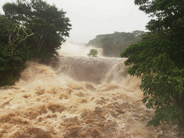
Hurricane Lane’s torrential rain had the Wailuku River raging last month in Hilo. “What was strange about Lane was how sharp of a turn it took, almost a 90-degree turn,” said Alison Nugent, an assistant professor of atmospheric sciences at the University of Hawaii. “Lane slowed down and then it turned. It’s not that it’s never happened, but it’s rare.”
It’s shaping up to be an unpredictable hurricane season in Hawaii, with cyclones approaching from multiple directions — and there’s still six weeks left until it comes to a close on Nov. 30.
Tropical Storm Olivia made history Wednesday by becoming the first storm to make a direct hit on Maui in modern times.
Olivia came in from the east at a higher latitude than most storms. The east, or windward side, has long been considered Maui’s less protected side. To the south, west and north, Maui has the Big Island, Lanai, Kahoolawe and Molokai standing in the way of approaching storms.
Other tropical storms have been known to approach the state from the east at higher latitudes — Hurricanes Madeline and Lester did just that in 2016 — but none had made landfall on Maui, said National Weather Service forecaster Matt Foster.
Asked if there is a precedent, Foster said, “As far as the era of having historical records on hand, no. But probably in the historical past it probably has happened.”
The directions hurricanes take rely on weather patterns that can push them into different paths. Hurricane Lane was on a path toward Oahu, but broke apart before making landfall.
Don't miss out on what's happening!
Stay in touch with breaking news, as it happens, conveniently in your email inbox. It's FREE!
Many hurricanes follow a familiar route that takes them south of Hawaii island and then farther west.
But Lane suddenly turned right and up the leeward sides of the islands, just like Hurricane Iniki in 1992 before it devastated Kauai.
“What was strange about Lane was how sharp of a turn it took, almost a 90-degree turn,” said Alison Nugent, an assistant professor of atmospheric sciences at the University of Hawaii. “Lane slowed down and then it turned. It’s not that it’s never happened, but it’s rare.”
This year, Hurricane Hector followed a path far south of Hawaii island. Hurricanes Miriam and Norman never made it that far and both turned right and northeast long before reaching the islands.
“Storms are steered by high and low pressure systems,” Nugent said. “The track is more dependent on the atmospheric environment and the intensity is more dependent on the sea surface temperature.”
As alarming as this season has been, Hawaii has seen more volatile hurricane seasons as recently as 2015.
The 2015 hurricane season was “the year that never ended, it seemed,” said John Bravender, warning coordination meteorologist for the Central Pacific Hurricane Center. “It was a record- setting hurricane season with 16 tropical cyclones, the highest we’ve ever had. It was a very warm year, very humid, with warm waters.”
The 2015 hurricane season was so long it spilled into January 2016 with Hurricane Pali, which blew in with winds of 100 mph before it took an unusual, southerly route toward the equator and fell apart.
Like 2015, this year Hawaii is expected to experience an El Nino winter with warm waters providing fuel to drive hurricanes.
Ocean temperatures around the islands are already 2 to 3 degrees above normal, pushing into the upper 70s, Bravender said.
In May, the National Weather Service predicted three to six tropical cyclones, with equal 40 percent chances of an above-normal and near-normal season and a 20 percent chance of a below- normal season.
A near-normal season has three to five tropical cyclones and an above-normal season would have six or more cyclones, which include tropical depressions, named storms and hurricanes.
Right now, Bravender said, “Olivia is the fifth tropical cyclone. We’re in an above-normal pattern.”
As Olivia passes, Hawaii can expect a break from the threat of another hurricane, Bravender said.
“Right now there’s nothing approaching the Central Pacific over the next week,” Bravender said.
But in the next breath, he warned residents and visitors to be prepared.
Especially with an El Nino year approaching, Bravender said, “We can and have gotten hurricanes outside of the normal hurricane seasons. When ocean waters are above normal, we can have an active hurricane season — and a longer one as well.”


