Madeline bears down on Big Isle; Maui County under tropical storm warning
NATIONAL HURRICANE CENTER
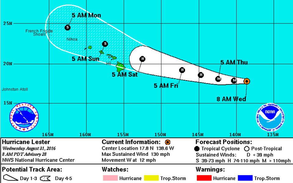
This graphic shows the projected path and intensity of Hurricane Lester as of 5 a.m. today.
CENTRAL PACIFIC HURRICANE CENTER
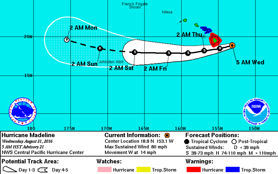
This graphic shows the projected path and intensity of Hurricane Madeline as of 5 a.m. today.
NOAA/ NASA/ GOES WEST
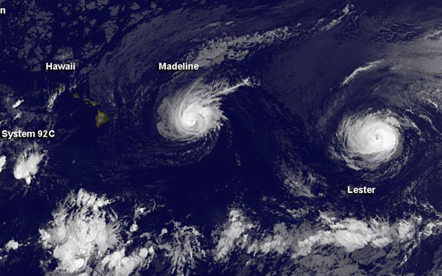
This composite satellite image shows hurricanes Madeline and Lester heading to Hawaii. A low pressure system south of Hawaii is not expected to intensify, but could cause tradewinds to increase today.


» View Hurricane Lester’s track Opens in a new tab
Update Wednesday 7:45 a.m.
The east side of Hawaii island is under a flood advisory this morning as the outer bands of rain from Hurricane Madeline begin to reach the island.
The National Weather issued the advisory until 10:15 am after “radar and rain gauges indicated heavy rain associated with the outer bands of Hurricane Madeline over the South Hilo and Puna districts. Rain was falling at a rate of 1 to 2 inches per hour. Additional rainfall is expected to move over the eastern slopes of the Big Island through the day.”
Forecasters said the advisory includes Hilo, Hawaiian Paradise Park, Keaau, Pahoa, Pepeekeo, Glenwood, Hawaiian Acres, Mountain View, Papaikou, Volcano, Hawaii Volcanoes National Park and Orchidland Estates.
The entire island is under a flash flood watch through Thursday as Madeline approaches from the east.
Don't miss out on what's happening!
Stay in touch with breaking news, as it happens, conveniently in your email inbox. It's FREE!
Update Wednesday 5 a.m.
Madeline weakened overnight, barely maintaining its hurricane status but still posing a dangerous threat to the Big Island.
At 5 a.m., the hurricane had maximum sustained winds of 80 mph with higher gusts and was centered about 140 miles east-southeast of Hilo and 355 miles east-southeast of Honolulu. Madeline was moving west at 14 mph.
Hurricane-force winds extend outward up to 10 miles from the center and tropical storm-force winds extend up to 125 miles, according to the Central Pacific Hurricane Center.
• Hawaii island residents stock up, board up Opens in a new tab
• List of Madeline shelters, closures and cancellations Opens in a new tab
• What you need to know to prepare for a storm Opens in a new tab
A hurricane warning is in effect for Hawaii island, and a tropical storm warning was issued for Maui County this morning. A high surf warning has been issued for eastern shores of Maui, while a high surf advisory for eastern shores of the other islands remains.
Madeline’s forecast track has it moving just south of the Big Island, but close enough to bring heavy rain, damaging winds, and dangerous surf starting today. It is expected to travel well south of the other islands.
Churning further east in the Pacific, Hurricane Lester maintained its Category 4 status with maximum sustained winds of 130 mph, moving west at 12 mph. It was 1,085 miles east of Hilo at 5 a.m., and is expected to cross into the Central Pacific later today. The storm’s forecast track brings it just north of the islands starting this weekend.
Hurricane-force winds extend out up to 35 miles from the center and tropical storm-force winds extend up to 90 miles, according to the National Hurricane Center.
Update 11 p.m.
Hurricane Madeline has weakened to a Category 1 storm, but remained a significant and immediate threat to the Big Island. It was about 235 miles east of Hilo and 440 miles east-southeast of Honolulu by 11 p.m. Tuesday.
>> All Big Island public schools, UH campuses closing
>> Lava viewing area, parks, ports closing in advance of storm
>> What you need to know to prepare for a storm
>> White House monitoring Hurricane Madeline but Obama’s trip still on
Maximum sustained winds dropped to 90 mph but Madeline increased in speed as it continues to move west at 12 mph. Hurricane-force winds extend out up to 25 miles from the center and tropical storm-force winds extend outward up to 125 miles.
A hurricane warning and flash flood watch are in effect for Hawaii island, and a tropical storm watch has been posted for Maui, Molokai, Lanai and Kahoolawe.
The latest forecast track has Madeline glancing South Point on the Big Island, but a direct hit on the island is still possible. No matter its eventual exact path, forecasters and government officials warn that Madeline is likely to pack a dangerous punch of wind, rain and surf.
Central Pacific Hurricane Center forecasters on Oahu said the threat includes hurricane-force winds of 75 mph or more for the Big Island as early as late Wednesday and into early Thursday; tropical storm-force winds of 40 mph or more over Maui County late Wednesday into early Thursday; surf building from east to west across the Hawaiian islands, possibly becoming damaging along eastern shores of Hawaii island and Maui Wednesday into Thursday; heavy rain of 5 to 10 inches across Hawaii County, with isolated maximum amounts near 15 inches, especially over windward portions; rainfall totaling 1 to 3 inches, with isolated maximum amounts up to 4 inches, across Maui County; and the possible combination of storm surge and tides causing flooding, with water reaching 1 to 3 feet above ground.
East of Madeline, Hurricane Lester remained a reinvigorated and powerful Category 4 storm, centered about 1,260 miles east of Hilo and moving west at 12 mph, with maximum sustained winds of 140 mph and higher gusts. The latest forecast track has it skirting just north, and within striking distance, of the entire island chain this weekend.
Hurricane-force winds extend out up to 35 miles from the center and tropical storm-force winds extend out up to 90 miles, according to the National Hurricane Center in Miami. The storm is expected to enter the Central Pacific Wednesday as a major hurricane. While it is expected to weaken after that, forecasters still believe it will be a hurricane as it approaches the islands.
“Interests in Hawaii should monitor the progress of this hurricane,” they said late Tuesday.
Update 8 p.m.
Hurricane Madeline weakened to a category 1 storm about 270 miles east of Hilo and 475 miles east-southeast of Honolulu tonight.
Maximum sustained winds dropped to 95 mph as the storm traveled west at 10 mph.
Hurricane-force winds extend 25 miles from the center and tropical storm-force winds go out 125 miles from the center.
The storm is expected to gradually weaken and turn to the west-southwest sometime tonight, which should send it just south of South Point early Thursday morning.
It should still be at hurricane strength when it makes its closest pass to Hawaii island.
Hawaii County remains under a hurricane warning and Maui County is under a tropical storm watch.
Update 5 p.m.
Hurricane Madeline retained its strength and direction this afternoon. It remained a category 2 hurricane with 110 mph winds heading west on a path toward Hawaii island at 10 mph.
At 5 p.m., the storm was 315 miles east of Hilo and 510 miles east-southeast of Honolulu. Hurricane-force winds extend 25 miles from the center and tropical storm-force winds extend 125 miles from the center.
The storm is expected to gradually weaken and turn to the west-southwest sometime tonight, which should send it just south of South Point Wednesday.
It should still be at hurricane strength when it makes its closest pass to Hawaii island.
Hawaii County remains under a hurricane warning and Maui County is under a tropical storm watch.
East of Madeline, Lester Opens in a new tabre-intensified into a powerful category 4 hurricane with maximum sustained winds of 140 mph, moving west at 13 mph.
The storm was 1,225 miles east of Hilo and could bring strong winds and rains to the state over Labor Day weekend.
Lester is expected to turn slightly to the west-northwest as it crosses into the Central Pacific over the next two days.
Hurricane-force winds extend 35 miles from the center and tropical storm-force winds go out 90 miles from the center.
Update 4 p.m.
Gov. David Ige issued an emergency proclamation this afternoon in advance of possible landfall of hurricanes Madeline and Lester
The proclamation authorizes state spending for relief of disaster-related damages, losses and suffering resulting from the storms, according to Ige’s office.
“As always, our top priority is protecting the health, safety and overall welfare of our residents and visitors. During this time, I ask residents and visitors to closely follow emergency instructions as we prepare for the storm. I urge you to take immediate steps to protect your families, loved ones, employees and property. The state is monitoring the storms and standing by to support the counties,” Ige said in a news release
The disaster emergency relief period starts today and continues through Sept. 9.
Update 2 p.m.
Hurricane Madeline weakened to a Category 2 storm, but still maintained sustained maximum winds of 110 mph, about 350 miles east of Hilo and 540 miles east-southeast of Honolulu.
Madeline is still traveling west at 10 mph.
Forecasters are watching for a shift in Madeline’s direction to the west-southwest over the next 12 hours. That slight change in direction should take the storm just south, but still “dangerously close,” to Hawaii island on Wednesday, the Central Pacific Hurricane Center said. Gradual weakening is also expected over the next 48 hours.
At 2 p.m., hurricane-force winds extended outward up to 25 miles from Madeline’s center and tropical storm-force winds extend up to 125 miles.
Update 1:05 p.m.
The National Weather Service estimates there is a 90 percent chance of tropical storm conditions and winds greater than 39 mph for South Point, a 78 percent chance in Hilo and 68 percent chance in Kailua Kona.
The likelihood of hurricane-force winds is 10 percent in Hilo, 6 percent in Kailua Kona and 23 percent in South Point, the National Weather Service estimated after the 11 a.m. Hurricane Madeline update.
Honolulu has a 17 percent chance of experiencing tropical storm-force winds. Kahului’s chances are estimated at 26 percent and Lihue has an 11 percent likelihood of seeing sustained strong winds.
Update 12:23 p.m.
Hawaii County Civil Defense issued a message urging residents to prepare for hurricane-force winds and heavy rains:
“Hurricane force winds are expected over Hawaii County sometime Wednesday into early Thursday.
“Ocean swells generated by Madeline are expected to build from east to west across the Hawaiian Islands today and tonight, possibly becoming damaging along east facing shores of the Big Island.
“Heavy rains associated with Madeline may reach Hawaii County on Wednesday with greatest amounts over windward areas. This rainfall may lead to dangerous flash floods and mudslides.
“In preparation for Hurricane Madeline, the public is advised to be StormReady.
“Build or restock your emergency preparedness kit. Include a flashlight with fresh batteries, cash, first aid supplies, and any medication or supplies specific to you or your family members.
“Plan how to communicate with family members. Create an evacuation plan for your household. Bring in or secure outdoor furniture and other items that could blow away. Keep your vehicle fueled and cell phone charged.
“To help preserve water availability through the storm, the Department of Water Supply asks customers to minimize non-essential use of water, such as irrigation.
“Find more StormReady tips and sign up for notifications at hawaiicounty.gov Opens in a new tab.”
Update: Tuesday 11 a.m.
The National Weather Service issued a hurricane warning for the Big Island late this morning as Madeline barreled west toward the state, packing maximum sustained winds of 115 mph.
At 11 a.m., Madeline, a Category 3 major hurricane, was 370 miles east of Hilo and moving west at 10 mph. Hurricane-force winds extend outward up to 25 miles from Madeline’s center and tropical storm-force winds extend up to 125 miles.
The warning, meaning hurricane conditions are expected in the next 36 hours, adds to a slew of other watches and warnings for the islands as Madeline approaches.
Hurricane Madeline is forecast to pass just south of the Big Island as a weakened hurricane, however the southern half of the island is in the track’s so-called “cone of uncertainty,” meaning a direct hit is still possible.
“This track will take the center of Madeline dangerously close to the Big Island of Hawaii late Wednesday and Thursday,” said forecasters from the Central Pacific Hurricane Center on Oahu.
They say the public can expect hurricane-force winds of 74 mph or more over the Big Island late Wednesday into Thursday, while tropical storm-force winds of 39 mph or more are possible for Maui County at that time. Surf from Madeline is expected to build across the islands today, starting with east-facing shores of the Big Island and Maui County.
Heavy rain should hit the Big Island Wednesday and is possible for the other islands later Wednesday through Thursday. “Madeline is expected to produce total rain accumulations of 5 to 10 inches, with isolated maximum amounts near 15 inches, across the Big Island, especially over windward portions.This rainfall may lead to dangerous flash floods and mudslides,” forecasters said. “Madeline may produce up to 4 inches of rainfall across Maui County.”
In the Eastern Pacific, Hurricane Lester has also maintained its Category 3 strength with maximum sustained winds of 120 mph. It is expected to enter the Central Pacific later this week and threaten the islands this weekend as a weak hurricane or strong tropical storm. Hurricane-force winds extend up to 35 miles from the center and tropical storm-force winds extend up to 90 miles.
Lester’s forecast track has it skirting north of the islands, however all islands are within the track’s “cone of uncertainty,” according to the National Hurricane Center in Miami.
Previous coverage
Tropical storm warnings, a hurricane watch, high surf warnings and a flash flood watch are posted as two hurricanes move toward Hawaii.
Madeline remained a major category 3 hurricane this morning with winds of 120 mph, on a track to pass “dangerously close” to Hawaii island Wednesday and Wednesday night, forecasters said.
The storm was 415 miles east of Hilo and 610 miles east-southeast of Honolulu at 8 a.m., heading west at 10 mph. Hurricane-force winds extend 30 miles from the center and tropical storm winds extend 125 miles from the center.
The National Weather Service posted a tropical storm warning and hurricane watch for Hawaii island and a tropical storm watch for Maui County.
The tropical storm warning means tropical storm conditions are possible on Hawaii island within 36 hours. Forecasters said preparations in advance of the storm should be rushed to completion.
The tropical storm and hurricane watches mean tropical storm or hurricane conditions, respectively, are possible within 48 hours.
A flash flood watch is posted for the Big Island, where 5 to 10 inches of rain could fall during the storm’s passage, with isolated areas, likely over windward sections, getting as much as 15 inches.
“This rainfall may lead to dangerous flash floods and mudslides,” forecasters said.
Forecasters expect humidity and showers to increase today across the state as tropical moisture ahead of Madeline’s center reaches the islands.
“Moisture will increase from east to west across the state today in advance of Hurricane Madeline, with showers favoring windward and mauka locales,” forecasters said. “Direct impacts from Hurricane Madeline, including damaging winds, flooding rain, and high surf, are expected over the Big Island and possible over other portions of the state Wednesday through Thursday.”
In additions to the watches and warnings, the National Weather Service posted a high surf warning for east Maui and a high surf advisory for east shores of Kauai, Oahu, Molokai and west Maui.
Surf will begin rising along exposed east shores, peaking tonight through Wednesday, forecasters said. Surf will rise again Friday through the weekend as waves generated by Hurricane Lester in the East Pacific arrive on exposed east shores.
Surf on the Big Island, which is under a tropical storm warning and hurricane watch, could reach 15 to 25 feet tonight through Wednesday night, and could cause significant wave run-up and damage to coastal properties and roads.
On Maui, surf is expected to build to 10 to 15 feet by tonight and peak at 12 to 18 feet through Wednesday.
Surf on east shores of Oahu is expected to rise to 5 to 9 feet tonight and Wednesday.
The strong, breaking waves could sweep across beaches and create dangerous rip currents.
Anyone entering the water in the warning areas could face significant injury or death, the weather service said.
Madeline appears to be weakening, its winds are down from its peak as a category 4 storm with 130 mph winds overnight. Madeline also took a slight turn to the west, from its northwest direction, and is expected to turn to the southwest later tonight.
But the weather service cautioned that people should not pay too much attention to the exact path of the storm.
“While the highest chances of damaging winds, flooding rainfall, and large dangerous surf are on the Big Island, any change in the track could mean that additional portions of the state will experience direct impacts and could be placed under a watch or warning. For this reason, it is important to not focus too closely on the exact forecast track of Madeline, especially since the average forecast track error is about 85 to 150 miles in the 48 to 72 hour time range. It is also important to note that significant impacts can extend well away from the center of a tropical cyclone,” forecasters said.
Forecasters estimate there is a 10 percent chance of hurricane conditions in Hilo, a 20 percent chance at South Point and a 6 percent chance in Kailua-Kona.
Hilo has a 75 percent chance of tropical storm conditions, Kailua-Kona’s chances are estimated at 67 percent and South Point’s chance is 80 percent.
If the storm continues on its current track, tropical storm-force winds of 39 mph or higher will arrive Wednesday afternoon through late Thursday, with hurricane-force winds possible.
“There is the possibility of significant wind damage, including downed trees and power lines and damage to roofs and weak structures,” forecasters said.
In the East Pacific, Hurricane Lester weakened to a category 3 hurricane, from its peak as a powerful category 4 storm with 140 mph winds on Monday.
At 5 a.m., Lester had sustained winds of 120 mph, still a major category 3 hurricane, about 1,355 miles east of Hilo and continues to move toward Hawaii.
Lester was moving west at 14 mph and hurricane-force winds extend 35 miles from the center and tropical storm-force winds extend 90 miles from the center.
Lester is forecast to continue weakening and cross into the Central Pacific on Wednesday.
It will likely interact with Madeline and that should send Lester on a turn to the northwest.
Lester could bring surf, humidity, rains and winds to the islands over the Labor Day weekend, but forecasters caution that it is too early to predict its exact impacts.
If the storms continue on their current tracks, Lester will be to the northwest of Hawaii on Saturday, while Madeline moves off to the southeast.
15 responses to “Madeline bears down on Big Isle; Maui County under tropical storm warning”
Leave a Reply
You must be logged in to post a comment.


Pic no. 4: So. Very. Angry.
Mother nature just keep sending us storm after storm. Back to back hasn’t happened anywhere in the world for a very long time. The world climate is changing everywhere.
Happened last year with Kilo, Ignacio and Jimena. Happening right now on the East Coast with TD 8 and TD 9 in the gulf.
This is making Madeline mad.
I admit I’m one of those often making light of approaching storms but Madeline looks like it could pose a serious threat. It’s not often you see a Category 3 hurricane this close to the islands. Better batten down the hatches and clear the streams and storm drains. Also remember avoid driving into standing water, though I know some will do it anyways.
All those solar panels. I can see HEI/HECO say if Madeleine/Lester knocks you solar down, you will not be reistated as an existing installation since you will have to rebuild. That way they can raise their KW prices and make a killing to get even for the botched NextEra deal.
Hurricane versus Eruption – two of natures super heros will battle it out Wednesday night! Will any photographers risk their lives to cover this clash? Hope not unless someone is a wizard with remote control . . .
Guy Hagi is bouncing off the walls
He’s so excited he’s getting ready to explode in his excitement. If either of these storms score a direct hit on Oahu he won’t be able to control himself. He better bring an extra pair of underwear just in case.
Morimoto, glad to know you have a sense of humor! Like that in you!
Anybody here old enough to remember that bank commercial in the 80’s? The actors were supposed to be meteorologists, anxiously tracking a hurricane coming close to Hawaii. And then at the end, one of them says, “Whew, it passed!” and they all sag in relief. It was so funny it stuck with me for 30 years.
It’s raining in Hilo already. No wind yet but looks like heavy rains coming in through Hilo Bay. Did not get the chance to clean out the rain gutters. I may regret that. My avocado’s, which are huge this year, will be small bombs if the wind picks up. The feral pigs will be happy though.
Good news! Better yet if it pits out to nothing but a “Hawaiian Blessings “!
Let the two greatest Sentinels of the big island, Mauna Loa and Mauna Kea, helped deflate the power of Madeline and keep its people from harms way!
Thanks SA, I like the sequential updates to the story. Makes it much easier to follow.