Satellite images show scope of Libya flood destruction
Search teams combed streets, wrecked buildings and even the sea in Derna, Libya, today to look for bodies after a massive flash flood.


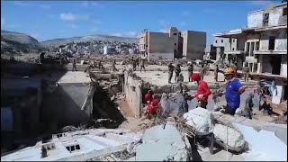
1/13
Swipe or click to see more
VIDEO COURTESY AP
2/13
Swipe or click to see more
MAXAR TECHNOLOGIES VIA AP
This satellite image from Maxar Technologies shows a port area of Derna, Libya, on July 1.3/13
Swipe or click to see more
MAXAR TECHNOLOGIES VIA AP
This satellite image from Maxar Technologies shows a port area of Derna, Libya, after flood damage on Wednesday, Sept. 13.4/13
Swipe or click to see more
MAXAR TECHNOLOGIES VIA AP
This satellite image from Maxar Technologies shows port facilities in Derna, Libya, on July 1.5/13
Swipe or click to see more
MAXAR TECHNOLOGIES VIA AP
This satellite image from Maxar Technologies shows port facilities in Derna, Libya, after a flood damaged the area on Wednesday, Sept. 13.6/13
Swipe or click to see more
MAXAR TECHNOLOGIES VIA AP
This satellite image from Maxar Technologies shows a neighborhood of Derna, Libya, on July 1.7/13
Swipe or click to see more
MAXAR TECHNOLOGIES VIA AP
This satellite image from Maxar Technologies shows a neighborhood of Derna, Libya, after a flood damaged the area on Wednesday, Sept. 13.8/13
Swipe or click to see more
MAXAR TECHNOLOGIES VIA AP
This satellite image from Maxar Technologies shows a neighborhood of Derna, Libya, on July 1.9/13
Swipe or click to see more
MAXAR TECHNOLOGIES VIA AP
This satellite image from Maxar Technologies shows a neighborhood of Derna, Libya, after a flood damaged the area on Wednesday, Sept. 13.10/13
Swipe or click to see more
MAXAR TECHNOLOGIES VIA AP
This satellite image from Maxar Technologies shows a coastal roadway in Derna, Libya, on July 1.11/13
Swipe or click to see more
MAXAR TECHNOLOGIES VIA AP
This satellite image from Maxar Technologies shows a coastal roadway in Derna, Libya, after a flood damaged the area on Wednesday, Sept. 13.12/13
Swipe or click to see more
MAXAR TECHNOLOGIES VIA AP
This satellite image from Maxar Technologies shows a coastal roadway in Derna, Libya, on July 1.13/13
Swipe or click to see more
MAXAR TECHNOLOGIES VIA AP
This satellite image from Maxar Technologies shows a coastal roadway in Derna, Libya, after a flood damaged the area on Wednesday, Sept. 13.
Pope Leo XIV leads Regina Caeli prayer from St. Peter’s Basilica

Punahou boys volleyball beats Kamehameha for Division I title

Back in the Day: Photos from Hawaii’s Past

Radford boys volleyball beats Kapaa for Division II title

UCLA ends Hawaii’s season in NCAA men’s volleyball semifinals

Mililani beats Maryknoll for state softball title

Waiakea ousts Baldwin in semis in state baseball

Kapaa beats Pearl City for Division II softball title


