Rains ease over Big Island; Hanauma Bay closed
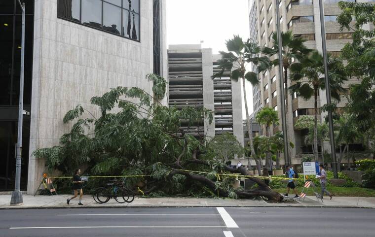
JAMM AQUINO / JAQUINO@STARADVERTISER.COM
A downed tree is seen on Bishop Street in downtown Honolulu, today, as the severe winter storm passes the eastern Hawaiian Islands after leaving a deluge of flooding, wind and rain damage.
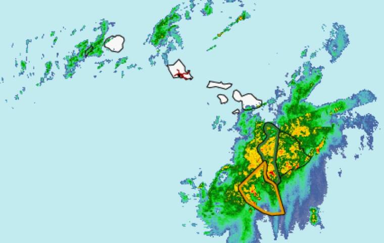
COURTESY NOAA
Radar this morning shows areas of moisture over the islands.
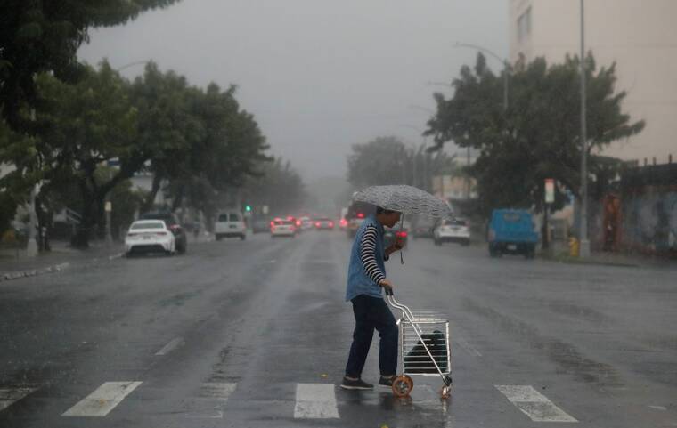
JAMM AQUINO / JAQUINO@STARADVERTISER.COM
A woman crosses South King Street in the rain Thursday in Honolulu.
UPDATE: 2:40 p.m.
The flood advisory and flood watch have been canceled for Hawaii island.
Radar shows that the heavy rain has diminished over Hawaii island and flooding is no longer a threat.
A wind advisory takes the place of the high wind warning for the summit of Haleakala. Forecasters say the area can expect southwest winds of 35 to 45 mph with gusts to 60 mph.
11 a.m.
The flash flood warning for Hawaii island has been replaced by a flood advisory, which is in effect until 1:30 p.m.
Don't miss out on what's happening!
Stay in touch with breaking news, as it happens, conveniently in your email inbox. It's FREE!
Radar and rain gauges at 10:33 a.m. showed rain easing over the west and south sides of Hawaii island, now falling at rates around 1 inch per hour, weather officials said. However, more rain is expected in the afternoon hours.
Some locations that will experience flooding include Kailua-Kona, Captain Cook, Waikoloa Village, Kapaau, Pohakuloa Training Area, Honaunau, Kealakekua, Kainaliu, Honalo, Holualoa, Kahaluu-Keauhou, Wood Valley, Puuanahulu, Kalaoa, Pahala, Punaluu Beach, Hawaiian Ocean View, Kawa Flats, Hawaii Volcanoes National Park and Naalehu.
9:50 a.m.
Hanauma Bay has been closed today due to unsafe conditions following the recent storm, city officials said this morning.
The National Weather Service also issued some updates:
>> There is a special weather statement due to a strong thunderstorm near Pahoa moving northeast at 40 mph. The statement is set to expire at 10:15 a.m.
>>The high wind warning for Hawaii island has been canceled.
>> The wind advisory for Maui County has been canceled.
8 a.m.
The National Weather Service has extended the flash flood warning for Hawaii island through 11 a.m. today.
Radar and rain gauges at 7:59 a.m. showed heavy rain over the west and south of Hawaii island falling at rates up to 2 inches per hour moving onshore, the NWS said. “Area streams remain elevated, and additional rainfall is likely to continue to move over the Big Island from the southwest this morning,” the NWS said in a bulletin.
Some locations that will experience flash flooding include Kailua-Kona, Captain Cook, Waikoloa Village, Kapaau, Pohakuloa Training Area, Honaunau, Kealakekua, Kainaliu, Honalo, Holualoa, Kahaluu-Keauhou, Wood Valley, Puuanahulu, Kalaoa, Pahala, Punaluu Beach, Hawaiian Ocean View, Kawa Flats, Naalehu and Hawaii Volcanoes National Park.
7:20 a.m.
Flooding and storm impacts have forced several public schools to close today, adding to the disruption caused by severe weather across the islands. Six schools in South Kona on the Big Island are shut down due to major flooding that has made access to campuses difficult. The affected campuses include Ho‘okena Elementary, Honaunau Elementary, Konawaena Elementary, Konawaena Middle, Konawaena High, and Ke Kula ʻO ʻEhunuikaimalino.
On Kauai’s North Shore, Kilauea Elementary is also closed today, but for a different reason — power outages have left the campus without running water. Meanwhile, all public schools in Maui County, including those on Maui, Molokai and Lanai, remain closed as previously announced.
With heavy rain, strong winds, and flash flooding continuing to affect parts of the state, officials urge families to stay updated on any further closures or emergency announcements.
PREVIOUS COVERAGE
The National Weather Service has extended a flash flood warning for Hawaii island until 8:15 a.m. today as heavy rain moves over the west side of the island.
At 5:02 a.m., radar and rain gauges showed peak rain rates of 1 to 3 inches per hour moving onshore in the North Kona District from Keauhou to Kailua-Kona, the NWS said. Additional rainfall is expected to continue through midmorning.
Forecasters warn of flooding in streams, rivers, roads and low-lying areas. Public road closures are possible, and landslides may occur in steep terrain. Areas that could experience flash flooding include Kailua-Kona, Captain Cook, Waikoloa Village, Kapaau, Honalo, Kainaliu, Kealakekua, Holualoa, Honaunau, Kahaluu-Keauhou, Pohakuloa Training Area, Puuanahulu, Kalaoa, Puako, Kawaihae, Kamuela, Kohala Ranch, Hawaiian Ocean View, Waipio Valley and Waimanu Valley.
An earlier flood watch for Maui has been canceled, but Hawaii island is under a flood watch until 6 p.m.
A high wind warning remains in effect until noon today for Hawaii island’s east, north, south, southeast, interior, Kohala and Kona districts. South winds of 20 to 35 mph with gusts over 60 mph are expected. Stronger winds of 50 to 70 mph, with gusts over 90 mph, are forecast for the summits of Mauna Kea and Mauna Loa through 6 a.m. Saturday.
The high wind warning for the summit of Haleakala is in effect until 6 p.m. Forecasters expect south to southwest winds of 45 to 65 mph with gusts over 80 mph.
A wind advisory is in effect until noon today for portions of Kahoolawe, Lanai, Maui and Molokai. Southwest winds of 20 to 30 mph with gusts up to 50 are forecast.
A winter storm warning is also in effect for Hawaii island summits, where 10 to 12 inches of snow could accumulate. Forecasters warn that travel to the summits could be difficult to impossible due to blowing snow and near-zero visibility at times. The warning is in effect through 6 a.m. Saturday.
A high surf advisory remains in effect until 6 p.m. today for the north-facing shores of Niihau, Kauai, Oahu, Molokai, Maui and Hawaii island, with surf expected to reach 12 to 18 feet.
Motorists are urged to use extreme caution, especially in areas prone to flooding and high winds. Travelers should check with their airlines for possible flight delays.
The strong storm system that moved into the islands overnight is now bringing heavy rain and thunderstorms to Hawaii island. The heaviest rain is expected to continue through this morning, with some areas seeing downpours strong enough to cause flash flooding. Roads, streams, and low-lying areas could flood quickly, especially where the ground is already soaked from earlier rain.
Powerful west winds are also sweeping across Hawaii island as the storm system moves through. These winds could knock down trees and power lines, making driving dangerous, especially for larger vehicles. The worst of the storm is expected to move east through the day, and drier air will start to move in from the west.
The weather will start easing this weekend across the islands as cooler, breezy tradewinds return. Skies should clear up in many areas, but some showers could still pop up, mostly along windward and mauka areas.
Looking ahead to next week, the forecast calls for cooler temperatures and steady tradewinds.


