Hurricane Kristy maintains strength in East Pacific

COURTESY NOAA
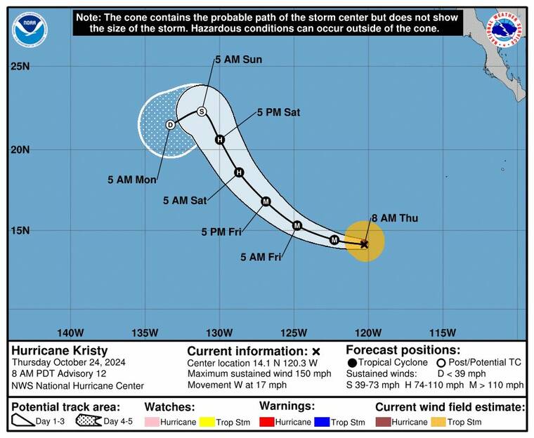
Hurricane Kristy’s five-day forecasted track as of 5 a.m. today.
Hurricane Kristy continued to move westward in the East Pacific today as a powerful Category 4 storm, but forecasters still expect it to weaken before reaching the Central Pacific.
As of 5 a.m., Kristy had maximum sustained winds of 150 mph, with higher gusts, and was located about 2,325 miles east-southeast of Hilo, according to the National Hurricane Center in Miami.
Kristy was moving west at 17 mph, with hurricane-force winds extending up to 25 miles from the center, and tropical-storm-force winds extending 105 miles.
Forecasters expect Kristy to possibly fluctuate in intensity through today before it rapidly weakens starting Friday as it turns northwest over cooler waters and encounters stronger wind shear.
By the end of the five-day forecast period, Kristy is expected to weaken significantly, becoming a remnant low as it approaches the Central Pacific.
Locally, light tradewinds are expected to persist over the next few days, bringing typical windward showers at night and isolated showers over interior and leeward areas during the afternoons, according to the National Weather Service.
Don't miss out on what's happening!
Stay in touch with breaking news, as it happens, conveniently in your email inbox. It's FREE!
As the weekend approaches, tradewinds will gradually strengthen, and wetter conditions are expected. A disturbance aloft and remnants of a frontal system could trigger heavier showers and thunderstorms on Saturday night and into Sunday.
Looking ahead, breezy and showery tradewind weather is forecast to continue into the middle of next week, with periods of increased rainfall across the islands.


