Hurricane Kristy rapidly intensifies, still no threat to Hawaii
COURTESY NOAA
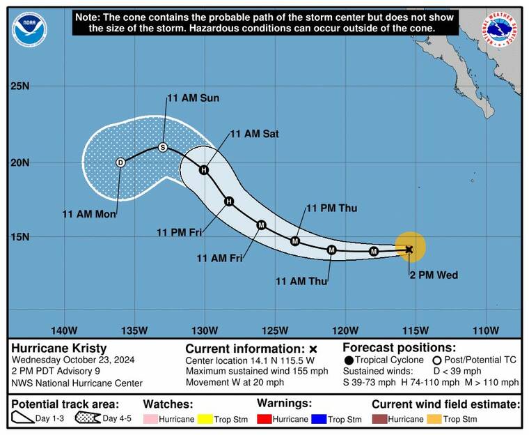
Hurricane Kristy’s five-day forecasted track as of 11 a.m. today.
UPDATE: 11 p.m.
Hurricane Kristy continued moving westward this evening with maximum sustained winds at 150 mph. It is located about 845 miles southwest of the southern tip of Baja California.
Kristy is moving toward the west near 17 mph, and a westward to west-northwestward motion is forecast through Thursday. A slower northwest to north-northwest motion is expected by late Friday.
1:30 p.m.
Hurricane Kristy has intensified rapidly today, reaching Category 4 status with sustained winds of 155 mph as of 11 a.m. Hawaii time, according to the National Hurricane Center in Miami.
The storm, located about 710 miles south-southwest of Baja California and 440 miles southwest of Socorro Island, is moving west at 20 mph.
Don't miss out on what's happening!
Stay in touch with breaking news, as it happens, conveniently in your email inbox. It's FREE!
Although Kristy has become a powerful hurricane, the storm remains far from land and poses no immediate threat to Hawaii or the West Coast. Forecasters expect Kristy to continue its westward track before turning northwest over the weekend, where it will likely encounter cooler waters and increased wind shear. This shift is expected to gradually weaken the storm starting Friday.
Hurricane-force winds extend up to 15 miles from Kristy’s center, with tropical storm-force winds stretching out 90 miles. Swells generated by Kristy could reach the Baja California coast by the end of the week, bringing dangerous surf and rip currents.
While Kristy is currently near its peak, forecasters predict the storm will start to gradually weaken Friday and dissipate into a remnant low by Monday as it moves toward the Central Pacific.
PREVIOUS COVERAGE
A tropical storm off the west coast of Mexico quickly formed into a major hurricane today but forecasters said they expect it to dissipate before it reaches the Central Pacific.
At 5 a.m. Hawaii time, Hurricane Kristy had maximum sustained winds of 125 mph, making it a Category 3 storm, and it was centered about 650 miles south-southwest of the southern tip of Baja California, according to the National Hurricane Center in Miami.
Kristy was moving west at 20 mph and hurricane-force winds extended up to 15 miles from the center while tropical storm-force winds extended 80 miles.
“Kristy is a relatively small hurricane that remains susceptible to rapid intensity fluctuations in a weak shear environment over warm (sea-surface temperatures),” forecasters said.
The hurricane is expected to continue moving west and peak as a Category 4 storm on Thursday with maximum sustained winds of 150 mph far from land in the East Pacific.
Forecasters then expect it to turn northwest over cooler waters and encounter stronger wind shear, which will combine to significantly weaken the storm.
By the end of the current five-day forecast period on Monday, Kristy is expected to be a remnant low with 35 mph winds as it nears the Central Pacific.