Tropical storms Gilma, Hector weakening quickly
COURTESY CPHC
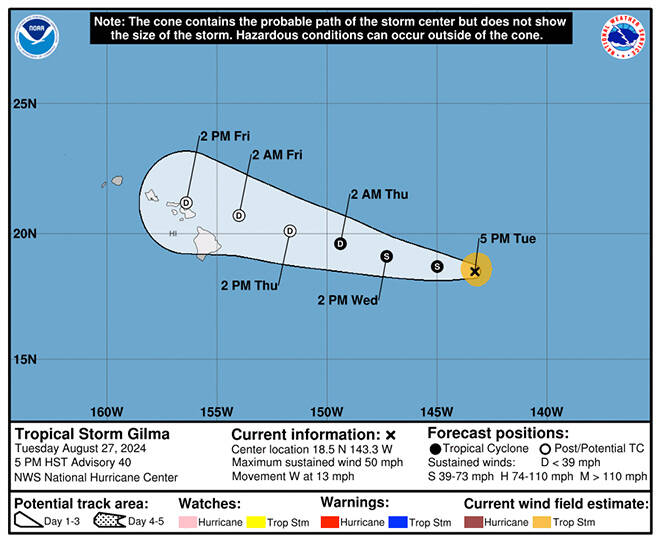
The 5-day forecast track for Hurricane Gilma as of 5 p.m. today.
NATIONAL HURRICANE CENTER
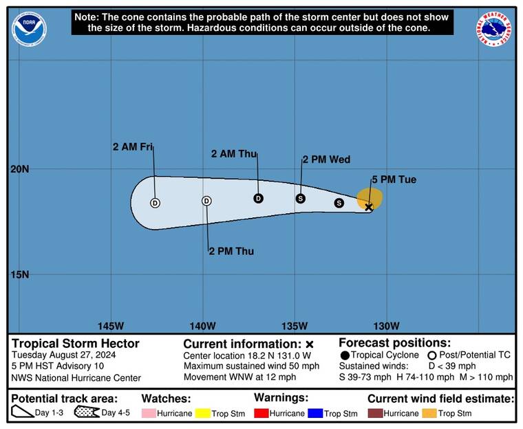
The 5-day forecast track for Tropical Storm Hector as of 5 p.m. today.
UPDATE: 6:55 p.m.
Colder sea-surface temperatures and wind shear are combining to quickly weaken Tropical Storm Gilma in the Central Pacific this evening.
At 5 p.m., Gilma was about 775 miles east of Hilo, moving west at 13 mph with maximum sustained winds of 50 mph, down 15 mph from the 11 a.m. update. “A motion between west and west-northwest is expected for the next few days, and on the forecast track the remnants of Gilma should approach the Hawaiian islands on Friday,” according to the Central Pacific Hurricane Center.
“The remnants of Gilma may bring heavy rainfall to portions of the Hawaiian islands as early as Friday, lasting through Saturday,” forecasters said. “Easterly swell generated by Gilma will build over waters around the Hawaiian Islands today and tonight. These swells may produce high surf along east-facing shores of some islands from Wednesday into Friday.”
Further away from Hawaii, Tropical Storm Hector was also weakening 1,400 miles west of the southern tip of Baja California, with maximum sustained winds of 50 mph.
Hector is forecast to dissipate by Friday as it enters the Central Pacific.
Don't miss out on what's happening!
Stay in touch with breaking news, as it happens, conveniently in your email inbox. It's FREE!
11:40 a.m.
Gilma continues to weaken and is now a tropical storm in the Central Pacific where it is expected to dissipate as it approaches Hawaii later this week.
As of 11 a.m., Gilma was about 850 miles east of Hilo, with maximum sustained winds of 65 mph, moving west at 15 mph, according to the Central Pacific Hurricane Center. The tropical storm-force winds reach up to 70 miles from the center.
Tropical-storm-force winds also extend outward up to 70 miles from the center.
National Weather Service forecasters expect Gilma to become a tropical depression then dissipate as it approaches Hawaii from the northeast on Friday.
“Local impacts will depend on Gilma’s track, but will likely be minimal,” forecasters said.
Surf along eastern shores is expected to climb Wednesday or later due to an easterly swell from Gilma.
The timing of the heaviest rainfall for Hawaii from Gilma is uncertain, forecasters said, but based on the current track it could happen between Thursday evening and Saturday morning.
For today, forecasters said, “more typical summertime tradewind weather is on tap,” with some low clouds and showers moving into windward and mauka areas on the trades this morning. Tradewinds are expected to remain moderate to locally breezy through the week.
A wetter tradewind pattern is expected to begin tonight, with heavier showers for windward and mauka areas.
Tropical Storm Hector in the East Pacific, meanwhile, has strengthened slightly as it continues its west-northwestward path, but forecasters also expect it to dissipate by the end of the week, far from Hawaii.
Hector, which at 11 a.m. was about 1,335 miles west-southwest of the southern tip of Baja, Calif., had a slight increase in maximum sustained winds to 50 mph, with a forward speed of 12 mph, according to weather officials.
Forecasters expect remnants of Hector to follow closely behind Gilma as potentially a weak surface trough sometime Saturday night into Sunday.
“Little to no impacts are expected from Hector at this time,” said forecasters.
PREVIOUS COVERAGE
Hurricane Gilma is rapidly losing strength as it moves into the Central Pacific basin. With maximum sustained winds of 75 mph at 5 a.m., the storm was centered about 945 miles east of Hilo and moving west at 13 mph, according to the National Hurricane Center in Miami.
Forecasters predict that Gilma will continue to weaken, potentially becoming a remnant low by Thursday night. The hurricane-force winds extend 15 miles from Gilma’s center, while tropical-storm-force winds reach up to 70 miles.
Meanwhile, Tropical Storm Hector continues its west-northwestward path. Located about 1,270 miles southwest of the southern tip of Baja California at 5 a.m., Hector’s maximum sustained winds decreased to 45 mph, with a forward speed of 12 mph, according to weather officials.
RELATED STORY: Tropical cyclones coming toward Hawaii at peak of season Opens in a new tab
Hector is expected to gradually weaken starting tonight. Tropical-storm-force winds extend outward up to 90 miles from Hector’s center.
In the Central Pacific, but moving away from Hawaii, is Tropical Storm Hone.
As of 5 a.m. today, Hone was located about 495 miles west of Honolulu, 415 miles west-southwest of Lihue and moving west at 14 mph with maximum sustained winds of 50 mph, according to the Central Pacific Hurricane Center. Gradual weakening is expected over the next couple of days, with Hone likely becoming a post-tropical low on Thursday before dissipating on Friday.


