Hawaii island under tropical storm warning as Hone approaches
CENTRAL PACIFIC HURRICANE CENTER
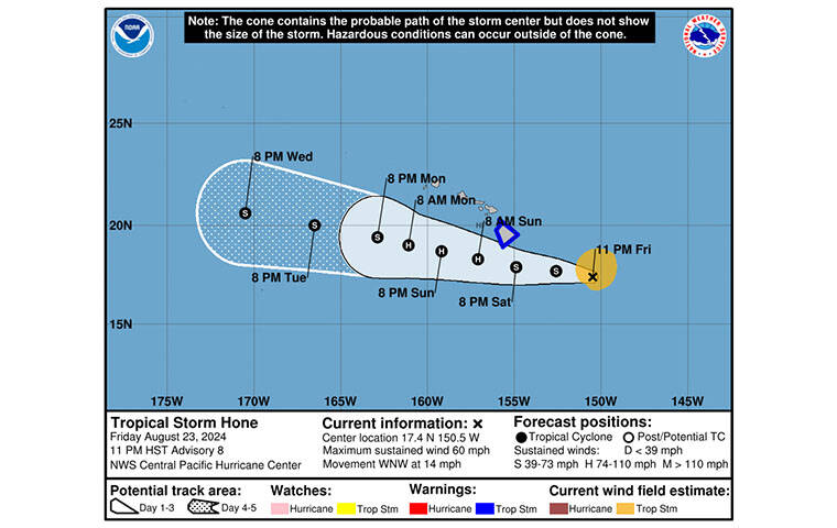
The 5-day forecast track for Tropical Storm Hone as of 11 p.m.
NATIONAL HURRICANE CENTER
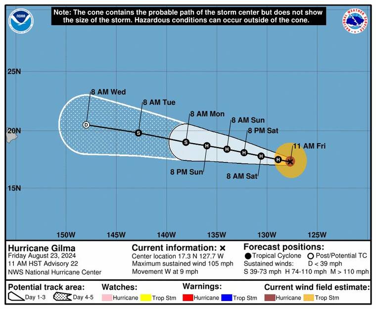
The 5-day forecast track for Hurricane Gilma.
UPDATE: 11 p.m.
Tropical Storm Hone strengthened slightly tonight as it continued a westward path to Hawaii island.
Hone, with maximum sustained winds at 60 mph, is located about 340 miles east-southeast of Hilo and 550 miles east-southeast of Honolulu as of 11 p.n.
Hone is moving toward the west-northwest near 14 mph and this motion toward the west is expected to continue over the next several days with a gradual decrease in forward speed.
The center of Hone is expected to pass near or south of the Big Island Saturday night into early Sunday. A tropical storm warning was issued for the Big Island earlier today.
Hone is expected to produce rainfall of 5 to 10 inches over mainly windward and southeast facing slopes of the Big Island, with locally higher amounts possible. Rainfall totals of 2 to 4 inches will be possible over portions of the smaller islands, mainly windward.
Don't miss out on what's happening!
Stay in touch with breaking news, as it happens, conveniently in your email inbox. It's FREE!
Some strengthening is forecast during the next 48 hours and Hone is forecast to become a hurricane Sunday through Monday southwest of the Big Island.
Hurricane Gilma, with maximum sustained winds at 100 mph, is 1,690 miles east of Hilo as of 11 p.m.
Gilma is moving toward the west near 9 mph and a slightly faster westward to west-northwestward motion is expected during the next few days.
Slight weakening is forecast during the next day or two, but Gilma is expected to remain a hurricane this weekend. Steady weakening is anticipated early next week.
8 p.m.
A tropical storm warning remains in effect for the Big Island as Hone continues its westward trek.
Hone, with maximum sustained winds at 50 mph, is 380 miles east-southeast of Hilo and 595 miles east-southeast of Honolulu as of 8 p.m.
The center of Hone is expected to pass near or south of the Big Island Saturday night into early Sunday. Hone is expected to produce rainfall of 5 to 10 inches over mainly windward and southeast facing slopes of the Big Island, with locally higher amounts possible. Rainfall totals of 2 to 4 inches will be possible over portions of the smaller islands, mainly windward.
A tropical storm warning means that tropical storm conditions are expected somewhere within the warning area within 36 hours.
5:20 p.m.
The Central Pacific Hurricane Center has issued a tropical storm warning for Hawaii Opens in a new tabisland Opens in a new tab, meaning tropical storm conditions are expected in the area within 36 hours.
Some areas of the Big Island could see rainfall amounts of 4 to 8 inches. Wind forecasts vary across the islands but some areas could see sustained winds of 30 to 40 mph with gusts up to 60 mph. The summits of Mauna Kea and Mauna Loa could see gusts of 80 mph.
As of 5 p.m., Tropical Storm Hone was centered 425 miles east-southeast of Hilo, with maximum sustained winds of 50 mph, traveling west at 16 mph.
This motion is expected over the next few days, with the center of Hone expected to pass near or south of Hawaii island Saturday night into early Sunday. The latest five-day forecast track has Hone passing far south of the other islands as a strong tropical storm or Category 1 hurricane into early next week.
The National Weather Service has issued a wind advisory for leeward areas of all islands, warning of strong downslope winds as Hone passes, effective from 6 a.m. Saturday to 6 a.m. Monday,
Northeast winds of 25 to 35 mph, with localized gusts over 50 mph are expected for portions of Niihau, Kauai, Lanai, Maui, Molokai, Kahoolawe, and Oahu.
“Winds this strong can tear off shingles, knock down tree branches, blow away tents and awnings and make it difficult to steer, especially for drivers of high profile vehicles,” officials warned. “Watch out for falling tree branches when walking or driving. Make sure tents and awnings are secure or take them down. Be prepared for power outages.”
4:35 p.m.
A red flag warning is in effect Saturday for leeward sections of all Hawaiian islands as winds from the approaching Tropical Storm Hone and dry weather conditions combine to increase the threat of wildfires.
The National Weather Service said the warning is in effect from 10 a.m. to 6 p.m. Saturday.
The warning comes as Hone, which is expected to pass south of the islands, promises to bring northeast winds of 30 to 40 mph with localized gusts up to 50 mph, officials said.
“A combination of strong winds, low relative humidity, and dry fuels can contribute to extreme fire behavior. Any fires that develop will likely spread rapidly,” the warning said.
A red flag warning means that critical fire weather conditions are either occurring now or will shortly,” forecasters said, adding that the warning does not predict new fire starts.
“Delay activities that could throw off sparks until the wind dies down. Outdoor burning is not recommended,” the warning said.
———
For more information, go to www.hawaiiwildfire.org/home Opens in a new tab.
4:15 p.m.
The National Weather Service has issued a high surf advisory for the eastern shores of Hawaii island from 6 p.m. today to 6 a.m. Sunday.
Forecasters say a short-period swell associated with Tropical Storm Hone is expected to build tonight, peak Saturday then fade on Sunday.
The public should beware of large, breaking waves of 7 to 10 feet along Hawaii island’s east shores, where strong currents will make swimming dangerous, forecasters warned.
A tropical storm watch remains in place for Hawaii island.
As of 2 p.m. today, Hone was about 470 miles east-southeast of Hilo, with maximum sustained winds of 50 mph, according to the Central Pacific Hurricane Center.
Hone is traveling west at 16 mph, with some strengthening forecast over the next 48 to 72 hours.
A wind advisory is in effect from 6 a.m. Saturday to 6 a.m. Monday for parts of Kahoolawe, Kauai, Lanai, Maui, Molokai, Niihau and Oahu, the weather service said.
Northeast winds 30 to 40 mph with localized gusts over 50 mph are expected, forecasters said.
“Winds this strong can tear off shingles, knock down tree branches, blow away tents and awnings and make it difficult to steer, especially for drivers of high profile vehicles,” the advisory says.
On Saturday, forecasters are also expecting winds to strengthen on the Big Island, with widespread gusts of about 40 to 50 mph likely late in the day through early Sunday.
The strongest gusts are expected around South Point and Ka Lae; downslope from Mauna Kea, Mauna Loa, the Kohala Mountains; and at Humuula Saddle, which could exceed 50 mph.
Also, forecasters say drier air is expected to move across the state on Saturday ahead of Hone.
A red flag warning may be issued Saturday afternoon due to the combination of dry conditions ahead of Hone, along with, strong, downslope winds, which will bring elevated fire weather concerns to leeward sides.
These fire concerns decrease late Saturday as Hone brings rains to the state, which are expected to intensify through Sunday.
A flood watch for Hawaii island remains in effect, starting Saturday afternoon.
In advance of Tropical Storm Hone, the state Division of Forestry and Wildlife said it is closing camping areas and rescheduling special hunts this weekend. Ainapo cabin, Keanakolu cabin, and Waimanu campsites will be closed, DOFAW officials said. Notifications have been sent to all campers who requested permits.
11 a.m.
A tropical storm watch remains in place for Hawaii County as a stronger Tropical Storm Hone continues to move westward toward the Hawaiian islands.
As of 11 a.m. Hone was about 520 miles east-southeast of Hilo, with maximum sustained winds of 50 mph and moving west at 16 mph.
Tropical-storm-force winds extend outward up to 115 miles from the center.
The westward motion is expected to continue over the next few days, with the forward speed gradually slowing.
Based on the current forecast track, the center of Hone is expected to pass near or south of Hawaii island Saturday night into early Sunday.
Hone is expected to bring strong winds, intense rainfall of 5 to 10 inches, with locally higher amounts, particularly to southeast and east-facing slopes, and swells strong enough to cause life-threatening surf and rip currents.
The National Weather Service of Honolulu has issued a tropical storm warning for waters around the Hawaiian islands, and a tropical storm watch for Hawaii island.
Winds could potentially reach between 39 to 57 mph, NWS said, and Naalehu and Pahala residents should be making efforts to protect property now.
Potential impacts include damage to porches, awnings, carports, sheds and unanchored mobile homes, plus large tree limbs breaking off. There could also be potentially hazardous driving conditions on bridges and other elevated roadways, plus scattered power and communication outages.
NWS has also issued a flood watch for Hawaii island, warning of the potential for flash flooding brought by Hone, starting Saturday afternoon.
Hurricane Gilma, meanwhile continues weakening as it moves westward toward Hawaii.
As of 11 a.m., Gilma was about 1,800 miles east of Hilo, with maximum sustained winds of 105 mph, moving west at 9 mph.
Hurricane-force winds extended outward up to 35 miles from the center and tropical-storm-force winds extended outward up to 115 miles.
Gilma is expected to remain a hurricane through much of the weekend but is forecast to continue weakening while traveling westward over the next few days.
PREVIOUS COVERAGE
Hurricane Gilma continues to weaken as it moves across the Eastern Pacific, while Tropical Storm Hone is on a path that could bring wet and windy conditions to the Hawaiian islands by this weekend.
Tropical Storm Hone was located about 620 miles east-southeast of Hilo as of 5 a.m., with maximum sustained winds near 45 mph with higher gusts. The storm is moving westward at 16 mph and is expected to continue strengthening over the next few days.
Forecasters warn that Hone could bring heavy rain, damaging winds and large surf to the Hawaiian islands from Saturday through Monday.
Up to 4 to 8 inches of rainfall is possible along the windward side of the Hawaii island and 2 to 4 inches along the windward areas of the smaller islands.
A flood watch has been posted for Hawaii island from Saturday afternoon through Monday evening.
“Flood-prone roads and other low lying areas may be closed due to elevated runoff and overflowing streams,” the National Weather Service said. “Urban areas may receive more significant flooding and property damage due to rapid runoff.”
A tropical storm watch remains in effect for Hawaiian Ocean View Estates on Hawaii island. The watch area could see wind up to 39 to 57 mph.
Swells generated by the tropical storm are expected to reach the islands this weekend, likely causing “life-threatening surf and rip currents,” according to the CPHC.
Breezy tradewinds with windward and mauka showers should persist for today though, forecasters say.
Meanwhile, Gilma continues to churn over open waters, gradually losing strength but still packing a powerful punch. As of 5 a.m. today, the Category 3 hurricane was located about 1,855 miles east of Hilo, moving westward at 8 mph, according to the National Hurricane Center in Miami.
Gilma’s maximum sustained winds have decreased to 115 mph, with higher gusts, and further weakening is expected over the coming days. Despite this, the storm is forecast to remain a hurricane through much of the weekend. Hurricane-force winds extend up to 35 miles from Gilma’s center, with tropical-storm-force winds reaching out 115 miles.
The storm poses no immediate threat to land.


