Tropical Storm Gilma strengthens in Eastern Pacific

NATIONAL HURRICANE CENTER IN MIAMI
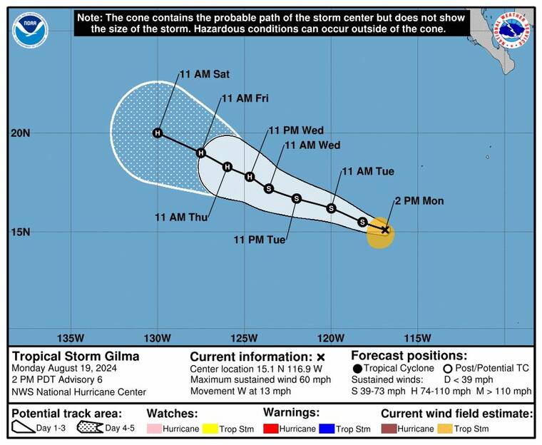
Tropical Storm Gilma gained strength this morning off the coast of Baja California.
The National Hurricane Center is tracking Tropical Storm Gilma and a few other disturbances in the Eastern North Pacific.
As of 5 p.m., Tropical Storm Gilma was about 705 miles southwest of the southern tip of Baja California, with maximum sustained winds of 60 mph, with higher gusts, and traveling west at 13 mph.
Tropical-storm-force winds extended outward up to 80 miles, and Gilma is forecast to approach hurricane strength in a few days.
A slower, west-northwest motion is expected to begin tonight through midweek.
Forecasters said another disturbance, EP90, is currently well east-southeast of the Hawaiian islands, but that a tropical depression is likely to form over the next few days.
“The disturbance is forecast to meander slowly northward or northeastward during the next few days, before accelerating west-northwestward into the Central Pacific basin by the latter portion of the week,” said forecasters.
Don't miss out on what's happening!
Stay in touch with breaking news, as it happens, conveniently in your email inbox. It's FREE!
Another storm west-southwest of the southern tip of Baja California has not become any better organized today and is forecast to move slowly toward the northwest over the next few days. It could interact with EP90 to its west or Gilma to its east, limiting its potential for formation.
This storm could also form into a tropical depression within the next few days.
The National Weather Service of Honolulu said it could get particularly windy and wet across portions of the state over the weekend, depending on the track and development of EP90, which currently resides well southeast of the island chain.
However, the eventual track of EP90 remains uncertain, forecasters said, and the public should stay tuned over the next few days.


