Rain showers continue to soak saturated Oahu

JAMM AQUINO/JAQUINO@STARADVERTISER.COM
Nearly whiteout conditions due to heavy rains are seen on South Beretania Street, this morning. The remaining kona low continues to bring the threat of heavy rains and flooding through Friday.

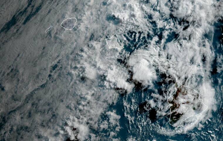
COURTESY NOAA/NESDIS/STAR GOES-WEST
Areas of moisture are seen around the islands in this satellite image today.


UPDATE: 3:33 a.m.
A flood advisory has been extended until 5 a.m. for Oahu due to excessive rainfall.
“At 3:30 a.m., radar indicated moderate rain over the south shore and eastern Oahu,” the updated advisory said. “Rain was falling at a rate of 0.5 to 1.0 inches per hour. Additional rainfall is developing to the south and is expected to continue to move northward into Oahu during the next few hours. Stream levels remain elevated across the island.”
A Flood Watch is also in effect through Friday evening.
This advisory may need to be extended beyond 5 a.m. if flooding persists.
11:10 p.m.
Don't miss out on what's happening!
Stay in touch with breaking news, as it happens, conveniently in your email inbox. It's FREE!
The flood advisory for Oahu has been extended until 2 a.m. as rain continues to fall throughout the already-saturated island.
“At 10:45 p.m., radar indicated moderate rain over eastern Oahu,” the updated advisory said. “Rain was falling at a rate of around 1 inch per hour. Rainfall is redeveloping to the south and is expected to begin moving back into central and west Oahu in the next hour or two. Stream levels also continue to run high across the island.”
The advisory includes the entire island of Oahu.
Stay away from streams, drainage ditches and low lying areas prone to flooding.
Rainfall and runoff will also cause hazardous driving conditions due to ponding, reduced visibility and poor braking action.
8:15 p.m.
The flood advisory for Oahu has been extended until 11 p.m. as rain continues to fall throughout the already-saturated island.
“At 7:59 p.m., radar indicated moderate rain over eastern Oahu,” the updated advisory said. “Rain was falling at a rate of around 1 inch per hour. Rainfall has decreased in coverage and intensity, but additional rain continues to move in from the south and stream levels continue to run high.”
The advisory includes the entire island.
Oahu, Niihau, Kauai, Molokai, and Lanai remain under a flood watch through Friday evening.
Meanwhile, city officials said that the Kailua-bound lanes of Kalanianaole Highway are shut down from Castle Junction to Kapaa Quarry Road for road work after Thursday’s heavy rain downed a tree and sent mud and other debris onto the roadway.
Motorists were advised to use an alternate route and to avoid the area.
“Vehicles are being rerouted through Maunawili and onto Kamehameha Highway, officials said.
5:15 p.m.
A flood advisory has been posted again for Oahu due to excessive rainfall. The flood advisory has expired for Hawaii island.
The flood advisory for the entire island of Oahu is in effect until 8:15 p.m. today.
At 5:01 p.m., the radar showed moderate to heavy rain over the northwestern half of Oahu. The highest rainfall rates were up to 1 inch per hour over the Waianae mountains and Central Oahu. Forecasters said the rainfall is expected to spread eastward as showers move in from the south.
A flood watch is still in effect through Friday evening for Niihau, Kauai, Oahu, Molokai and Lanai.
In addition, a high surf advisory remains for the south-facing shores of all Hawaiian Islands until 6 p.m. Friday.
3:27 p.m.
The flood advisory for Hawaii island has been extended through 6:45 p.m. today.
Radar at 3:23 p.m. showed heavy showers over the upper North and South Hilo districts as rain fell at a rate of 1 to 2 inches per hour over a portion of Saddle Road between Kaumana and Maunakea Access Road. Forecasters said the heavy rainfall should end by sunset.
Some locations that will experience flooding include Hilo, Pohakuloa Camp, Pohakuloa Training Area, Volcano, Glenwood, Mountain View and Hawaii Volcanoes National Park.
The flood watch has expired for Maui and Kahoolawe, but remains in effect through Friday for Oahu, Kauai, Lanai, Molokai and Niihau.
2:44 p.m.
The flood advisory for Oahu has expired, but the flood watch for Kauai, Niihau, Oahu, Molokai, Lanai, Kahoolawe, and Maui remains through Friday evening.
1 p.m.
A flood advisory has been posted for Hawaii island through 3:45 p.m. today.
Radar at 12:35 p.m. showed heavy rain falling at a rate of 1 to 2 inches per hour over a portion of Saddle Road between Kaumana and the Mauna Kea Access Road, forecasters said. Heavy rain was mostly over the upper North Hilo and South Hilo districts. However, rainfall is forecast to ease by mid-afternoon.
Some locations that will experience flooding include Hilo, Pohakuloa Camp, Pohakuloa Training Area, Volcano, Glenwood, Mountain View and Hawaii Volcanoes National Park.
The flood advisory for Oahu remains in effect until 3:45 p.m. today along with the flood watch for Kauai, Niihau, Oahu, Molokai, Lanai, Kahoolawe, and Maui through Friday evening.
“Fortunately, these heavy showers are moving rather quickly, which has somewhat limited flooding impacts thus far this morning,” forecasters said. “However, soils have become saturated with 24-hour rainfall totals over Oahu in the 1-2 inch range for many locations. As showers continue to train over these saturated areas throughout the day, expect flash flooding concerns to amplify and streams to become more responsive to downpours.”
In addition, a high surf advisory for the south-facing shores of all Hawaiian Islands is in effect until 6 p.m. Friday. Surf of 7 to 10 feet is forecasted as strong breaking waves and strong currents are expected to make swimming dangerous.
“Rough conditions are expected along south facing shores through Friday due to a combination of breezy onshore winds and a fresh, long-period south-southwest swell filling in. This swell will peak later today through Friday,” forecasters said.
Meanwhile, the Honolulu Zoo will be closed today due to ponding and flooded walkways.
RELATED: View the latest weather-related road closures on Oahu
11:40 a.m.
The flood advisory for Oahu has been extended to 2:45 p.m.
Radar and rain gauges at 11:27 a.m. showed rains have eased across Oahu, the NWS said. However, stream gauges show that flow levels are elevated in many areas and satellite and radar show more rainfall moving toward Oahu from the south.
10:40 a.m.
Flooding has forced the closure of the right lane of Farrington Highway westbound at Lualualei Naval Road.
10:30 a.m.
Flooding has forced the closure of the westbound lanes of Farrington Highway in Mailiili, according to the state Department of Transportation.
A downed tree and landslide have also forced the closure of the right lane of the Pali Highway Honolulu-bound at Castle Junction. Police are on scene and a crew is on the way to clear the road.
10:20 a.m.
The Diamond Head State Monument has been closed today due to heavy rain, according to the Department of Land and Natural Resources.
The rain is causing heavy runoff and minor rockslides at the tunnel entrance and along the trail, a department spokesperson said.
9:25 a.m.
Flooding has forced the closure of Kapaa Quarry Road from Mokapu Saddle Road to Mokapu Quarry Road.
8:40 a.m.
The flood advisory for Oahu has been extended to 11:45 a.m. today.
Radar at 8:32 a.m. showed that the area of heavy rainfall has expanded from East Oahu to cover the entire island, the NWS said.
Rain was observed falling at rates of 1 to 2 inches per hour from Manoa to Hawaii Kai, according to the NWS. Ponding was reported on some roads in Kapolei, and a lane of the H-1 freeway was closed between Fort Weaver Road and Makakilo Drive.
7:35 a.m.
A flood advisory has been posted for Oahu through 10:30 a.m. today.
Radar at 7:29 a.m. showed heavy bands of rain over East Oahu falling at rates of 1 to 2 inches per hour over the Maunawili and Waimanalo areas, the NWS said. More rainfall is moving toward Oahu from the south.
Some locations that will experience flooding include Honolulu, Kaneohe, Ahuimanu, Kalihi, Maunawili, Kahaluu, Moanalua, Manoa, Halawa, Aiea, Waiahole, Kailua, Salt Lake, Kaneohe Marine Base, Palolo, Waikane, Waimanalo, Pearl City and Kaaawa.
>> RELATED: Heavy rain causes Pali, Kalanianaole highways lane closures
Residents and visitors are advised to stay away from streams, drainage ditches and low-lying areas prone to flooding.
The advisory may need to be extended if flooding persists.
PREVIOUS COVERAGE
Although all flood advisories were canceled overnight, most of the state remains under a flood watch as a kona low continues to pull tropical moisture over the islands.
A flood watch remains in effect for Kauai County, Oahu and Maui County through Friday evening.
“Significant flooding may occur due to the overflow of streams and drainages,” the National Weather Service said in a bulletin this morning. Roads in several areas may be closed and property damage may occur in urban or low-lying spots due to runoff. Areas with steep terrain may also be at risk for landslides.
As of 3:51 a.m., weather officials said a kona low remains in place about 600 miles north to northwest of the main Hawaiian islands drawing unstable tropical moisture over the islands over the next few days.
Bands of moderate to heavy rain and thunderstorms will dampen most islands through Friday, forecasters said. However, the kona low will begin to drift away from the islands this weekend, easing conditions over the western half of the state.
Tradewinds are expected to Monday along with milder weather for all islands.
Gov. Josh Green signed an emergency proclamation Wednesday evening in response to the kona low weather event.
The emergency proclamation went into effect immediately and allows the adjutant general to activate units of the National Guard to work in coordination with local authorities, emergency management agencies and others to mitigate the impact of the storm.
County and state agencies are directed to provide emergency relief and engage in emergency management functions. The Hawaii Emergency Management Agency is on partial activation.


