Hurricane Jova continues to weaken in East Pacific

NATIONAL HURRICANE CENTER
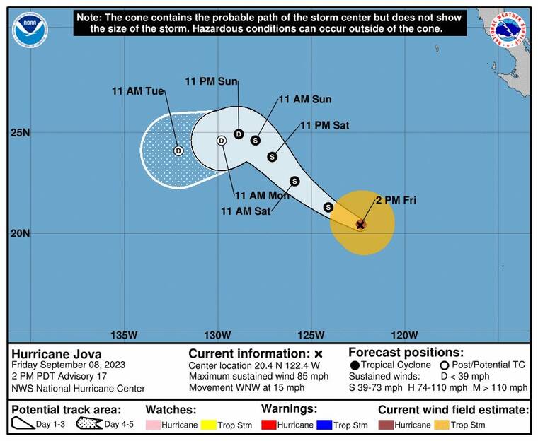
The 5-day track for Hurricane Jova.
UPDATE: 1:30 p.m.
Hurricane Jova continues to lose steam in the East Pacific as it maintains a west-northwest trajectory.
As of 11 a.m.. today Jova was located 2,115 miles east of Hilo and 2,290 miles east of Honolulu while packing maximum sustained winds of 85 mph and moving west-northwest at 15 mph, according to the National Hurricane Center in Miami.
Now a Category 1 hurricane, weather officials expect Jova to continue on its current course while weakening and decreasing in forward speed over the next few days.
Hurricane-force winds extend outward up to 25 miles from Jova’s center and tropical-storm-force winds extend outward up to 125 miles.
PREVIOUS COVERAGE
Don't miss out on what's happening!
Stay in touch with breaking news, as it happens, conveniently in your email inbox. It's FREE!
Although it continues to track west-northwest in the East Pacific, Hurricane Jova is weakening as forecast.
As of 5 a.m. today Jova was located 2,200 miles east of Hilo and 2,370 miles east of Honolulu while packing maximum sustained winds of 100 mph and moving west-northwest at 16 mph, according to the National Hurricane Center in Miami.
Now a Category 2 hurricane, weather officials expect Jova to continue on its current course while weakening and decreasing in forward speed over the next few days.
Hurricane-force winds extend outward up to 25 miles from Jova’s center and tropical-storm-force winds extend outward up to 125 miles.
Forecasters expect tradewinds to remain light today with a few leeward showers possible this afternoon. However, trades should build on Saturday and Sunday with moderate to breezy conditions expected Sunday through the middle of next week.


