Tropical Storm Irwin expected to weaken in East Pacific

NATIONAL HURRICANE CENTER
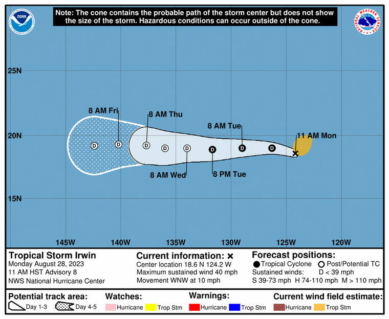
The 5-day forecast track for Tropical Storm Irwin as of 11 a.m. today.
UPDATE: 11:19 a.m.
Tropical Storm Irwin, which is moving west-northwestward over cooler waters, is expected to weaken before it nears the Hawaiian Islands.
As of 11 a.m., the National Hurricane Center in Miami said Irwin was located about 970 miles west-southwest of the southern tip of Baja California with maximum sustained winds of 40 mph with higher gusts. Irwin was moving west-northwest at 10 mph and expected to move toward the west.
Forecasters predict Irwin will gradually weaken over the next few days and become a remnant low by Wednesday or sooner.
Tropical-storm-force winds extend outward up to 140 miles from the center.
There are no coastal watches or warnings in effect.
Don't miss out on what's happening!
Stay in touch with breaking news, as it happens, conveniently in your email inbox. It's FREE!
EARLIER COVERAGE
Tropical Storm Irwin held steady overnight in the East Pacific but is still expected to weaken over the next few days.
The National Hurricane Center in Miami said as of 5 a.m. Irwin was 950 miles west-southwest of the southern tip of Baja California and 2,060 miles east of Hilo, with maximum sustained winds of 40 mph, and moving west-northwest at 8 mph. Tropical storm-force winds extend up to 255 miles from Irwin’s center.
Forecasters expect Irwin to take a turn toward the west shortly and continue on that track over several days.
The five-day forecast for the storm calls for it to be a post-tropical remnant low by Wednesday, with 35 mph winds when it enters the Central Pacific by Friday, still hundreds of miles east of Hilo.


