Tropical Storm Irwin forms in East Pacific, but expected to dissipate

COURTESY NHC
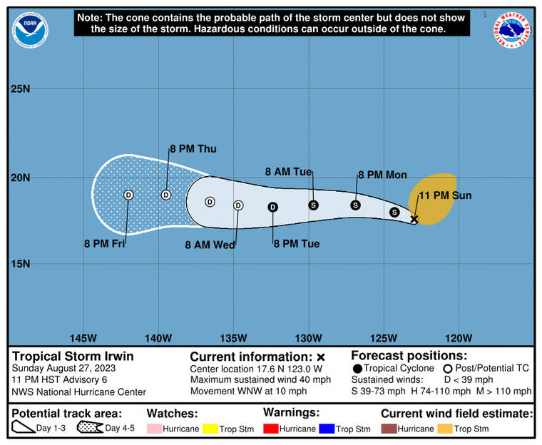
The five-day forecast map for Tropical Storm Irwin as of Sunday, 11 p.m.
5 p.m.
Tropical Storm Irwin formed today in the East Pacific but the storm is forecast to dissipate soon after entering the Central Pacific late this week.
The National Hurricane Center in Miami said as of 5 p.m., Irwin was 900 miles west-southwest of the southern tip of Baja California, with maximum sustained winds of 40 mph, and moving west-northwest at 12 mph. Tropical storm-force winds extend up to 230 miles from Irwin’s center.
The five-day forecast for the storm calls for it to be a post-tropical remnant low with 30 mph winds when it enters the Central Pacific by Friday, still hundreds of miles west of Hilo.
11 a.m.
Tropical Storm Irwin formed today in the East Pacific but the storm is forecast to dissipate soon after entering the Central Pacific late this week.
Don't miss out on what's happening!
Stay in touch with breaking news, as it happens, conveniently in your email inbox. It's FREE!
The National Hurricane Center in Miami said as of 11 a.m. Irwin was 835 miles west-southwest of the southern tip of Baja California, with maximum sustained winds of 40 mph, and moving west-northwest at 10 mph. Tropical storm-force winds extend up to 60 miles from Irwin’s center.
The five-day forecast for the storm calls for it to be a post-tropical remnant low with 30 mph winds when it enters the Central Pacific by Friday, still hundreds of miles west of Hilo.


