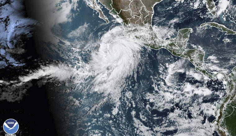
Hurricane Hilary strengthens off Mexico’s Pacific coast

NOAA VIA ASSOCIATED PRESS
This satellite image taken at 10:50 a.m. EDT today, and provided by the National Oceanic and Atmospheric Administration (NOAA) shows Hurricane Hilary off the Pacific coast of Mexico.
MEXICO CITY >> A strengthening Hurricane Hilary was near major storm status off Mexico’s Pacific coast today, and it could bring heavy rain to the southwestern U.S. by the weekend.
The U.S. National Hurricane Center said Hilary had maximum winds of 110 mph at midafternoon, just 1 mph below a Category 3 storm. It was on a projected path that threatened landfall on the central Baja California peninsula by Sunday or possibly keep just offshore while heading for Southern California.
Hilary was centered about 475 miles south of Los Cabos on the southern tip of the Baja peninsula. It moving west-northwest at 14 mph (22 kph), but was expected to take a more northward heading in the coming days.
The hurricane center said that as Hilary moves onto or brushes the Baja peninsula, it could possibly survive briefly as a tropical storm or tropical depression and cross the U.S. border.
No tropical storm has made landfall in Southern California since Sept. 25, 1939, according to the National Weather Service.
“Rainfall impacts from Hilary within the Southwestern United States are expected to peak this weekend into Monday,” the hurricane center said. “Flash, urban, and arroyo flooding is possible with the potential for significant impacts.”
Don't miss out on what's happening!
Stay in touch with breaking news, as it happens, conveniently in your email inbox. It's FREE!
The area potentially affected by heavy rainfall could stretch from Bakersfield, California, to Yuma, Arizona, as well as some parts of southern Nevada.
The outlook for excessive rainfall in Southern California stretches from Sunday to Tuesday, according to the Los Angeles weather office.
While the odds are against Hilary making landfall in California as a tropical storm, there is a high chance of major rain and flooding, UCLA climate scientist Daniel Swain said in an online briefing Wednesday.


