Dora weakens slightly on march toward Central Pacific basin

COURTESY NATIONAL HURRICANE CENTER
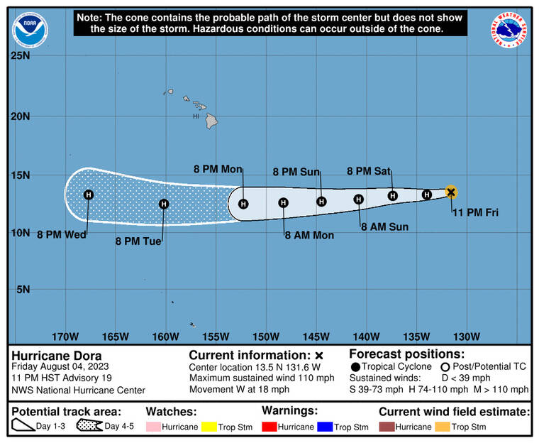
The five-day forecast for Hurricane Dora as of 11 p.m. Friday.
Update, 11 p.m.
Hurricane Dora continued to move westward this evening and is expected to enter the Central Pacific on Sunday.
Dora, located 1,640 miles east of the Big Island, is moving west at 18 mph with winds at 110 mph.
Some weakening is forecast through Saturday, followed by little change in strength on Sunday and Monday.
5 p.m.
Dora weakened slightly Friday afternoon, according to a U.S. National Hurricane Center advisory.
Don't miss out on what's happening!
Stay in touch with breaking news, as it happens, conveniently in your email inbox. It's FREE!
The small, Category 2 hurricane was about 1,735 miles east of Hawaii as of 5 p.m., moving west at nearly 18 mph. Forward speed is expected to pick up over the next few days and Dora is anticipated to move into the Central Pacific basin by Sunday.
Maximum sustained wind speeds decreased from 110 mph this morning to 105 mph with higher gusts. Forecasters said Dora remains compact, with hurricane-force winds extending up to 15 miles from its center and tropical-storm-force winds extending out up to 45 miles.
The storm does not pose a threat to the islands.
11 a.m.
Hurricane Dora continues to weaken as it slowly travels west across open ocean in the East Pacific.
At 11 a.m., Dora was about 1,835 miles east of South Point on the Big Island and was moving west at almost 18 mph, the U.S. National Hurricane Center said.
The Category 2 hurricane is packing maximum sustained winds of 110 mph with higher gusts. Forecasters expect the storm to further weaken through Saturday, with little change anticipated on Sunday and Monday.
Considered a small tropical cyclone, Dora’s hurricane-force winds extend up to 15 miles from its center, while tropical-storm-force winds extend out up to 45 miles.
The latest five-day forecast still shows Dora on track to pass hundreds of miles south of Hawaii.
PREVIOUS COVERAGE
Hurricane Dora, a small-but-powerful tropical cyclone far from Hawaii in the East Pacific, has weakened overnight as it moves west toward the Central Pacific.
Before 5 a.m. today, the National Hurricane Center in Miami said Dora had maximum sustained winds of 120 mph, making it a Category 3 storm, and was located 1,935 miles east of South Point on Hawaii island.
Dora is moving west at 18 mph, and this motion is expected to continue over the next few days as it further weakens, forecasters said.
A compact tropical cyclone, Dora’s hurricane-force winds extend up to 15 miles from the center, while its tropical storm-force winds extend up to 45 miles.
The storm’s maximum sustained winds peaked 140 mph Thursday afternoon before starting a gradual decrease in strength.
The hurricane center’s latest five-day forecast has Dora entering the Central Pacific Sunday and passing hundreds of miles south of Hawaii by Wednesday as a Category 1 hurricane.
It is forecast to enhance the state’s winds as it passes next week, and possibly deliver high surf to south and east shores.
In the meantime, Hawaii is expected to enjoy moderate tradewinds over the weekend with highs in Honolulu at 87 degrees and overnight lows in the mid-70s, according to the National Weather Service in Honolulu. The tradewinds are expected to increase early next week, with “very gusty and dry conditions possible late Monday into Wednesday,” forecasters said.


