Calvin brings heavy rain, strong winds as it passes south of Big Island

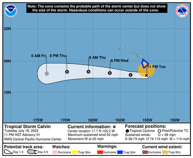
COURTESY CENTRAL PACIFIC HURRICANE CENTER
The 5-day forecast track for Calvin as of 11 p.m. Tuesday.

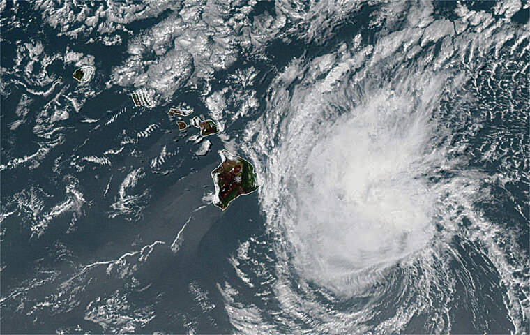
COURTESY NOAA
This color-enhanced satellite image shows Tropical Storm Calvin just west of Hawaii island Tuesday evening.

COURTESY NOAA
This daytime satellite image shows the position of Tropical Storm Calvin at 1:50 p.m.


UPDATE: 11:30 p.m.
Tropical Storm Calvin weakened late Tuesday night as it started passing just south of Hawaii island, bringing heavy rain, flash flooding, dangerous surf and damaging winds throughout the island.
At 11 p.m., Calvin had 50 mph maximum sustained winds, down 10 mph from just hours earlier, and was centered 140 miles south of Hilo and 305 miles southeast of Honolulu, moving west at 20 mph, according to the Central Pacific Hurricane Center. Tropical storm-force winds extend up to 140 miles from the center.
A tropical storm warning is effect for Hawaii island and its surrounding waters into Wednesday morning.
“Tropical storm conditions are imminent or occurring within the warning area this evening,” CPHC forecasters said. “Preparations for tropical storm force wind impacts should already be completed for persons in Hawaii County. Seek shelter.”
The center said total rainfall amounts through Thursday from Calvin are expected to be 4 to 8 inches, with maximum amounts of 10 inches possible, mainly along the windward slopes and southeast flank of the Big Island. Storm total rainfall amounts of 3 to 6 inches are expected for windward areas of Maui, and 2-4 inches elsewhere in the state. “This rainfall could lead to localized flash flooding and mudslides,” CPHC said.
Don't miss out on what's happening!
Stay in touch with breaking news, as it happens, conveniently in your email inbox. It's FREE!
>> RELATED STORIES:
Big Island schools, parks, more to close as Calvin nears
Hawaiian Airlines offers Big Island travel waiver due to Calvin Opens in a new tab
Even though Calvin is passing south of the Big Island, most of its main effects are being felt across the island.
The National Weather Service said, in addition to flooding rains, Calvin threatens:
>> Damaging winds overnight into Wednesday for the Big Island and Maui County, which may lead to power outages, downed trees and power lines, and impassable roads. Advisory-level winds are anticipated for Oahu and Kauai, especially through Wednesday as Calvin passes to the south.
>> Significant coastal impacts through Wednesday morning “along exposed east shores of the Big Island and Maui due to a combination of damaging onshore winds and life-threatening surf. Surf at this level combined with water levels running higher than predicted and surge associated with Calvin will produce significant beach erosion, with water potentially inundating vulnerable coastal areas and roadways. For Oahu and Kauai, expect the surf to rapidly build to advisory levels overnight, then remain up through the day Wednesday.”
Calvin’s latest five-day forecast track has it continuing to move west throughout Wednesday, well south of the rest of the island chain as it continues to weaken.”Vertical shear affecting the tropical cyclone is expected to be moderate through tonight and into Wednesday, then strong by Wednesday night. The strong shear should result in a weakening to post-tropical/remnant low status on Friday,” far to the southwest of the state, according to forecasters.
The National Weather Service has issued a host of other watches and advisories for Hawaii, including:
>> A flood watch through Wednesday afternoon for all Hawaiian islands.
>> A wind advisory until 6 p.m. Wednesday for Maui County, Oahu and Kauai. “The strongest winds will likely occur in areas over and downwind of terrain. … Northeast winds 25 to 35 mph with localized gusts of 55 mph expected.” The strongest winds will likely occur in areas over and downwind of terrain, forecasters said.
>> A high surf warning for the east shores of the Big Island and Maui County through 6 p.m. Wednesday. Surf may reach as high as 20 feet along the east shores of the Big Island, up to 15 feet along the east shores of Maui, and up to 12 feet along the east shores of the other islands, forecasters said.
>> A small craft advisory until 6 p.m. Wednesday for Kauai’s northwest, windward and leeward waters; Kauai Channel; and Oahu windward and leeward waters.
>> A gale warning for Maalaea Bay and Pailolo Channel until 6 p.m. Wednesday.
Beyond Wednesday, NWS forecasters said, “Calvin will likely weaken into a Tropical Depression by Thursday with breezy trade wind weather returning Thursday through the weekend.”
8 p.m.
The Central Pacific Hurricane Center said impacts from Calvin are “imminent” as the tropical storm continues to maintain its strength just 150 miles south-southeast of Hilo tonight.
At 8 p.m., CPHC said, Calvin was still packing 60 mph sustained maximum winds with higher gusts and moving west at a quick 21 mph. The storm was centered about 350 miles southeast of Honolulu. Tropical storm-force winds extend outward up to 140 miles from the center.
The tropical storm warning remains in effect for the Big Island.
“On the forecast track, tropical storm conditions are imminent and will spread over Hawaii County this evening,” CPHC’s latest update said. “Preparations for tropical storm force wind impacts should already be completed for persons in Hawaii County.”
A flood advisory has also been issued for portions of Hawaii island until 11:15 p.m.
“Heavy rain was falling at a rate of 1 to 2 inches per hour in some areas and increasing in coverage as Tropical Storm Calvin approaches from the east,” the advisory said. Locations that will experience flooding include Hilo, Hawaiian Paradise Park, Waikoloa Village, Kapaau, Honokaa, Pohakuloa Camp, Pohakuloa Training Area, Volcano, Glenwood, Mountain View, Hawaii Volcanoes National Park, Papaikou, Honomu, Pepeekeo, Wood Valley, Keaau, Hawaiian Acres, Laupahoehoe and Hakalau.
4:50 p.m.
Tropical Storm Calvin has maintained its strength as it marches toward Hawaii island, which should begin seeing tropical storm conditions starting this evening.
Just before 5 p.m., the Central Pacific Hurricane Center said Calvin still has maximum sustained winds of 60 mph with higher gusts and was located about 175 miles southeast of Hilo and about 385 miles southeast of Honolulu, moving west at 21 mph. Calvin is expected to continue in this general motion over the next few days. Tropical storm-force winds extend up to 140 miles from Calvin’s center.
A tropical storm warning is still in effect for Hawaii island, which means that tropical storm conditions are expected somewhere within the warning area.
Calvin is expected to remain as a tropical storm over the next 36 hours and then quickly weaken afterward, forecasters said. Hawaii island is expected to experience the greatest impacts, but strong winds, heavy rains and high surf along the eastern shores are forecast statewide.
“Now is the time to complete all preparations to protect life and property in accordance with your emergency plan. Ensure you are in a safe location before the onset of strong winds or possible flooding,” forecasters warned.
Total storm rainfall amounts have remained unchanged as forecasters predict 4-8 inches, with a maximum of 10 inches possible, mostly along the windward slopes and southeast flank of the Big Island. The windward areas of Maui are expected to see 3-6 inches of rainfall, while other areas of the state are forecast to get 2-4 inches of rainfall.
The National Weather Service said late this afternoon that sustained winds of 55 mph, and gusts of 70 mph, have already been reported at the summit of Mauna Kea. The road to the summit is closed.
High surf conditions generated by Calvin are expected to spread across the main Hawaiian islands tonight.
“This will lead to a rapid increase in surf along east-facing shores, with high surf continuing into Wednesday. This elevated surf will likely cause life-threatening conditions along exposed shorelines,” forecasters said.
2 p.m.
A tropical storm warning is still in effect for Hawaii County as Tropical Storm Calvin’s winds grew stronger while it approached Hawaii island.
Calvin is still forecast to weaken as it moves westward to the south of other Hawaiian Islands on Wednesday.
At 2 p.m., the Central Pacific Hurricane Center said Calvin had maximum sustained winds near 60 mph with higher gusts and was about 220 miles southeast of Hilo and 430 miles east-southeast of Honolulu. The storm was moving west at about 21 mph. Tropical-storm-force winds now extend up to 140 miles from the storm’s center.
Forecasters expect tropical storm conditions to begin this evening in the warning area.
Total rainfall amounts remain unchanged at 4-8 inches, with a maximum of 10 inches, expected today through Thursday mainly along the windward and southeast flank of the Big Island, forecasters said. Windward areas of Maui should see 3-6 inches, while the rest of the state is predicted to get 2-4 inches.
High surf is forecast along with wind and rain. Swells generated by Calvin are expected to spread across the island chain later today and tonight, with east-facing shores predicted to see a rapid increase in surf continuing into Wednesday, forecasters said.
“This elevated surf will likely cause life-threatening conditions along exposed shorelines,” forecasters warned.
The next update will be released at 5 p.m.
11 a.m.
Tropical Storm Calvin strengthened slightly this morning but is expected to weaken after it passes Hawaii County.
At 11 a.m., the Central Pacific Hurricane Center said Calvin had maximum sustained winds near 50 mph with higher gusts and was about 245 miles east-southeast of Hilo and 460 miles east-southeast from Honolulu, moving west at a quick 22 mph. Tropical-storm-force winds extend up to 115 miles from the center.
Calvin is forecast to pass over — or very near — Hawaii County tonight, bringing heavy rain, high surf and locally strong winds. The tropical storm “is expected to weaken as it moves westward to the south of the other Hawaiian islands Wednesday and Wednesday night,” officials said.
Storm total rainfall amounts of 4-8 inches, with maximum amounts of 10 inches are possible, mainly along the windward side of Hawaii island, forecasters said. Storm total rainfall amounts of 3-6 inches are expected in the windward areas of Maui. “Moderate rainfall flooding may prompt several evacuations and rescues,” officials said.
The rest of the state should see between 2-4 inches. The rainfall could lead to localized flash flooding and mudslides.
Calvin is expected to remain a tropical storm over the next 36 hours, weakening quickly afterward, forecasters said.
Hawaii island and its surrounding waters remain under a tropical storm warning.
Swells from Calvin will spread through the Hawaiian islands later today and tonight along east shores, causing life-threatening conditions along exposed shorelines, forecasters said.
The weather service has issued a host of other watches and advisories for Hawaii, including:
>> A flash flood watch for all Hawaiian islands through Wednesday afternoon.
>> A high surf warning for Maui County and the Big Island from this evening through Wednesday, with “dangerously large and disorganized waves of 10 to 15 feet.”
>> A wind advisory for Maui County through 6 p.m.
>> A high wind warning for Maui County through 6 p.m.
>> A wind advisory from 6 p.m. today through 6 p.m. Wednesday for Oahu and Kauai.
PREVIOUS COVERAGE
Tropical Storm Calvin maintained its strength overnight and is expected to deliver heavy rain and strong, gusty winds over Hawaii island later today and Wednesday.
At 5 a.m., the Central Pacific Hurricane Center said Calvin had maximum sustained winds near 45 mph with higher gusts and was about 390 miles east-southeast of Hilo and 605 miles from Honolulu, moving west at a quick 22 mph. Tropical-storm-force winds extend up to 105 miles from the center.
On its current forecast track, tropical storm conditions will likely begin spreading over Hawaii County starting this evening.
The latest five-day track has Tropical Storm Calvin passing near or over the southern tip of Hawaii island tonight into Wednesday morning, then moving westward as a weakening tropical storm with 40 mph sustained winds well south of the other islands. The storm is forecast to weaken to a tropical depression Thursday as it moves away from the state and dissipates Friday.
“Deep convection has been developing near Calvin early this morning, which may slow the weakening trend today,” forecasters said. “Calvin is forecast to gradually weaken from tonight through Thursday.
Hawaii island and its surrounding are under a tropical storm warning.
The National Weather Service said tropical storm force winds of 35 to 45 mph, with gusts to 65 mph, are expected on parts of the island from early this evening until Wednesday morning. “Remaining efforts to protect property should be completed as soon as possible. Prepare for limited wind damage,” officials said.
Residents should move to safe shelter before the wind becomes hazardous. The high winds could damage porches, awnings, carports, sheds, and mobile homes. Unsecured lightweight objects blown about, they said.
“A few roads impassable from debris, particularly within urban or heavily wooded places. Hazardous driving conditions on bridges and other elevated roadways,” officials said.
Storm total rainfall amounts of 4 to 8 inches are forecast into Thursday, with maximum amounts of 10 inches possible, mainly along the windward areas of the Big Island.
For the rest of the state, total rainfall amounts of 2 to 4 inches are expected.
Swells from Calvin will spread through the Hawaiian islands later today and tonight along east shores, causing life-threatening conditions along exposed shorelines, forecasters said.
The weather service has issued a host of other watches and advisories for Hawaii, including:
>> A flash flood watch for all Hawaiian islands through Wednesday afternoon.
>> A high surf warning for Maui County and the Big Island from this evening through Wednesday, with “dangerously large and disorganized waves of 10 to 15 feet.”
>> A wind advisory for the summit of Haleakala on Maui.


