Lava crosses access road, 2 new flows emerge from Mauna Loa

TOM KUALII / THEEDGEEXPLORER.COM / SPECIAL TO THE HONOLULU STAR-ADVERTISER
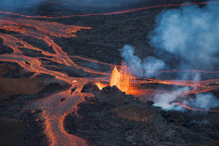
This view shows fountaining lava from the Mauna Loa eruption Tuesday morning.
TIM WRIGHT / SPECIAL TO THE STAR-ADVERTISER
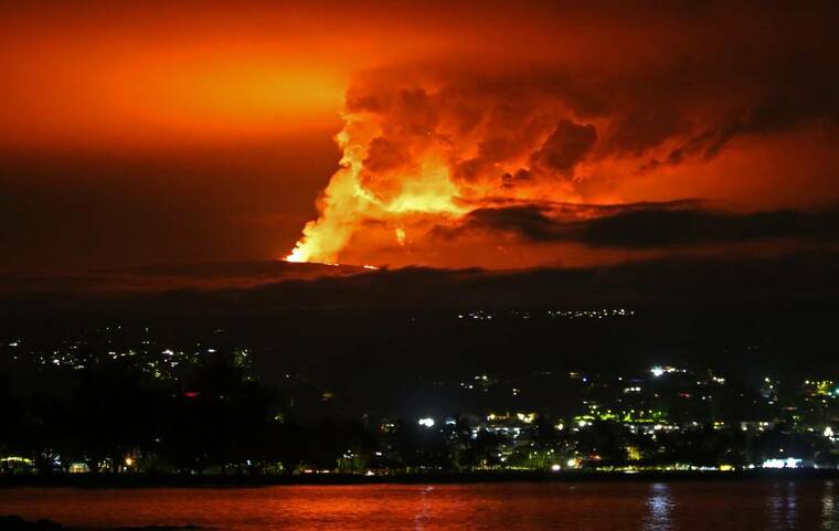
The Mauna Loa volcanic eruption on Hawaii island turned the night sky above the capital of Hilo reddish orange Monday night.
COURTESY DAVID FEE VIA USGS
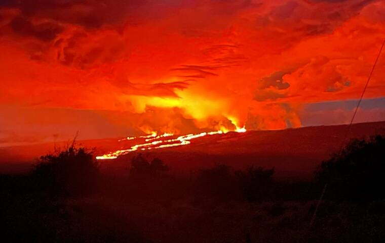
Lava is seen this morning flowing north-northeast at Mauna Loa.
COURTESY USGS
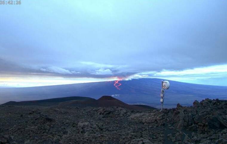
A screenshot from the Mauna Kea webcam shows a wide view of the Northeast Rift Zone this morning, today.
COURTESY USGS
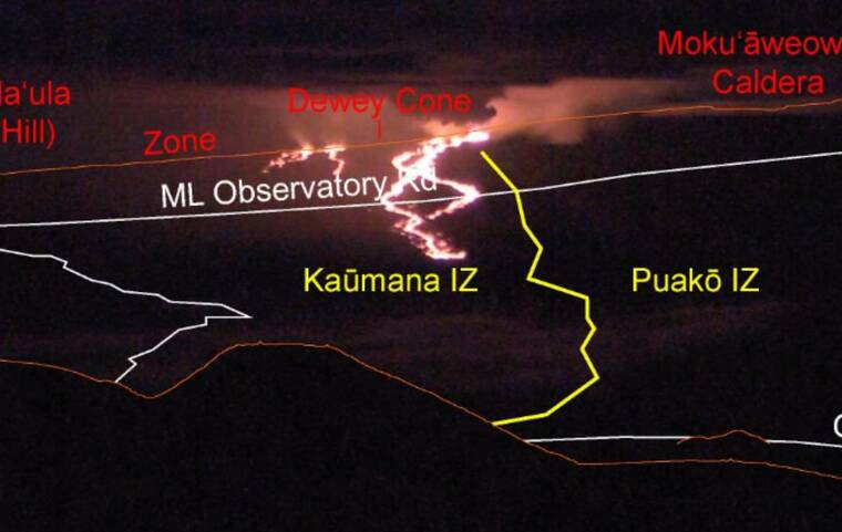
An annotated view from the webcam on Mauna Kea shows the lava flow from Mauna Loa’s Fissure 3 moving north across NOAA’s Mauna Loa’s Observatory road overnight.
COURTESY USGS / K. Lynn
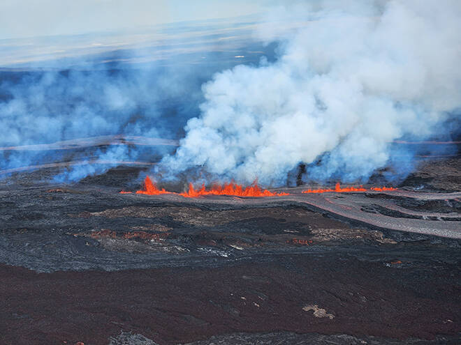
Lava fountains along a fissure on Mauna Loa’s northeast rift zone at about 9:30 a.m. on Monday.


UPDATE: 3:30 p.m.
Fissure No. 3 continues to remain active with fountains of lava between 50 and 100 feet high, according to scientists at the Hawaiian Volcano Observatory.
Lava from Fissure No. 4, a smaller fissure that opened Monday night, is feeding lava flows in the northeast direction but still miles away from Saddle Road. Lava from the smaller fissure spouted about 20 feet high this morning.
At a news briefing this morning, Scientist-in-Charge Ken Hon of the Hawaiian Volcano Observatory said they continue to monitor the flow and hope to have an effusion rate on the lava output soon.
Meanwhile, Gov. David Ige issued an emergency proclamation relating to Mauna Loa Monday night.
“We’re thankful the lava flow is not affecting residential areas at this time, allowing schools and businesses to remain open,” Ige said in a statement today. “I’m issuing this emergency proclamation now to allow responders to respond quickly or limit access, if necessary, as the eruption continues,” Ige said in a statement today.
Don't miss out on what's happening!
Stay in touch with breaking news, as it happens, conveniently in your email inbox. It's FREE!
Hawaii County Mayor Mitch Roth also issued an emergency rule Monday night prohibiting parking and traversing on Daniel K. Inouye Highway, also known as Saddle Road, and its shoulders between mile marker 16 and mile marker 31 due to the influx of spectators driving and parking on the highway.
“We understand that many of our residents and visitors are excited to view the tremendous eruption happening on the slopes of Mauna Loa; however, it must be done in a way that ensures the safety of all of our community,” Roth said in a statement today.
“Saddle Road presents a number of unsafe conditions for pedestrian traffic, including rain, fog, and other factors that can reduce visibility for oncoming traffic — especially at night. Therefore, we ask that all who seek to view the eruption do so in areas that are deemed safe and in accordance with the law,” he added.
Under the emergency rule, only county, state or federal government employees and verified governmental contractors will be allowed to park in the area.
The public may park at the Gilbert Kahele Recreational Area which will remain open 24 hours a day until further notice. Security guards will be on site from 6:15 p.m. to 6:15 a.m. daily.
Jessica Ferracane, spokeswoman of the Hawaii Volcanoes National Park, said several thousand people visited the park Monday to view the Mauna Loa eruption. Viewing areas along the Kilauea caldera before sunrise Monday revealed a massive glow from the Mauna Loa caldera and a smaller lava lake within Halemaumau at the summit of Kilauea.
“This is quite a sacred event,” Ferracane said of the rare dual eruption.
11:10 a.m.
Hawaii County Mayor Mitch Roth has issued an emergency order prohibiting parking from mile marker 16 to mile marker 31 on Daniel K. Inouye Highway, also known as Saddle Road.
Roth issued the rule Monday night in the wake of motorists parking along the highway to take photos and videos of the lava flow. “We’re telling people not to park on the highway.
“It’s a highway where cars go 60 miles an hour. It’s not a safe place to park,” said Roth in a phone interview with the Honolulu Star-Advertiser this morning.
Vehicles along the highway between mile marker 16 and mile marker 31 will be cited and towed.
People may park at designated areas along Saddle Road such as the Gil Kahele Recreation Area.
Meanwhile, lava from Fissure No. 3 remains active today while the two upper fissures became inactive around midday Monday, said Ken Hon, scientist-in-charge at the Hawaiian Volcano Observatory during a news briefing this morning on the eruption.
A smaller fissure also opened up slightly downrift of Fissure No. 3 Monday night.
Lava from Fissure No. 3 traveled down the slopes of Mauna Loa and crossed the Mauna Loa Observatory access road, cutting power and access to the NOAA Mauna Loa Observatory facility, Hon said.
The lava flow on Mauna Loa’s northeast flank remains at a high elevation of more than 9,000 feet.
Hon said the flow is about six miles from Saddle Road and is continuing to move downhill. “At about four miles from Saddle Road, it’s going to hit some flatter ground and presumably slow down considerably and the mode of movement may change as well,” he added. Right now, it’s a channelized flow traveling less than a mile per hour.
Not too many people use that access road at the point where the lava crossed over, Roth said.
The lava does not pose a threat to any communities. “We feel pretty optimistic right now that our communities are going to be safe,” Roth said.
Shelters that opened Monday at Old Kona Airport in Kailua-Kona and Kau Gymnasium in Pahala will close at noon today.
Gov. David Ige signed an emergency proclamation relating to the Mauna Loa eruption Monday night.
8:10 a.m.
Lava from the Mauna Loa eruption crossed the upper portion of the Mauna Loa access road Monday night, according to the Hawaii County Civil Defense Agency.
“The flow is currently 6 miles away from Saddle Road. It does not pose a threat to any communities at this time,” the agency said on its website this morning.
On Twitter, the U.S. Geological Survey Volcanoes posted an image showing the flow from Fissure No. 3 has moved north and crossed the road leading to the Mauna Loa Observatory. Two new flows are also moving north downrift of Fissure No. 3.
PREVIOUS COVERAGE
Mauna Loa’s first eruption in 34 years entered its second day today with Hawaii island residents and visitors reassured that the flowing lava posed no immediate risk to life or property.
All Hawaii public schools are open today on Hawaii island and, with the exception of Mauna Loa Access Road, no major roadway is closed or threatened by the northeast rift zone eruption.
State Department of Land and Natural Resources officials said late Monday that they have closed the Mauna Loa Forest Reserve and the Kipuka ‘Ainahou Nene Sanctuary for at least 90 days. Officials also closed Ainapo Trail and cabin, and the Kapapala Forest Reserve.
Seismic activity continued overnight with the U.S. Geological Survey reporting dozens of small earthquakes, most under magnitude 3.0, on the mountain. Separately, a 4.0 tremor shook the Pahala area on the southeast side of Hawaii island.
U.S. Geological Survey said Monday evening that the Mauna Loa eruption continued flowing along the northeast rift zone. Hawaii County Civil Defense Agency officials said the lava does not pose a threat to any communities or infrastructure at this time.
There are three fissures of lava with only the lowest remaining active as of 1:30 p.m. Fissure No. 3 is above 10,000 feet and more than 10 miles away from Saddle Road, officials said.
Shelters remained open overnight at Old Kona Airport in Kailua-Kona and Kau Gymnasium in Pahala as a precaution, but officials said there was no danger to residents along the southwest slopes of the mountain.
On Monday, Hawaii island Mayor Mitch Roth described the lava flow as heading in “the best possible” direction.
Although the flow is heading toward Hilo, the path’s topography and history of Mauna Loa eruptions put the city on the island’s east side far from danger.
”We feel pretty comfortable with the situation,” Roth said Monday. “Right now it seems like the lava is going to a positive place as far as keeping away from the public and everything like that — away from property.”
Ken Hon, scientist-in-charge of the USGS’ Hawaiian Volcano Observatory, said Monday afternoon that the eruption appeared similar to one from Mauna Loa in 1984 and that if the current flow is maintained, it could be about a week until it approaches the outskirts of Hilo.
County officials and scientists cautioned that Mauna Loa eruptions can be dynamic in early phases, so the public should pay attention to alerts.
By 1:30 p.m. Monday only one of the three fissures remained active, and most fountaining was only around 10 feet or so high, USGS reported.
County and HVO continue to caution that eruptions from Mauna Loa, the world’s largest volcano, can be unpredictable and long-lasting, and they recommend residents visit the county’s volcano hazards website Opens in a new tabfor more information and updates.
County of Hawaii Supplemental Emergency Proclamation on Mauna Loa Eruption by Honolulu Star-Advertiser on Scribd


