Hurricanes Erick, Flossie forecast to bring wet weather for all islands


CENTRAL PACIFIC HURRICANE CENTER
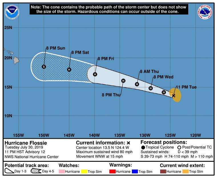
Hurricane Flossie’s five-day forecast as of 11 p.m. Tuesday.


UPDATE: 11 p.m.
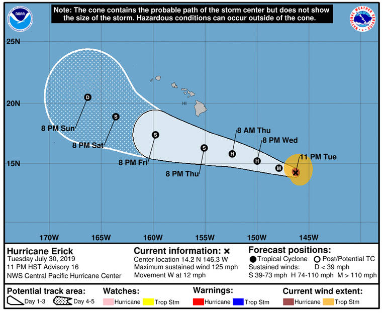
Hurricane Erick has downgraded to a Category 3 hurricane and is expected to continue weakening as it approaches Hawaii from the east.
The National Weather Service reported Erick about 695 miles east-southeast of Hilo and 905 miles east-southeast of Honolulu.
Erick, with winds near 125 mph, is moving toward the west near 12 mph.
Weather officials said to expect wet weather conditions spreading from east to west across all islands, from Thursday into the weekend, as the center of the storm passes just south of the Big Island on Friday.
Hurricane-force winds extend outward up to 30 miles from the center and tropical-storm-force winds extend outward up to 125 miles.
Don't miss out on what's happening!
Stay in touch with breaking news, as it happens, conveniently in your email inbox. It's FREE!
Hurricane Flossie is also expected to potentially bring more weather impacts to the islands as it moves closer.
Flossie, with winds near 80 mph, is 2,075 miles east of Hilo, moving toward the west-northwest near 15 mph.
This general motion is expected to continue through Friday, and some strengthening is possible during the next few days.
Hurricane-force winds extend outward up to 30 miles to the northeast of the center, and tropical-storm-force winds extend outward up to 105 miles from the center.
5 p.m.
Hurricane Erick is expected to weaken but bring potentially dangerous surf later this week, according to the Central Pacific Hurricane Center.
The Category 4 Erick, with maximum sustained winds near 130 mph, is 750 miles east-southeast of Hilo and 965 miles east-southeast of Honolulu. It is moving toward the west-northwest near 15 mph and this general motion is expected to continue for the next several days.
Steady weakening is expected to start Wednesday followed by rapid weakening Thursday and Friday.
Swells generated by Erick will arrive in the islands over the next couple of days with potentially dangerous surf conditions along east-facing shores.
Meanwhile, Hurricane Flossie is gradually strengthening in the East Pacific. Flossie, with winds near 80 mph, is 1,085 miles southwest of the southern tip of Baja California. Slow strengthening is expected during the next few days.
2 p.m.
Gov. David Ige said Hawaii can expect possible heavy winds and rains from Hurricane Erick as it moves south of the islands this weekend.
At a news conference to discuss the standoff on Mauna Kea, Ige expressed concern for the protesters’ and law enforcement officers’ safety on the mountain as two tropical cyclones approach the islands.
Hurricane Erick, now a Category 4 storm in the Central Pacific with 130 mph winds, is expected to weaken to a tropical storm by this weekend.
Further east, but potentially a bigger threat to Hawaii, Hurricane Flossie in the East Pacific is projected to move closer to the islands on a more northerly track.
Ige said Flossie “tracks north of the islands and certainly that is a bigger concern for us. It seems there might be more significant impacts weather-wise in the islands.”
He said he was considering emergency proclamations for the state as the storms move closer.
PREVIOUS COVERAGE
11 a.m.
Flossie has become a hurricane in the East Pacific on the heels of now-Category 4 Hurricane Erick which is in the Central Pacific and headed on a path that would bring it south of the Hawaiian islands.
The National Hurricane Center said Flossie had maximum sustained winds of 75 mph, moving west at 14 mph and was 1,045 miles southwest of the southern tip of Baja California at 11 a.m. today.
Additional strengthening is expected during the next few days, forecasters said, adding that hurricane-force winds extend outward up to 25 miles from the center and tropical storm-force winds extend up to 80 miles.
”The cyclone is expected to be in generally favorable environmental conditions to strengthen during the next day or so,” the hurricane center in Miami said today. “After that time, however, the sea surface temperatures beneath the hurricane gradually decrease and the wind shear is expected to increase a little. A combination of these factors should end the strengthening trend and induce a slow weakening by the weekend.”
At the end of the current five-day forecast, Flossie is projected to be several hundred miles west-southeast of Hilo on a northwesterly track. If it continues on this path, Flossie could be affecting Hawaii’s weather by early next week.
Hurricane Erick, meanwhile, intensified into a Category 4 storm this morning with maximum sustained winds of 130 mph. Erick was located 840 miles east-southeast of Hilo and 1,050 miles east-southeast of Honolulu, and was moving west at 15 mph at 11 a.m., according to the Central Pacific Hurricane Center.
However, the five-day forecast has Erick weakening to tropical storm strength as it passes south of the islands this weekend.
No Hawaiian island is in the current so-called “cone of uncertainty” forecast, but forecasters warn that the storm can still bring heavy rains and high surf to the islands.
The hurricane center in Honolulu warns that swells generated by Erick will reach Hawaii shores “over the next couple of days, potentially producing dangerous surf conditions, mainly along east facing shores.”
5 a.m.
Hurricane Erick intensified to a major hurricane today as it continued its march toward the islands.
Packing maximum sustained winds of 115 mph as of 5 a.m. today, the center of Erick was located 920 miles east-southeast of Hilo and 1,135 miles east-southeast of Honolulu and headed west at 17 mph, according to the Central Pacific Hurricane Center.
Now a Category 3 hurricane, CPHC officials expect Erick to strengthen further later today. However, by Wednesday, gradual weakening is possible, with a more rapid weakening trend expected on Thursday.
A turn toward the west-northwest at a slightly slower forward speed is also expected later today. The west-northwest motion is forecast to continue through Thursday.
Hurricane-force winds extend outward up to 25 miles from Erick’s center and tropical-storm-force winds extend outward up to 105 miles.
Meanwhile, Tropical Storm Flossie continues to gain strength and is expected to become a hurricane later today.
With its center located about 2,347 miles east-southeast of Hilo as of 5 a.m., Flossie was packing maximum sustained winds of 70 mph while moving west at 15 mph, according to the National Hurricane Center.
Flossie is expected to become a hurricane later today and could be near major hurricane strength by Thursday, according to the NHC.
The tropical storm is forecast to turn toward the west-northwest later today, and then continue moving west-northwestward at 15 to 20 mph through the end of the week.
Tropical-storm-force winds extend outward up to 80 miles from Flossie’s center.


