Latest updates: Tropical storm warning canceled for Oahu, Maui

JAMM AQUINO / JAQUINO@STARADVERTISER.COM
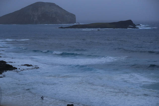
A bodyboarders braves leftover storm surge and waves from Tropical Storm Lane at Makapuu Beach on Saturday, Aug. 25.
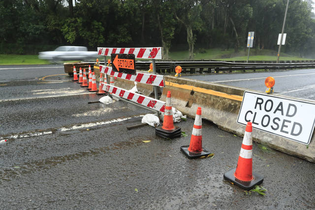
JAMM AQUINO / JAQUINO@STARADVERTISER.COM
Kailua-bound Pali Highway remains closed this morning Saturday, Aug. 25.
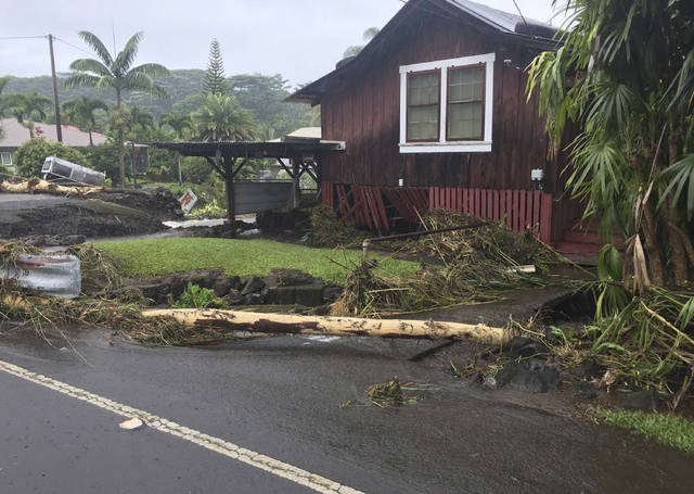
ASSOCIATED PRESS
This photo provided by Jessica Henricks shows damage from Hurricane Lane on Friday near Hilo, Hawaii. Hurricane Lane barreled toward Hawaii, dumping torrential rains that inundated the Big isle’s main city as people elsewhere stocked up on supplies and piled sandbags to shield oceanfront businesses against the increasingly violent surf. The city of Hilo, population 43,000, was flooded with waist-high water.
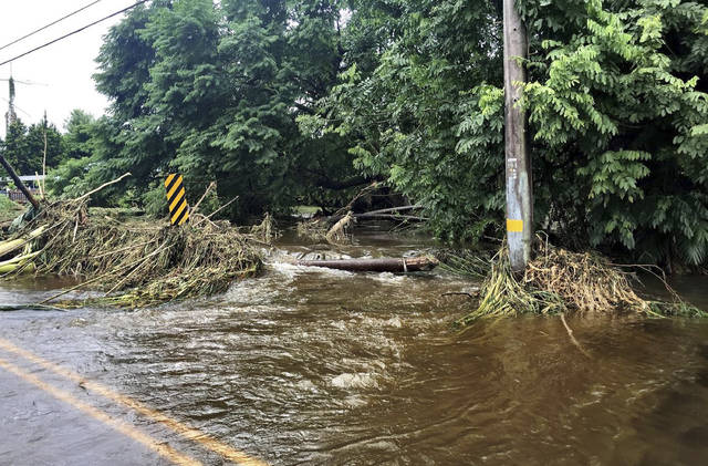
ASSOCIATED PRESS
In this photo provided by Jessica Henricks, is flooding and damage from Hurricane Lane on Friday near Hilo, Hawaii. Hurricane Lane barreled toward Hawaii on Friday, dumping torrential rains that inundated the Big isle’s main city as people elsewhere stocked up on supplies and piled sandbags to shield oceanfront businesses against the increasingly violent surf. The city of Hilo, population 43,000, was flooded with waist-high water.
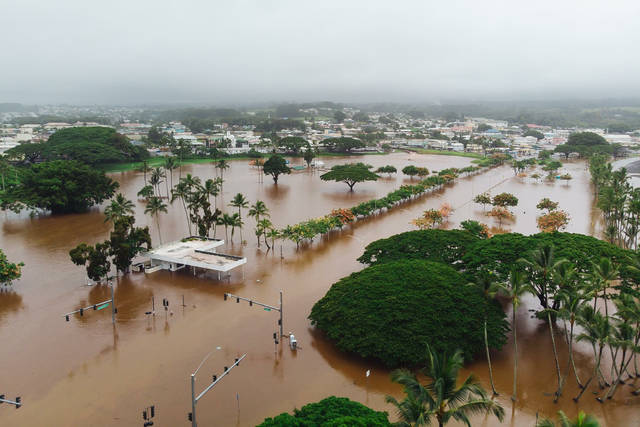
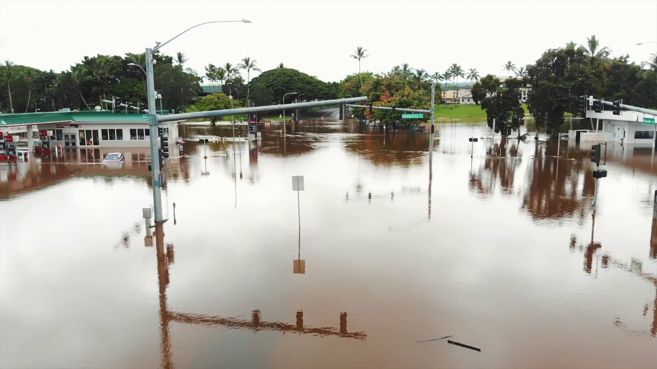
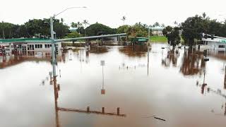
COURTESY TRACEY NIIMI
Drone footage provided by Tracey Niimi showed flooding at Pauahi Street and Kamehameha Avenue in Hilo near Bayfront Highway. Rain from Hurricane Lane flooded parts of the Big isle.


Click here for the latest updates on Tropical Storm Lane. Opens in a new tab
UPDATE: 11:15 a.m.
A tropical storm warning has been canceled for Oahu and Maui, and a tropical storm watch has been canceled for Kauai, the National Weather Service said.
Tropical Storm Lane is moving westward at about 7 mph and is expected to pick up speed. It is expected to pass about 150 miles south of Kauai today.
The storm has maximum sustained winds of about 50 mph with higher gusts and tropical-storm-force winds reaching outward up to 100 miles.
It is about 145 miles southwest of Honolulu.
Don't miss out on what's happening!
Stay in touch with breaking news, as it happens, conveniently in your email inbox. It's FREE!
The weather service said lingering moisture from the storm is expected to produce additional flash flooding and landslides, with additional amounts of 5 to 10 inches of rain across the windward side of Hawaii island and Maui and 3 to 5 inches elsewhere.
10:47 a.m.
The National Weather Service issued a flash flood alert for all Hawaiian islands from now until later tonight.
A flash flood watch is now in effect for Oahu, Hawaii island, Kauai, Lanai, Maui, Molokai and Niihau.
Hawaii residents should prepare for heavy rainfall, including amounts greater than 20 inches in some areas.
Avoid crossing fast-flowing water, the alert warned. “Monitor later forecasts and be prepared to take action should flash flood warnings be issued. If you experience heavy rain or rising water, head to higher ground immediately,” NWS said.
5 a.m. today
The National Weather Service Central Pacific Hurricane Center this morning canceled the tropical storm warning for Hawaii island, but the island continued to be under a flash flood warning.
Hawaii island, which struggled with enormous rainfall on the windward side of the island, continued to see heavy rain this morning. The tropical storm warning remained in effect for Oahu and Maui counties. Kauai county was still under a tropical storm watch.
Tropical Storm Lane was located about 110 miles south-southwest of Honolulu and about 165 miles south-southeast of Lihue, according to NWS. Lane was moving slowly at about 3 mph to the south of the western Hawaiian isles with maximum sustained winds of 60 mph with higher gusts.
Forecasters said the motion would continue through this morning, followed by a turn toward the west later today or tonight. “On the forecast track, the center of Lane will pass south of Kauai and Niihau later today and tonight,” the forecast said.
Tropical storm-force winds extend outward up to 125 miles from Lane’s eye. “Tropical storm conditions are still expected in and near outer rain bands that will affect Oahu and Maui County today,” the forecast said. Starting later today, Kauai residents may also see tropical storm conditions.
The forecast warned of excessive rainfall this weekend, which could lead to flash flooding and landslides. Some areas may receive 5 to 10 inches of rain. “Remain well guarded against life-threatening flood waters having possible extensive to devastating impacts,” the NWS said.
All major highways reopened on Big isle, including both lanes of Highway 11 in the Kawa area. The Hawaii Police Department warned Hawaii island residents to drive carefully and be on the alert for debris, potholes and water ponding on roads.
A high surf advisory remained in effect for south- and east-facing shores of all islands.
PREVIOUS COVERAGE
Saturday 2:30 a.m.
Tropical Storm Lane, with maximum sustained winds of 65 mph, was 130 miles south-southwest of Honolulu and 185 miles south-southeast of Lihue, moving north-northwest at about 3 mph.
The Central Pacific Hurricane Center said this general motion is expected to continue through this morning, followed by a turn toward the west later today or tonight. “On the forecast track, the center of Lane will pass south of Kauai and Niihau later today,” forecasters said.
A tropical storm warning remains in effect for Oahu, Maui County and Hawaii island, while Kauai County is under a tropical storm watch.
Tropical storm-force winds, of 39 mph or more, extend up to 130 miles from Lane’s center.
The Big Island, which has been the hardest hit by Lane, was also under a flash flood warning until 5:30 a.m. as heavy rainfall continued overnight in the Kau and Puna districts, causing extreme flooding, according to the National Weather Service.
“This is a very dangerous situation. Do not travel due to ongoing flood impacts,” the warning said.
A flash flood watch remained in effect for the entire state through this afternoon. A high surf advisory is in effect for the south- and east-facing shores of all islands until 6 a.m.
12:20 a.m.
The flash flood warning for the Big Island has been extended until 2:30 a.m. Saturday.
At 11:35 p.m., the National Weather Service reported extremely heavy rainfall persisting over the Kau and Puna Districts, with rates of 2 to 3 inches per hour. This has been ongoing for several hours and extreme flooding impacts are being reported by the Civil Defense.
Numerous road closures are in place including Highway 11 between Keeau and Hawaiian Paradise park, near Pahala at Kawa Flats, and on portions of Saddle Road.
Friday 11 p.m.
Tropical Storm Lane continues to flood the Big Island, prompting a number of road closures due to landslides and debris.
The Hawaii Police Department is advising residents to stay off all roadways due to the hazardous conditions. Crews are not able to open them at this time.
The Central Pacific Hurricane Center tracks Lane moving north-northwest near 3 mph south of the islands. The tropical storm was last located about 135 miles south-southwest of Honolulu and about 190 miles south-southeast of Lihue.
Forecasters said Lane is expected to turn westward beginning Saturday when it will pass south of Kauai and Niihau.
Maximum sustained winds are near 65 mph with higher gusts. Tropical-storm-force winds extend outward up to 130 miles from the center. Additional weakening is forecast through this weekend, and Lane may become a remnant low by Sunday.
Lane has dumped nearly 3 feet of rain on parts of the Big Island over the past couple of days, forcing residents to flee their homes in waist-high water.
Honolulu Mayor Kirk Caldwell said people need to be vigilant and not let their guard down. But he was happy to hear the storm deteriorated.
“The good news is Lane got weak and fell apart. We dodged a bullet,” he said at a news conference today.
Federal Emergency Management Agency officials said about 2,000 people were in shelters, mostly in Oahu. Honolulu’s shelters would stay open until midday Saturday, Caldwell said.
On Moloaki, a flood advisory is in effect until midnight, as moderate to heavy rain falls at rates of 1 to 2 inches per hour, leading to “localized nuisance flooding,” forecasters said.
8:50 p.m.
Tropical Storm Lane is nearly stationary and bringing rain and damaging winds to parts of the islands, said National Weather Service forecaster Tom Birchard.
He said the storm is in the same place it was four hours earlier with the same maximum sustained winds of about 70 mph. The center is about 150 miles south-southwest of Honolulu.
Lane is forecast to continue “wobbling” around close to the islands tonight and turn toward the west on Saturday, Birchard said.
Meanwhile, heavy rain continued falling on the Big Island with rates of 4 inches per hour at about 8:50 p.m., the weather service said.
A flash flood warning for the entire island has been extended to 11:45 p.m.
Hawaii County Civil Defense urged residents to stay off all roadways and said flooding, landslides, and debris were causing multiple road closures.
“Police report extremely dangerous driving conditions throughout the island,” a Civil Defense statement said.
Civil Defense noted that sandbags cannot be distributed because crews were responding to life-saving tasks.
8:20 p.m.
A flash flood warning for Maui has been extended to 11:15 p.m. today.
The National Weather Service said heavy rain was falling over the slopes of Haleakala, while torrential rainfall was occurring from Hookipa to Keanae to Hana to Kaupo.
Hana Highway is closed near mile marker 20 and Piilani Highway is closed near Kaupo.
“Additional road closures are likely, as rainfall rates of 2 to 3 inches per hour are stationary over the slopes of windward Haleakala, and over the windward slopes of west Maui,” the weather service said.
7:45 p.m.
Hawaii island continues to be inundated with rain from Tropical Storm Lane tonight and flooding has closed a major roadway in Puna.
Hawaii Civil Defense reported Route 130 from Keeau High School to Hawaiian Paradise Park is closed due to flooding.
The National Weather Service has extended a flash flood warning for the island to 9:30 p.m. today.
“Additional flooding will likely result in more road closures, especially in the Puna and Kau Districts,” the weather service said.
6:35 p.m.
Hawaii island is under a flash flood warning as Tropical Storm Lane continues to hammer the island with rainfall.
At about 6:25 p.m., radar was showing intense rainfall over the southeast and east side of the island, from Kohala to Mountain View to Pahala, the National Weather Service. Rain was reported to be falling at 4 inches per hour.
“This will causes streams and drainages to rise rapidly, especially (in) South Hilo and Puna Districts,” the weather service said before adding in capital letters: “This is a very dangerous situation. Avoid unnecessary travel due to ongoing flood impacts.”
Locations in the warning include: Hilo, Paauilo, Waipio Valley, Hawi, Pepeekeo, Keaau, Honokaa, Ookala, Hawaiian Paradise Park, Mountain View, Pahoa, and Naalehu.
5:45 p.m.
The National Weather Service has issued a flash flood warning for Maui after heavy downpours were seen on the slopes of Haleakala.
At about 5:15 p.m., radar showed rain falling at 1 to 3 inches per hour with heavy rainfall spreading into the West Maui Mountains.
The warning is set to expire at 8:15 p.m. The warning includes, but is not limited to, these locations: Kahului, Honokohau, Kahakuloa, Haliimaile, Paia, Makawao, Wailuku, Waihee, Kaanapali, Kula, Keanae, Nahiku, and Pukalani.
4:50 p.m.
Lane is now a tropical storm, forecasters said just before 5 p.m., with sustained winds of 70 mph.
Oahu and Maui County are now under a tropical storm warning, downgraded from a hurricane warning as Lane continued to fall apart just south of the islands. Hawaii island remains under a tropical storm warning and Kauai remains under a tropical storm watch.
The storm was centered about 250 miles south-southwest of Honolulu and 160 miles west of Kailua-Kona. Tropical storm-force winds extend outward up to 140 miles from the center.
The Central Pacific Hurricane Center cautioned that rain bands will still bring more flooding and damaging winds to parts of the main Hawaiian islands.
“Lane is now moving toward the northwest near 3 mph and this motion is expected to become more westerly with an increase in forward speed over the next couple of days. On the forecast track, the center of Lane will pass south of Kauai on Saturday,” they said. “Additional weakening is forecast during the next 48 hours, and Lane may become a remnant low later Saturday or Sunday.”
The hurricane’s demise is a remarkable change in intensity. The storm had maximum sustained winds of 120 mph just 24 hours ago, making it a major hurricane. On Tuesday, it peaked as a Category 5 storm with winds of 160 mph.
4:33 p.m.
Hurricane Lane has produced torrential rainfall along the Big Island’s windward side, from Hawi on the North Shore to Naalehu on the south side.
Here are some significant rainfall totals in inches from the Big Island reported by the National Weather Service over a 48-hour period ending at noon today:
>> Waiakea Uka : 35.51
>> Piihonua : 34.86
>> Saddle Quarry (USGS) : 34.83
>> Waiakea experiment station : 28.82
>> Papaikou well : 26.88
>> Mountain View : 26.64
>> Kulani NWR : 18.97
>> Glenwood : 17.53
>> Keaumo : 14.47
>> Kawainui Stream (USGS) : 13.40
>> Puu Mali : 11.27
>> Pahoa : 10.97
3:45 p.m.
A flash flood warning has been extended for the Big Island to 6:30 p.m.
Radar showed heavy rain falling at about 3:35 p.m. from the Hamakua District to the Kau District, the National Weather Service said.
Rain has been falling at about 1 to 2 inches per hour recently, the weather service said.
Residents should avoid unnecessary travel because of ongoing flooding.
3:00 p.m.
The National Weather Service has extended a flash flood warning for Maui to 5:45 p.m. as radar showed downpours spreading along the windward slopes.
The Hana area is especially vulnerable to flash flooding because the ground is already saturated from Thursday’s heavy rainfall, the weather service said.
Piilani Highway remains closed on the south side of Haleakala near Kaupo.
2:28 p.m.
A flash flood warning has been issued for island of Maui until 5:00 p.m.
“At 2:06 p.m., radar showed persistent localized rainfall along the south facing slope of Haleakala. Maui County emergency management reported that Piilani Highway is closed near Kaupo. Other low water crossings will be at risk for flooding from mile marker 30 to Kalepa Gulch,” the warning said. Locations in the warning include Kaupo, Kipahulu and Keokea.
1:53 p.m.
Hurricane Lane has weakened significantly over the past few hours to a Category 1 storm and that rapid weakening is expected to continue over the next two days, the National Weather Service said.
The hurricane has slowed to about 2 mph and was about 120 miles south of Honolulu, but it is now moving to the north-northeast. The general motion expected to continue into tonight, followed by a sharp turn to the west.
Maximum sustained winds are about 85 mph with higher gusts — a 20 mph drop from the 11 a.m. update. Hurricane-force winds extend outward up to 25 miles from the center, while tropical-storm-force winds extend outward up to 140 miles, the weather service said.
Forecasters expect the hurricane to turn toward the west and increase in speed on Saturday. In 12 hours, Lane is expected to be a tropical storm with maximum sustained winds of 70 mph.
Still, forecasters warn, “One should not interpret the forecast westward turn south of the islands as a lower threat to the islands. If Lane retains central core convection longer than anticipated, the westward turn would happen later, which could bring hurricane conditions to Maui County or Oahu. This solution is still plausible at this time. Regardless of whether Lane makes landfall, severe impacts are still possible and the effects can extend far to the north and east of the center of Lane.”
1:40 p.m.
President Donald Trump called Gov. David Ige to offer the federal government’s full support to Hawaii as Hurricane Lane marches alongside the islands.
At a joint midday news conference at the state’s Emergency Operations Center, Ige said he thanked the president for the responsiveness of the Federal Emergency Management Agency and other federal departments.
As Lane continues to dump rain on the Big Island and Maui, and threatens Oahu with the same, Ige urged residents and tourists to heed all warnings given by civil defense on each island.
Honolulu Mayor Kirk Caldwell added, “Lane is in the slow lane and doesn’t want to go away.” Caldwell said that about 1,100 people so far have taken advantage of the 20 emergency shelters on the island.
He said city officials are very concerned and are preparing for the worst, especially after seeing how much rain Lane has dumped on Hawaii island.
National Weather Service meteorologist Leigh Anne Eaton said parts of the northeastern side of the Big Island have received up to 36 inches of rain since the start of Lane’s onslaught earlier this week. Other areas of the island have received more than a foot of rain thanks to the nearly stalled storm.
11 a.m.
As its forward speed has increased, Lane remains a strong Category 2 hurricane on track toward Oahu.
Located about 150 miles south of Honolulu and 130 miles west-southwest of Kailua-Kona at 11 a.m., Lane was heading north toward Oahu at 5 mph with maximum sustained winds of 105 mph, according to the Central Pacific Hurricane Center. Hurricane-force winds extend outward up to 35 miles from Lane’s center and tropical-storm-force winds extend outward up to 140 miles.
Weather officials expect Lane to weaken to a Category 1 hurricane around the time it’s forecast to turn west Saturday morning.
Kauai is now under a tropical storm watch, instead of a hurricane watch.
Approximately 3,500 Coast Guard members across the main Hawaiian islands are staged and ready to respond to meet the needs of the public as they brace for Hurricane Lane, said Petty Officer 3rd Class Amanda Levasseur.
Three H-65 Dolphin helicopters, two fixed-wing aircraft, six cutters and 22 small boats are also on standby.
UPDATE: 9:55 a.m.
U.S. Secretary of Defense James N. Mattis has approved Gov. David Ige request to form the Dual-Status Command, Joint Task Force 50 to coordinate the federal and state military response to hurricane relief efforts.
The formation of JTF-50 establishes a clear chain of command to maintain operational unity between state and federal efforts and increase efficiency, a state news release said.
Brig. Gen. Kenneth Hara, state deputy adjutant and commander of the Hawaii Army National Guard, now has the authority to command both the National Guard and active military forces to plan and execute relief efforts, such as clearing vital roadways or conducting mass air evacuations, the state said.
“Our federal partners have been quick to respond to our requests for assistance in the face of Hurricane Lane, and I thank Secretary Mattis for his speedy approval. This joint military task force will provide the necessary state and federal resources to any county in Hawaiʻi that needs assistance. Together, we are committed to supporting the residents of Hawaii in their time of need,” said Ige in the release.
Hara will oversee a joint Hawaii National Guard and active duty military joint task force, which may include search and rescue, debris clearance, security, and emergency evacuations.
According to the state, the dual status commander is a legally authorized military officer who assumes command authority over both National Guard forces and Title 10 federal military forces.
9 a.m.
The Honolulu Fire Department responded to six reports of roofs blown off homes— two in Nanakuli and Kalihi and one in Aina Haina and Makiki — between 8 p.m Thursday and 6:30 a.m. today.
Honolulu Fire Spokesman Scot Seguirant said no injuries were reported.
Firefighters also responded to reports of downed power lines at the 87-1640 block of Nanakuli, and 4975 Keia Place in Ewa Beach.
Thousands of Hawaiian Electric customers, meanwhile, have experienced power outages statewide.
Spokesman Peter Rosegg said some 280 customers have experienced outages on Oahu; 6,000 customers on Maui; 4,500 customers on Hawaii island; and 2,600 customers on Molokai.
“We’re working to get those fixed as quickly as we can,” Rosegg said.
Should conditions worsen, he noted crews may have to hunker down and roll out when conditions are safe.
Rosegg encouraged customers to report any outages via the Hawaiian Electric mobile app that is available at the online Apple store or Google Play.
UPDATE: 8:14 a.m.
Still a strong Category 2 hurricane, Lane has weakened slightly since 5 a.m., but still remains on a course toward Oahu.
Packing maximum sustained winds of 105 mph, Lane was located about 170 miles south of Honolulu and 140 miles west-southwest of Kailua-Kona at 8 a.m., and heading north at a leisurely 2 mph, according to the Central Pacific Hurricane Center.
Lane is expected to continue on this course through tonight, turning west Saturday while gaining forward speed, weather officials said.
Hurricane-force winds extend outward up to 35 miles from Lane’s center and tropical-storm-force winds extend outward up to 140 miles.
7:55 a.m.
More residents have sought shelter at emergency shelters set up on Oahu as they brace for Hurricane Lane.
There are approximately 1,100 evacuees at 20 shelters set up by the American Red Cross Hawaii chapter as of 11 p.m. Thursday, according to John Cummings III, spokesman of the Hawaii Emergency Management Agency.
Gusty winds have already begun to wreak havoc on roadways and residential neighborhoods overnight with blown roofs and downed trees and branches.
>> Star-Advertiser Hurricane Tracker
>> Some shopping malls closing early due to Hurricane Lane
>> Flood risk rises in East Hawaii as Hurricane Lane stalls
>> Major thoroughfares on Oahu, Big Isle, Kauai closing due to Lane
>> HECO expects Lane will prompt power outages
>> Airlines issue travel waivers for passengers
>> Last-minute shopping a challenge
>> Mayor says slow-moving storm could cause major problems
>> How to pack a disaster preparedness kit
VIDEO:
>> Pi‘ihonua Bridge in Kaumana hit with flooding from Hurricane Lane
>> Weather Channel hurricane expert has a message for residents of Hawaii
>> Hawaii residents stock up on supplies ahead of Hurricane Lane
PHOTOS:
>> Hurricane Lane causes flooding on Hawaii island
>> Hawaii residents prepare for arrival of Hurricane Lane Opens in a new tab
Cummings said they received reports of blown roofs of two homes in Nanakuli. No injuries were reported.
Downed trees were also reported in Pupukea and Mililani as well as dangling tree branches on Wilder Avenue and the School Street offramp.
Downed tree branches also blocked a section of Tantalus Drive at about 5:30 a.m. today.
6:55 a.m.
The National Weather Service stressed to the public to remain vigilant despite Hurricane Lane being downgraded to a Category 2.
“It’s still a dangerous storm,” said forecaster Melissa Dye adding flash flooding, high surf and gusty winds are huge concerns.
Rain gauges showed rainfall on Hawaii island has surged over the east side of the island from Honomu to lower Puna with rates of one to two inches per hour.
Dye said the windward side of the Big Island has seen approximately 30 inches of rain over the past 36 hours.
“Hurricane Lane continues to approach the central Hawaiian Islands, so there is no reason to believe that anyone is safe in the warning area,” the National Weather Service said in a bulletin.
On Oahu, wind gusts were reported along the Leeward areas. Gusts at the Daniel K. International Airport were at 43 miles per hour.
PREVIOUS COVERAGE
Although Lane has been downgraded to a Category 2 hurricane, it still remains an extremely dangerous storm headed north toward Oahu.
Packing maximum sustained winds of 110 mph and located about 180 miles south of Honolulu and 145 miles west-southwest of Kailua-Kona, Lane was headed north at 5 mph at 5 a.m. today, according to the Central Pacific Hurricane Center.
A hurricane warning remains in effect for Oahu and Maui County.
Hurricane-force winds extend outward up to 35 miles from Lane’s center and tropical-storm-force winds extend outward up to 140 miles.
2 a.m.
Hurricane Lane is still headed north toward Oahu as a major hurricane as “catastrophic flooding” is occurring on Hawaii island.
Located about 160 miles southwest of Kailua and 200 miles south of Honolulu, Lane was still packing maximum sustained winds of 120 mph and headed north at a leisurely 5 mph at 2 a.m., according to the Central Pacific Hurricane Center.
Although weather officials still expect Lane to turn west, that change in direction is not forecast to happen until Saturday. “The center of Lane will move over, or dangerously close to portions of the main Hawaiian Islands later today and tonight,” the CPHC said in a bulletin.
Hurricane-force winds extend outward up to 35 miles from Lane’s center and tropical-storm-force winds extend outward up to 125 miles.
Although Hawaii island is now under a tropical storm warning instead of a hurricane warning, the island is still under a flash flood warning until 6:45 a.m. with some areas having been inundated with over 20 inches of rain in the last 24 hours.
Rain gages in Hakalau registered 23.61 inches in the last 24 hours while Saddle Quarry registered 22.75 inches.
11 p.m.
Hurricane Lane continues to move north near 6 mph and has dumped nearly 2 feet of rain on the Big Island.
In the latest update, the Central Pacific Hurricane Center reported Lane moving 165 miles southwest of Kailua-Kona and 345 miles south of Honolulu.
Lane is still forecast to move dangerously close to portions of the Hawaiian Islands late Friday.
Maximum sustained winds are near 120 mph with higher gusts. Hurricane-force winds extend outward up to 35 miles from the center and tropical-storm-force winds extend outward up to 125 miles.
At 10:45 p.m., heavy rain was reported along the windward sections of the Big Island, with the heaviest rains focusing upslope of Hilo in the Wailuku River valley.
Evacuations and water rescues are in progress, including in the Reeds Island area of Hilo along the Wailuku River. “Water levels on the Wailuku River and Honolii Stream remain very high, with the level on the Wailuku River having risen about 7 feet between 6 p.m. and 10 p.m.,” weather officials said tonight.
Emergency crews rescued five California tourists from a home they were renting in Hilo after a nearby gulch overflowed and it flooded today.
Suzanne Demerais said a tiny waterfall and small stream flowed near the home when she first arrived with four of her friends from the Los Angeles area. But the stream turned into a torrent and the river rose rapidly over 24 hours. Hawaii County firefighters, who were in touch with the home’s owner, decided to evacuate the group before the water rose further. They floated the five out on their backs, Demerais said.
“It was quite an experience because we weren’t planning to have a hurricane during our vacation time,” Demerais said.
Forecasters say it will move close to or over portions of Hawaii’s main islands later tonight or Friday, bringing dangerous surf of 20 feet.
Extreme flooding continues to occur on the Big Island as the flash flood warning remains in effect.
Locations in the warning include but are not limited to Hilo, Naalehu, Paauilo, Waipio Valley, Orchidlands Estates, Kukuihaele, Hawi, Pepeekeo, Keaau, Honokaa, Ookala and Hawaiian Paradise Park.
The Associated Press contributed to this report.


