Tropical Storm Lane forecast to grow into major hurricane in Central Pacific


NATIONAL HURRICANE CENTER
A composite satellite image taken at 7 a.m. Wednesday shows Tropical Storm Lane, lower right, in relation to Hawaii.

COURTESY NOAA
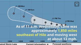
The five-day forecast map for Tropical Storm Lane as of 11 p.m. today.


Tropical Storm Lane formed far out in the East Pacific early Wednesday and is forecast to be a Category 3 hurricane with 120 mph winds about 1,000 miles southeast of Hawaii island when it enters the Central Pacific on Saturday.
Lane had maximum sustained winds of 50 mph as of 11 p.m. and it is expected to strengthen over the next three days as it travels west, said Derek Wroe, lead forecaster with the National Weather Service in Honolulu. The forecast calls for Lane to reach hurricane strength Thursday and start moving west-northwest late this week.
Lane was about 2,010 miles southeast of Hilo and moving west at 12 mph at 11 p.m. Wednesday. Tropical storm-force winds of 39 mph or more extended up to 35 miles from Lane’s center, according to the National Hurricane Center in Miami, which monitors East Pacific storms.
“Warm ocean water is the fuel for hurricanes,” Wroe said. “Expect intensification at least into the weekend. By midday Saturday, it should be approximately 1,000 miles southeast of the Big Island.”
By Monday, Lane is expected to still be a major hurricane a few hundreds of miles southeast of Hilo, with sustained winds of 115 mph and heading northwest, according to the five-day forecast.
National Hurricane Center forecasters said, “Lane seems destined” to become a major hurricane like Hector, which passed safely south of the islands last week.
Don't miss out on what's happening!
Stay in touch with breaking news, as it happens, conveniently in your email inbox. It's FREE!


