Ulika’s remnants bringing muggy, rainy weather

NOAA / NATIONAL WEATHER SERVICE
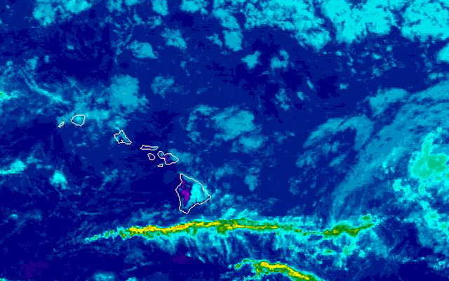
This composite satellite image shows clouds over windward and mauka sections of most islands this morning as remnants of former Tropical Storm Ulika approach the Big island from the east.
Expect humidity to increase as well as the chance of showers as moist, tropical air from the remnants of former Tropical Storm Ulika move over the state.
Most of what’s left of Ulika was about 400 miles southeast of Hawaii island.
But tradewinds are blowing some rain clouds in front of Ulika over windward and mauka areas. An isolated downpour over Honaunau on Hawaii island produced over 3 inches of rain Friday night night.
“During the weekend, moisture will continue to increase over the islands from east to west,” forecasters said. “An increasingly wet trade wind pattern is the likely result, with frequent showers over windward/mauka areas and scattered showers spilling over into many leeward areas.”
Forecasters expect most of the rains this weekend will be light or moderate. Although a few heavy showers are possible.
“Some heavy rain could make it into the islands as early as tomorrow afternoon and overnight, but the greater chance begins Monday,” forecasters said. “Localized heavy downpours appear increasingly likely during this time, and isolated thunderstorms cannot be ruled out. … The heavy rains will likely be somewhat spotty and not occurring all the time,”
Don't miss out on what's happening!
Stay in touch with breaking news, as it happens, conveniently in your email inbox. It's FREE!
Trade winds should gradually return late next week.
The forecast for the state calls for mostly cloudy skies with showers likely in windward and mauka areas and partly cloudy skies and scattered showers in leeward areas. Expect partly to mostly cloudy skies Sunday and mostly cloudy skies Monday through Wednesday, as the bulk of Ulika’s moisture moves over the state.
Breezy tradewinds this weekend will shift to the east and southeast, bringing the chance of afternoon showers in leeward areas early next week.


