Hurricane Madeline heads west toward Hawaii; storm warnings, watches issued
NATIONAL HURRICANE CENTER
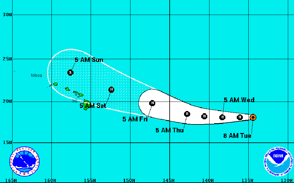
This graphic shows the projected path and intensity of Hurricane Lester.
CENTRAL PACIFIC HURRICANE CENTER
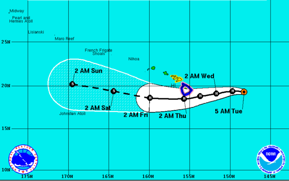
This graphic shows the projected path and intensity of Hurricane Madeline.
NOAA / NASA / GOES WEST
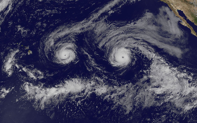
This satellite image taken Monday shows Hurricane Madeline and Hurricane Lester on paths toward Hawaii.

NOAA / GOES WEST
Hurricane Madeline, left, and Hurricane Lester, right, are on paths that could take the storms near Hawaii this week.


• Forecast track for Hurricane Lester Opens in a new tab
Update: 5 a.m. Tuesday
Hurricane Madeline weakened slightly overnight but was still a powerful Category 3 storm and the National Weather Service issued a tropical storm warning for Hawaii island and a tropical storm watch for Maui County this morning. The Big Island is also under a hurricane watch.
At 5 a.m., Madeline was 445 miles east of Hilo, with maximum sustained winds of 120 mph and higher gusts, moving west at 10 mph.
A tropical storm warning means that tropical storm conditions are expected within 36 hours, while a watch means storm conditions are possible within 48 hours. A flash flood watch has also been issued for the Big Island.
According to the Central Pacific Hurricane Center, tropical storm conditions are expected over Hawaii island Wednesday while hurricane conditions are possible. Tropical storm conditions are also possible over Maui County on Wednesday. “Heavy rains associated with Madeline may reach Hawaii County on Wednesday, and may impact other Hawaiian islands later Wednesday into Friday. Madeline is expected to produce total rain accumulations of 5 to 10 inches, with isolated maximum amounts near 15 inches, across the Big Island, especially over windward portions. This rainfall may lead to dangerous flash floods and mudslides. Madeline may produce up to 4 inches of rainfall across Maui County,” forecasters said.
Don't miss out on what's happening!
Stay in touch with breaking news, as it happens, conveniently in your email inbox. It's FREE!
Dangerous surf is also expected as the storm approaches. A high surf warning is in effect for eastern shores of Maui through 6 a.m. Thursday, while an advisory has been issued for eastern shores of the other islands.
Farther east in Pacific, Hurricane Lester was weakening but remained a powerful Category 3 storm, with maximum sustained winds of 120 mph. Lester was about 1,355 miles east of Hilo, moving west at 14 mph at 5 a.m.
Gradual weakening is forecast during the next 48 hours and its forecast track has it moving just north of the Big Island Saturday.
Hurricane-force winds extend outward up to 35 miles from the center and tropical storm-force winds extend outward up to 90 miles, according to the National Hurricane Center.
Previous coverage
The National Weather Service posted a hurricane watch for Hawaii island as Madeline strengthened into a major category 4 storm that could come “dangerously close” to the Big Island Wednesday.
Madeline had maximum sustained winds of 130 mph and was centered 490 miles east of Hilo and 680 miles east of Honolulu moving west at 9 mph at 2 a.m. Hurricane-force winds extend 30 miles from the center and tropical storm-force winds go out 125 miles from the center.
A hurricane watch means hurricane conditions are possible on Hawaii island in the next 48 hours.
“Impacts from Madeline are becoming increasingly likely over portions of the state, including the possibility of damaging winds and flooding,” forecasters said. “It is important for those in the State of Hawaii to not focus too closely on the exact forecast track of Madeline. With an average forecast track error of about 85 to 150 miles in the 48 to 72 hour time range, it is still too soon to say with certainty which islands could be directly impacted. It is also important to note that significant impacts can extend well away from the center of a tropical cyclone.”
A high surf warning has been issued for the east-facing shores of Maui from 6 a.m. Tuesday to 6 a.m. Thursday.
The east shores of Kauai, Oahu, Molokai, and west Maui are under a high surf advisory.
Surf is expected to build to 10 to 15 feet on Tuesday afternoon and rising to 10 to 20 feet late Tuesday night and Wednesday, according to the National Weather Service.
A flash flood watch is also posted for Hawaii island Wednesday and Thursday because of the threat of flooding rainfall.
On its current track, Madeline is expected to pass south or over Hawaii island on Wednesday at hurricane strength.
Madeline is likely to bring strong waves, winds and rains to Hawaii island and Maui through Thursday.
Forecasters expect humidity to increase and an increase in showers starting Tuesday as tropical moisture ahead of Madeline reaches the state.
Surf on east shores is also expected to rise and could build to 8 to 12 feet on Tuesday and 15 to 25 feet on Wednesday on Hawaii island.
The weather service estimates Hilo has a 7 percent chance of seeing hurricane-force winds and a 63 percent chance of tropical storm-force winds. South Point has a 16 percent chance of hurricane-force winds and Kona has a 5 percent chance.
The chance of tropical storm-force winds at South Point is 73 percent and Kailua Kona’s chance of getting tropical storm-force winds is 56 percent.
The storm’s impact on other islands is still uncertain.
“We’re still going to get an increase in wind speeds. If it takes the northerly track you’ll get an increased chance of wind, surf and an increased chance of rain and flooding for Oahu,” said Chevy Chevalier, a meteorologist with the Honolulu office of the National Weather Service.
Effects on Oahu and Kauai will be less if the storm takes a southerly route.
Air Force reserve hurricane hunter planes are heading to Hawaii and will fly through the storm Tuesday, which should give forecasters better information to track and predict the storm, Chevalier said.
The storm could also coincide with the scheduled visit of President Obama to Oahu Wednesday night and the start of the World Conservation Congress Thursday.
Behind Madeline, Hurricane Lester weakened slightly to powerful category 3 storm with winds of 125 mph, about 1,435 miles east of Hilo in the East Pacific tonight. Lester continued to move west at 14 mph and should cross into the Central Pacific Wednesday.
Hurricane-force winds extend 35 mph from the center and tropical storm-force winds extend 90 miles from the center.
Forecasters said Lester is still too far away to predict what effects it will have on Hawaii. If it takes a northerly track, it may just bring surf and not much in the way of winds or rains. But the potential is there for Lester to pass over or near Hawaii.
Forecasters said people should be prepared for a hurricane, if they haven’t already done so, with seven days of emergency supplies and a plan of what to do and how to keep in touch with relatives in the event of a storm.
“If you’re not prepared, you should be, especially if you live on the Big Island or Maui,” Chevalier said. “Don’t let your guard down.”
25 responses to “Hurricane Madeline heads west toward Hawaii; storm warnings, watches issued”
Leave a Reply
You must be logged in to post a comment.


I’m most worried about the humidity and accompanying heat index. I live in a place without air conditioning and it’s just brutal when it’s humid and still.
If I had to choose between hot and humid or 80mph winds . . . Well a little sweat never hurt anybody!
so I won’t hug you until the storm passes!
For most people I’d say no, but for you I’d make an exception. You can hug me anytime. Every time you hug me I get that warm and fuzzy feeling inside.
I understand your perspective, sometimes we head to the matinee movie to avoid the heat, it used to be called a “bargain matinee”, but not such a bargain anymore and you have to smuggle in food and drink to stay on budget. Public libraries are another cool hang out but you gotta be quiet.
What did the Hurricane say to the Coconut tree’s?___________Hold on to your nut’s here comes a blow job!
wow. haven’t heard that one since 8th grade back in the early 80s
Thanks, I needed that, the laugh I mean.
Sheesh how did you not get censored for the bj joke? I’ve been censored for using the word dam spelled correctly. I used it for example as in dam politicians not worth a dam and don’t do anything worth a dam unless it benefits them in some way. Reviewed for moderation every time.
Too busy laughing.
Well dam.
hey..very sexist!
How so? you don’t know the hurricane or tree’s genders
I like the “… this is no ordinary blow job” version better
in da bar we say eh ge ya iburo hana jyo
Too funny! Mahalo!
Madeline is gonna be close or upon us shortly. More rain for my weeds. Everybody prepared?
Don’t PANIC everyone! If these Hurricanes are anything like June Jone’s in Kapolei; purely over hyped!
Shop now – just in case.
“Just in case” meaning case lots only. 144 rolls of toilet paper.
Will this storm rain on Obama’s parade?
Those 2 big mountains will do their job and obliterate any hurricane. Just look at the satellite and infra red images for the last 2 that followed that track. Rain and wind and albizia trees in Puna to worry about.. for the big island.
Let us pray for all on the Big Island.
Checked my generator in case there is power outage so I can keep my frig running so my food won’t spoil and I can run my microwave and coffee maker…..