Tropical Storm Madeline moves toward isles as Lester becomes hurricane
NATIONAL HURRICANE CENTER
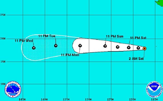
Hurricane Lester was located about 595 miles southwest of the southern tip of Baja California, moving west at 12 mph.
NATIONAL HURRICANE CENTER
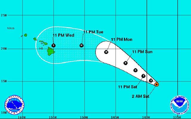
Tropical Storm Madeline was located about 1,160 miles east-southeast of Hilo, moving west-northwest at 10 mph.
NATIONAL HURRICANE CENTER
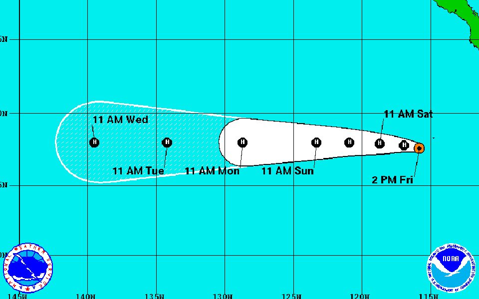
This graphic shows the projected 5-day path and intensity of Tropical Storm Lester.
NOAA/ GOES WEST
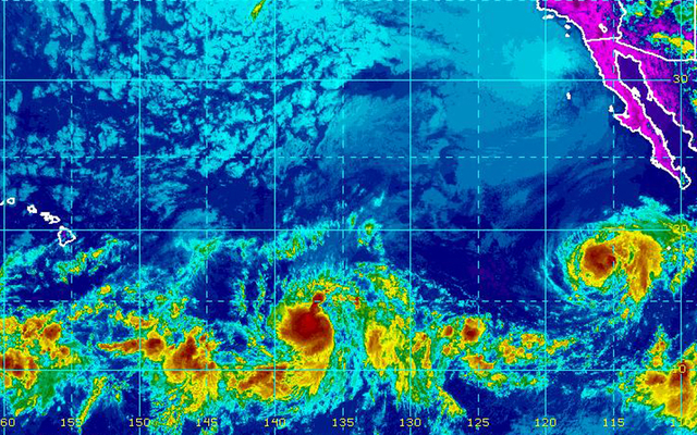
This satellite image taken late this morning shows Tropical Depression 14E (lower center) and Tropical Storm Lester (right near Mexico). Another area of clouds south of Hawaii is not expected to affect the weather in the state.
NATIONAL HURRICANE CENTER
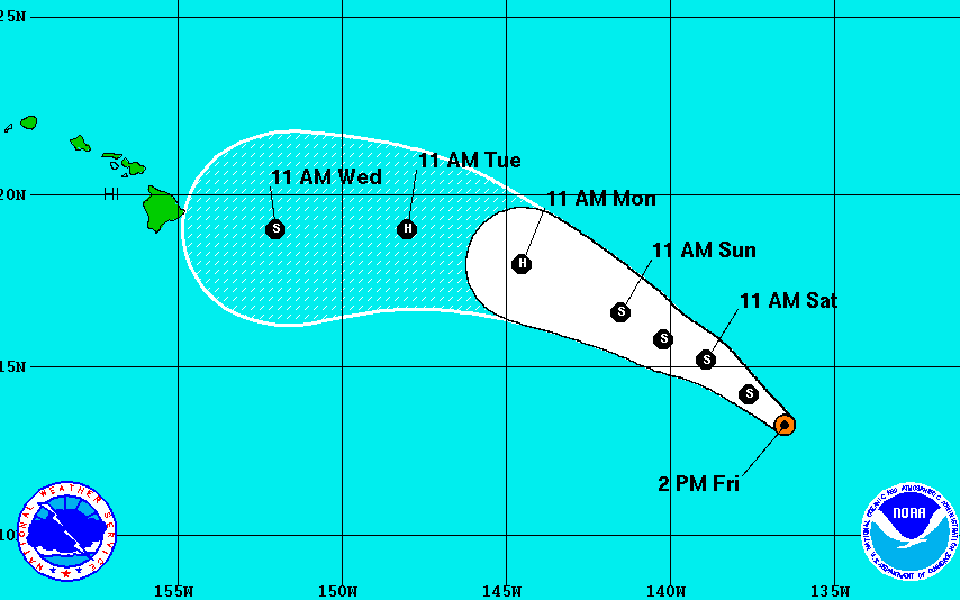
This graphic shows the five day projected track and intensity of Tropical Depression 14E.


Update 11 p.m.
Tropical Storm Madeline continues to strengthen as it moves west-northwestward tonight.
The National Hurricane Center reported it was located about 1,160 miles east-southeast of Hilo, moving west-northwest at 10 mph.
In the next couple of days, forecasters expect Madeline to continue northwestward with a decrease in forward speed and could become a hurricane on Sunday night or Monday.
Maximum sustained winds have increased to nearly 50 mph with higher gusts, and tropical storm-force winds extend outward up to 60 miles from the center.
Hurricane Lester is turning toward the west while it strengthens tonight, with maximum sustained winds of 85 mph.
Don't miss out on what's happening!
Stay in touch with breaking news, as it happens, conveniently in your email inbox. It's FREE!
It was located about 595 miles southwest of the southern tip of Baja California, moving west at 12 mph.
Forecasters expect Lester to continue moving west with an increase in forward speed and to strengthen during the next couple of days.
Hurricane-force winds extend outward up to 25 miles from the center, and tropical storm-force winds extend outward up to 90 miles.
Update 5 p.m.
Tropical Storm Madeline formed east-southeast of Hawaii today, moving west-northwest at about 12 mph.
The National Hurricane Center reported Madeline was about 1,235 miles east-southeast of Hilo with sustained winds of 40 mph.
It is expected to continue moving west-northwestward over the weekend, and could become a hurricane on Monday.
Lester developed an eye and became a hurricane about 550 miles southwest of the southern tip of Baja California, moving west at 9 mph.
Forecasters expect Lester to continue west over the next few days with maximum sustained winds of 75 mph.
Hurricane-force winds extend outward up to 25 miles from the center and tropical storm-force winds extend outward up to 90 miles.
Previous coverage
A newly formed tropical depression is likely to strengthen into a hurricane and could pass over or near Hawaii as a tropical storm next week.
Tropical Storm Lester is behind it and is likely to become a hurricane tonight or Saturday, but it is still too far away to say if it will have any impact on Hawaii’s weather.
Tropical Depression 14E is moving west-northwest at 12 mph, about 1,305 miles east-southeast of Hilo at 11 a.m.
It has sustained winds of 35 mph. The storm is moving over an area of warm water with little wind shear, so it is expected to strengthen into a hurricane over the next three days before weakening as it approaches the Big Island.
If it reaches tropical storm strength in the East Pacific, it will be named Madeline. If it crosses into the Central Pacific it will be called Ulika.
Forecasters caution the margin of error in computer models for storms more than 5 days away is 170 miles in either direction. So the storm could still pass well south or north of the islands without much effect on Hawaii’s weather.
If it continues on its current track, it will bring another round of high humidity starting as early as Wednesday and could bring heavy rain and winds through the Labor Day weekend, potentially affecting events at the World Conservation Congress.
Bob Burke, a meteorologist with the National Weather Service, said people should be aware of the approaching storm and monitor weather forecasts but its too early to predict its impact on Hawaii. People should also have storm supplies and an emergency plan in place, whether or not the storm hits Hawaii.
“Be prepared,” Burke said.
At 11 a.m., Tropical Storm Lester was 530 miles southwest of Baja California with sustained winds of 70 mph. It is expected to reach hurricane strength tonight and could send surf to east shores of Hawaii next week, depending on the strength of the winds and its eventual path.
Lester was moving west-northwest at 9 mph.
7 responses to “Tropical Storm Madeline moves toward isles as Lester becomes hurricane”
Leave a Reply
You must be logged in to post a comment.


oh great now cholo has to buy another mega pack of toilet paper
But the forecaster said “It is too early to determine what, if any, impacts this cyclone could have on the Hawaiian Islands near the end of the forecast period.” You need to do what we do and buy a couple of mega packs of TP in June and use those all year round! Of course if a hurricane blows through we will have a roadside stand set up in case anyone needs this (potentially) valuable commodity . . .
Wasn’t that once “KAY”?
Oh Goodie Maybe Obama Will benefit from the rain.
Great watching all the fools buying a ton of toilet paper and five or six cases of water and then they bring it all back the following week. Why don’t they just keep it for the next threat?
The weather forecast is serious. Best if Obama cancel his Hawaii trip.
At least one storm a month now days. My grass drowning. It’s now hot, humid and rain. Not in any particular order.