Flash flood watch, high surf advisory issued as Howard’s remnants move through isles

NATIONAL HURRICANE CENTER
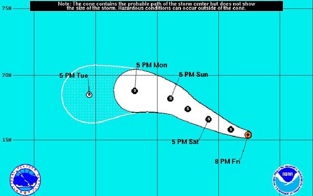
This graphic shows the projected path and intensity of Tropical Storm Ivette.

NOAA / GOES WEST
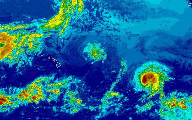
This satellite image taken this afternoon shows a few clouds moving over the islands as remnants of former Tropical Cyclone Howard, center, approach Hawaii and Tropical Storm Ivette, right, marches west toward Hawaii.


UPDATE 5 p.m.
Forecasters today issued a high surf advisory and a flash flood watch as remnants of former Tropical Cyclone Howard move through the islands this weekend.
“The National Weather Service is forecasting rain and possibly thunderstorms to hit Oahu this Sunday into Monday,” Mayor Kirk Caldwell said in a press release today. “We do not expect the same level of rainfall as we did with Tropical Storm Darby, but with the ground still saturated from that event, heavy rains could still lead to flooding, road closures, and possible utility outages.”
The National Weather Service issued a flash flood watch for all islands from Sunday morning through Monday afternoon as some storms could produce heavy rain and thunderstorms.
On Oahu there’s a 90 percent chance of precipitation on Sunday with possible rainfall amounts of 1 to 2 inches.
A high surf advisory is in effect from noon on Saturday through 6 a.m. Sunday, forecasters reported today.
Don't miss out on what's happening!
Stay in touch with breaking news, as it happens, conveniently in your email inbox. It's FREE!
A surface low associated with Howard will build Saturday, producing advisory-level surf across the Big Island and Maui County by morning and on Oahu and Kauai by the afternoon.
Swells of 6 to 9 feet are expected to build along east-facing shores on Saturday afternoon and peak Saturday night.
As Howard’s remnants pass over the islands on Sunday, elevated surf may persist along east shores of Oahu and Kauai.
The Department of Environmental Services and Department of Design and Construction will be monitoring sewer flows throughout the storm, while Oahu Transit Services is prepared to move Handi-vans and buses from their overnight storage lot in the event of heavy rains.
PREVIOUS COVERAGE:
The breezy tradewind weather expected today is likely to change over the weekend as remnants of former Tropical Storm Howard move over the state, bringing potentially heavy rain and even thunderstorms through Monday.
And another system, Tropical Storm Ivette, is not far behind.
Saturday should start much like today, with the usual windward and mauka showers and tradewinds blowing some of the showers over to leeward areas.
Humidity from Howard’s remnants will increase and there’s a 90 percent chance of rain Saturday night and Sunday in Honolulu and south shores of Oahu.
Forecasters said clouds and showers ahead of Howard could start arriving Saturday afternoon. Saturday night’s forecast calls for more showers and locally heavy rainfall is possible.
Sunday should see cloudy skies with occasional showers. Some of the rain may be heavy and thunderstorms are possible.
Winds will also turn southerly, bringing muggy conditions.
The muggy, rainy weather is expected to continue into at least Monday night and tradewinds should begin to return Tuesday.
But a weakened Tropical Storm Ivette could bring more muggy conditions and rain as early as Wednesday.
Forecasters said Howard was about 700 miles east-northeast of Hilo this morning and Ivette was about 1,600 miles east-southeast of Hilo and 1,515 miles west-southwest of Baja, California.
Ivette’s winds increased to 60 mph as the storm moved west at 13 mph late this morning.
Ivette could still strengthen slightly, but is no longer expected to become a hurricane.
The storm should weaken to a post-tropical cyclone as it nears Hawaii.
Swells from Howard and Ivette are expected to send surf that could reach advisory levels of 8 feet through the beginning of next week.
Meanwhile, National Hurricane Center forecasters are also watching an area of disturbed weather southeast of Ivette that could develop into a tropical cyclone in the next five days.
4 responses to “Flash flood watch, high surf advisory issued as Howard’s remnants move through isles”
Leave a Reply
You must be logged in to post a comment.


No wonder I see all those govt workers out clearing the streams and drainage along the sides of the roads. NOT!
Oahu sure is green
You can thank the blessing of global warming for that!
My grass drowning.