Olivia weakens to a tropical depression as heavy rain continues for isles
CINDY ELLEN RUSSELL / CRUSSELL@STARADVERTISER
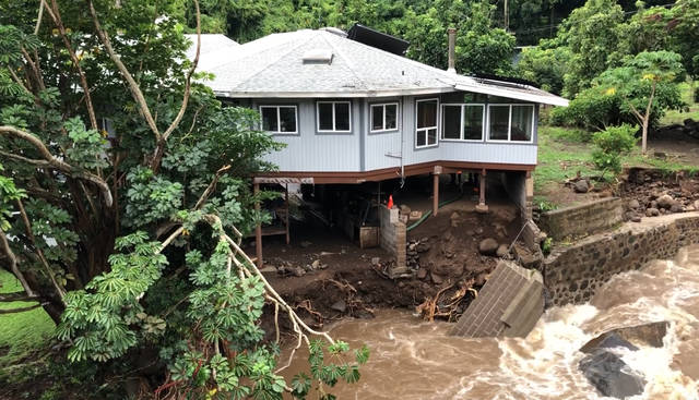
This screen grab from a video shows a house today near the Waihee River Bridge in West Maui.
DENNIS ODA / DODA@STARADVERTISER.COM
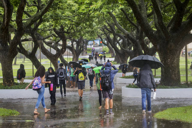
Rain was heavy at times at the University of Hawaii earlier today due to Tropical Storm Olivia. The wet conditions caused a sea of umbrellas to open as students walked to and from classes.
CINDY ELLEN RUSSELL / CRUSSELL@STARADVERTISER.COM
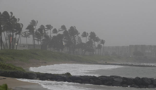
Kahului Harbor was socked in with rain from Tropical Storm Olivia early this morning.
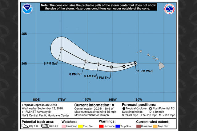
CENTRAL PACIFIC HURRICANE CENTER
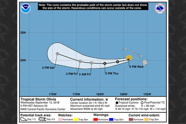
The forecast track for Tropical Storm Olivia as of 11 p.m. Wednesday.


UPDATE: 12:10 a.m.
The National Weather Service in Honolulu has issued a flash flood warning for the island of Oahu in Honolulu County until 3:00 a.m. hst.
At 12:10 a.m. hst, radar indicated extremely heavy rain moving over Oahu from the southeast, impacting the area from Kailua to Kalama Valley to Niu Valley with rainfall rates greater than 2 inches per hour. This heavy rainfall will spread to other areas of Oahu soaked earlier in the night, mainly southern, central and windward Oahu. Stream levels will again rise rapidly as this new burst of heavy rain moves over the area.
This warning includes the entire island of Oahu, except the Waianae mountains, and the Waianae coast.
11:46 p.m.
The flash flood warning remains in effect until 12:30 am hst for the island of Oahu in Honolulu County.
Don't miss out on what's happening!
Stay in touch with breaking news, as it happens, conveniently in your email inbox. It's FREE!
At 11:45 p.m. hst, radar indicated that heavy rain had eased over southeast and central Oahu, but runoff remains high and stream levels are elevated.
Locations in the warning include but are not limited to… Honolulu, Waimanalo, Mililani, Wahiawa, Schofield Barracks, Kaneohe Marine Base, Hawaii Kai, Palolo, Kahaluu, Ahuimanu, Salt Lake and Kailua.
11 p.m.
Olivia is now a tropical depression, heading west-southwest at 18 mph.
As of 11 p.m., Olivia was 195 miles west-southwest of Honolulu and 160 miles south-southwest of Lihue.
Olivia is forecast to turn toward the west-northwest on Friday.
Maximum sustained winds are near 35 mph with higher gusts, and little change in strength is forecast through Thursday night.
The Honolulu Department of Parks and Recreation plans to close Hanauma Bay on Thursday due to anticipated high surf and strong currents. There’s also an islandwide brown water advisory issued by the state Department of Health. The visitor’s center will remain open.
A high surf warning for the Oahu’s eastern shores, with waves as high as 16 feet, remains in effect until 6 a.m. Thursday.
10 p.m.
A flash flood warning has been issued for Oahu until 12:30 a.m. Thursday.
Extremely heavy rain is moving over most of the southern half of the island, forecasters said. Rain is especially heavy over southeast parts from Hawaii Kai to Honolulu to Pearl City to Mililani. Rainfall rates of three to four inches per hour are expected to lead to flash flooding.
The National Weather Service said deep tropical moisture and instability are interacting with the mountains on Molokai and Lanai to produce rain showers drifting into Oahu tonight.
Locations in the warning include but are not limited to Honolulu, Waimanalo, Maunawili, Manoa, Mililani, Wahiawa, Hawaii Kai, Aina Haina, Niu Valley, Palolo, Salt Lake and Kailua.
Flood advisories have also been issued for the Big Island and Maui until 12:30 a.m. Thursday.
On Hawaii island, rain continues to fall over the Kohala and Hamakua districts, with rates between one and two inches per hour. Areas affected are Kamuela, Waikoloa Village, Waipio, Pololu and Waimanu Valleys, and Saddle Road Junction.
On Maui, heavy rain is reported to be along the southeast slopes of Haleakala, with rain falling at a rate near two inches per hour. Kaupo, Kipahulu, Nahiku, Hana and Keokea are under the advisory.
8 p.m.
All public schools and Hawaii State Department of Education offices will be open Thursday except for Kilohana Elementary. All afterschool activities will resume statewide.
“We will continue to work with county and state partners to monitor the weather through the night for Maui County and Kauai. If there are any updates for these areas, we will let the public know right away,” said Superintendent Dr. Christina Kishimoto. “Our schools were able to get through the storm largely in great shape; however, certain areas have family homes that were highly impacted.”
Tropical Storm Olivia, south of Kauai tonight, will continue to track west away from the islands. Wet weather is expected for all islands at least through early Friday.
The flood warnings for Maui and Molokai have expired, but flood advisories are in effect for Oahu, Hawaii island and Lanai.
The flood advisory for Oahu is in effect until 10:45 p.m., as heavy rain falls over the southern portions of the island, from Manoa to Fort Shafter to Kunia.
The Honolulu Fire Department responded to a number of Olivia-related emergencies today, including blown roofs, downed trees and downed power lines.
Locations in the advisory include but are not limited to Honolulu, Salt Lake, Pearl City, Aiea, Halawa, Waipahu, Waimalu, Kapolei and Waikele.
The flood advisory for the Big Island is in effect until 9:30 p.m.
Forecasters said there’s moderate to heavy rainfall over the Kohala, Hamakua and North Kona districts, with rates between one and two inches per hour.
Locations in the advisory include but are not limited to Kamuela, Waikoloa Village, Waipio, Pololu and Waimanu Valleys, Puuanahulu, and Saddle Road Junction.
The flood advisory for Lanai is in effect until 10:30 p.m. as heavy rain falls over the northern half of the island.
5:30 p.m.
Oahu remains under a wind advisory until 6 a.m. Thursday.
Weather officials said to expect winds coming from the east at 20 to 35 mph, with localized gusts over 50 mph.
Winds this strong can knock down tree branches, cause car doors to slam, and result in sporadic power outages.
5 p.m.
The tropical storm warning for Oahu and Maui County has been discontinued.
As of 5 p.m., Olivia was 110 miles southwest of Honolulu and 145 miles west-southwest of Kaunakakai, heading west-southwest at 20 mph. Olivia is expected to continue moving in this direction through Thursday, followed by a turn to the west on Friday.
Weakening is forecast during the next 48 hours, forecasters said, and Olivia is expected to become a tropical depression tonight or early Thursday.
Maximum sustained winds are near 40 mph with higher gusts, and tropical-storm-force winds extend out 70 miles from the center.
A flash flood warning has been extended for Maui until 7:15 p.m. and Molokai until 6:15 p.m. tonight.
On Maui, rainfall has eased across the island but runoff levels remain high. Maui County Emergency Management reported that the Lower Honoapiilani Road has been closed and several homes in the area were evacuated due to flooding. Honolua Gulch also overflowed onto Honoapiilani Highway. Ulaino Road and Waikoloa Road remain closed near Hana.
On Molokai, rainfall has also eased but water levels in Kaunakakai Gulch and Kawela Gulch remain high. Emergency officials earlier reported numerous low-water crossings along Highway 450 were flooded.
On Oahu, a high surf warning for eastern shores, with waves as high as 16 feet, is in effect until 6 a.m. Thursday.
3:50 p.m.
Koko Head Shooting Complex is closed for safety reasons because of the strong winds and heavy rain, the Honolulu Department of Parks and Recreation said.
Officials will determine when to reopen the complex, depending on the weather.
3:33 p.m.
A flash flood watch for the entire state has been extended to 6 a.m. Friday.
“Moisture from Tropical Storm Olivia is forecast to continue producing heavy rainfall,” the National Weather Service said. “The heaviest rain is over Molokai this evening.
Tonight, the heaviest rain is expected to shift west over Oahu and Kauai and continue through Thursday as moisture from Olivia moves west, the weather service said.
Four to six inches of rain with isolated amounts of up to eight inches are possible for Oahu and Kauai.
3:18 p.m.
The National Weather Service has extended a flash flood advisory for Oahu to 6:15 p.m.
On Oahu, moderate to heavy showers were falling over the southeast half of the island at about 3:10 p.m., and rain was falling at a rate of one to two inches per hour, the weather service said.
Rain is expected to continue into this evening.
The advisory includes, but is not limited to Honolulu, Hauula, Waimanalo, Mililani, Haleiwa, Wahiawa, Schofield Barracks, Hawaii Kai, Laie, Palolo, Ahuimanu, and Punaluu.
Meanwhile, a flood advisory is in effect for Hawaii island until 5 p.m.
Moderate to heavy rain was falling along the slopes of the South Kohala and North Kona districts at about 2 p.m., the weather service said.
The heaviest rain was falling at about one inch per hour along Mamalahoa Highway between Waikoloa Road junction and Kalaoa.
3:07 p.m.
A flash flood warning for Molokai has been extended to 6:15 p.m., the National Weather Service said.
At 3 p.m., rainfall was easing across the island, but water levels remained high for Kaunakakai Gulch and Kawela Gulch.
A flash flood warning means flooding is imminent or occurring in low-lying areas.
2:46 p.m.
Several homes along lower Honoapiilani Highway are being evacuated because of rising water in a nearby river, Maui County says.
Motorists should avoid the highway in the 4700 to 4800 block.
In addition, firefighters have rescued four people from one home in Waihee Valley.
Honoapiilani Highway is under water near mile marker 32.41 in the area of Honolua Bridge, according to the state Department of Transportation. DOT said the water level is coming down, but reminded motorists not to cross floodwaters.
2:40 p.m.
Maui Electric Co. said that as of 2 p.m. its crews were working on restoring power to a total of about 7,900 customers in parts of Upcountry and East Maui, and on Molokai. The total includes about 6,800 customers in the Upcountry and East Maui areas and about 1,100 customers in Kalaupapa and East and West Molokai.
2:30 p.m.
The softball fields at Patsy T. Mink Central Oahu Regional Park are closed because of ground saturation from the rain, the Honolulu Department of Parks and Recreation says in a tweet. The city is notifying permit-holders.
2:23 p.m.
The National Weather Service has issued a flood advisory for the west side of Hawaii island until 5 p.m.
“At 1:58 p.m., radar showed that moderate to heavy rain has developed along the slopes of the South Kohala and North Kona Districts,” the advisory said. “The highest rain rates were about one inch per hour along the Mamalahoa Highway between the Waikoloa Road junction and Kalaoa.”
The advisory includes Kailua-Kona, Puuanahulu, Kamuela, Kainaliu, Waikoloa Village, Honalo, Kalaoa, Holualoa, Puako, Kealakekua, and the Mamalahoa Highway between mile markers 10 and 32, according to forecasters.
2:15 p.m.
Lanikuhana Avenue in Mililani is blocked between Kamehameha Highway and Anania Drive because of a hanging tree branch, police say.
Drivers can use Meheula Parkway to get around the blockage.
2:10 p.m.
A weakening Olivia was barely hanging onto its tropical storm status this afternoon as it moved south of Oahu.
The Central Pacific Hurricane Center said that at 2 p.m., the storm had 40 mph sustained winds, centered 45 miles south of Honolulu and 70 miles west of Kaunakakai. Tropical-storm-force winds extend out 90 miles from the center.
The storm was moving west at 20 mph and forecasters said that a turn toward the west-southwest will occur this evening and continue through Friday.
Gradual weakening is forecast during the next 48 hours. If the sustained winds fall below 39 mph, Olivia will be reclassified as a tropical depression.
2:01 p.m.
Kamehameha Highway on Oahu’s North Shore is closed near Sunset Beach Elementary School because of a fallen ironwood tree, police say.
The tree is blocking the entire roadway.
1:53 p.m.
City & County of Honolulu officials said that Wahiawa Botanical Garden has been closed due to high winds, and Central Oahu Regional Park is also closed.
1:45 p.m.
Heavy rainfall and flooding has made parts of Highway 450 on Molokai impassable, the National Weather Service says.
At about 1:30 p.m., water in Kaunakakai Gulch was backing up due to debris in the channel, and radar showed showers falling at a rate of about one inch per hour over parts of the island.
Molokai remains under a flash flood warning until 3:15 p.m.
1:30 p.m.
The flash flood warning for Maui has been extended to 4:15 p.m.
The National Weather Service in Honolulu said, “At 1:11 p.m., radar showed heavy rain continuing over portions of Maui. The highest rates were estimated to be 2 to 3 inches per hour over the West Maui Mountains and 1 to 2 inches per hour over the southeastern slope of Haleakala. Waikoloa Road and Ulaino Road remain closed near Hana. Low water crossings along Piilani Highway from Waiopae to Kipahulu are at risk of being closed by flooding.”
Oahu remains under a flood advisory until 3:15 p.m.
1:20 p.m.
President Donald Trump has signed the federal disaster declaration that Gov. David Ige had requested Tuesday as Tropical Storm Olivia threatened the islands.
At an afternoon news conference, Ige said that Vice President Mike Pence had informed him in a phone call that the president had approved the request today.
The governor said the declaration allows broader support from the Federal Emergency Management Agency.
Ige also said he has activated about 300 Hawaii National Guard troops who have been stationed on Hawaii island, Maui and Oahu, and will be ready to go to any area that needs assistance.
At the news conference, Maui Mayor Alan Arakawa, via telephone, said that despite some flooding, heavy rains and downed trees, the county so far has “not really seeing large areas of damage.” But he stressed that the islands are still feeling the effects of Tropical Storm Olivia.
12:38 p.m.
The right-hand Kaneohe-bound lane of the Likelike Highway has reopened about a half-mile before the tunnels after a fallen tree was cleared, city officials said.
12:25 p.m.
The National Weather Service in Honolulu has issued a flood advisory for Oahu until 3:15 p.m.
“At 12:10 p.m., radar showed moderate to heavy rainfall over the southeastern half of Oahu. Rain rates of 1 to 2 inches per hour were observed by gauges and radar. Rainfall is expected to continue through the afternoon,” the advisory says. “Locations in the advisory include but are not limited to Honolulu, Hauula, Waimanalo, Mililani, Haleiwa, Wahiawa, Schofield Barracks, Kaneohe Marine Base, Hawaii Kai, Laie, Palolo and Kahaluu.”
12:10 p.m.
The flash flood warning for Molokai has been extended until 3:15 p.m. today.
At 11:54 a.m., radar showed that heavy rain has moved over most of Molokai as the center of Tropical Storm Olivia passes to the south of the island, the National Weather Service said in a bulletin. The gauge in Halawa Stream showed a recent increase in water level of 3 feet.
Police on Molokai reported that water was flowing across Highway 450 near Kawela.
Noon
A Kaneohe-bound lane of the Likelike Highway has been closed about a half-mile before the tunnels. A fallen tree is blocking the right lane, city officials said.
11:40 a.m.
City officials have closed the Pali Lookout due to fallen trees and high winds caused by Tropical Storm Olivia.
The Pali Lookout Road, as well as Diamond Head Road near Makalei Place, are closed in both directions due to fallen trees.
Rainy conditions also may have contributed to a power outage in the McCully area where about 1,140 customers were affected. Hawaiian Electric Co. spokesman Peter Rosegg said a troubleshooter is en route to McCully.
11:15 a.m.
WAILUKU >> Maui County officials expect the brunt of the storm’s impact will be felt around 11:30 a.m., according to Keith Regan, county managing director.
Overnight and through this morning, the worst effects from Olivia reported by the county were a flooded road in Iao Valley caused by a blocked storm drain, landslides in the same area and some landslides in Hana. There also were a couple relatively minor power outages, including one in Haiku that affected about 500 customers and was fixed overnight.
Regan said those problems were addressed well. “So far, it’s been manageable,” he said.
Tommy Duarte, a 79-year old Iao Valley resident who has lived in the area for 70 years, said rain and wind overnight didn’t have a major effect on the big stream that runs below his home.
“It didn’t do much,” he said. “It was no biggie.” But Duarte also was aware that the island was not out of danger from Olivia yet. “It’s not finished,” he said of the storm.
11 a.m.
Tropical Storm Olivia, which made a historic landfall on the island of Maui this morning followed by another landfall on Lanai, was about 40 miles west of Kahului and 60 miles east of Honolulu late this morning.
At 11 a.m., the Central Pacific Hurricane Center said the storm had maximum sustained winds of 45 mph and was heading west at 15 mph. Tropical storm-force winds of more than 39 mph extend out 90 miles from the center. It was centered just west of Lanai late this morning. “A turn toward the west-southwest will occur today, with a similar west-southwest motion expected through Friday. … Gradual weakening is forecast during the next 48 hours,” forecasters said.
Olivia made landfall at 9:10 a.m. along the windward coast of the West Maui Mountains, about 10 miles northwest of Kahului, and a second landfall occurred on the northwest coast of Lanai at 9:54 a.m., about 6 miles north-northeast of Lanai City.
Hurricane center forecasters expected Olivia to continue westward and pass south of Oahu early this afternoon.
The island of Maui is under a flash flood warning until 1:30 p.m. The islands of Maui County and Oahu remain under a tropical storm warning, which was lifted earlier for the Big Island and Kauai. The entire state remains under a flash flood watch through Thursday night.
Forecasters said that strong wind shear and Olivia interaction with the high terrain of Molokai and Maui should weaken the system. Also, a “turn toward the west-southwest is expected as the weaker system becomes increasingly steered by the low-level trade wind flow,” forecasters said. “Olivia is forecast to become a tropical depression by Thursday and a post-tropical remnant low on Friday. This could occur sooner if Olivia is significantly weakened by island terrain.”
10:50 a.m.
The Coast Guard has reopened commercial ports at Hawaii Island and Kauai County this morning since there is no threat of impact from Tropical Storm Olivia.
Ports at Oahu and Maui County remain closed at this time. Coast Guard Petty Officer 3rd Class Amanda Levasseur said they haven’t seen any effects to the ports so far.
The Coast Guard will conduct an assessment once the storm passes.
UPDATE: 10:05 a.m.
The National Weather Service has posted a flash flood warning for Maui until 1 p.m. as the center of Tropical Storm Olivia made landfall on the island, something that has not happened in modern history.
The center of Olivia made landfall at 9:10 a.m. near Kahakuloa on the windward side of the island, about 10 miles northwest of Kahului, according to the weather service.
Asked if there is a precedent for Maui being hit directly by a tropical storm, National Weather Service forecaster Matt Foster said, “as far as the era of having historical records on hand, no. But probably in the historical past, it probably has happened.”
The flash flood warning for the island said that at 9:54 a.m., radar showed heavy rainfall over the southeastern slope of Haleakala from Ulupalakua to Hana, according to the National Weather Service. Rain rates were estimated to be about 1 to 2 inches an hour. Low water crossings along Piilani Highway will become impassable, especially from Waiopae to Kipahulu and including Pahihi Gulch and Kalepa Gulch, forecasters said. Locations in the warning include, but are not limited to, Keokea, Makena, Pukalani, Kihei, Kaupo, Keanae, Makawao, and Piilani Highway from Ulupalakua to Hana. Forecasters say the rainfall is expected to continue to wallop the island for several hours.
Crews of the Hawaii Department of Transportation meanwhile have cleared two fallen trees on Hana Highway at mile-markers 21 and 26. Motorists are urged to avoid the highway as debris may continue to fall due to windy and rainy conditions.
The public is also urged to steer clear from streams, drainage ditches and low-lying areas.
On Oahu, 16 people have sought shelter at five shelters on Oahu as of Tuesday night, according to John Cummings, spokesman of the city Department of Emergency Management.
Six people are at Manoa Valley District Park, three at Kaneohe District Park, three at Kalihi Valley District Park, two at Waianae District Park, one at Kailua District Park and one at Brigham Young University.
The American Red Cross-Hawaii Chapter has set up eight shelters on Oahu, seven in Maui County and one in Hawaii County.
9:12 a.m.
The flash flood warning for Molokai has been extended until 12:15 p.m. today.
At 8:56 a.m., radar showed rainfall continuing along the upper slopes of central and east Molokai, according to the National Weather Service. Water levels in Kawela Gulch and Kaunakakai Gulch also remain high. Low water crossings along Highway 450 from Kaunakakai to Pukoo likely have flowing water.
Rainfall will continue to move over Molokai as the center of Olivia approaches from the east.
9 a.m.
Hana Highway near mile-marker 21 is blocked in both directions due to a fallen tree, according to the Hawaii Department of Transportation. Motorists are urged to avoid the area.
Crews have since cleared debris on the highway at mile-marker 14.
8:15 a.m.
Now just off the northern coast of Maui, Tropical Storm Olivia has shown no signs of weakening this morning.
Located about 25 miles east-northeast of Kahului and 115 miles east of Honolulu, Olivia was clocked with maximum sustained winds of 45 mph and headed west at 10 mph, according to the Central Pacific Hurricane Center.
A turn toward the west-southwest is expected today, with an increase in forward speed. This general motion is then expected to continue the next couple of days.
Some weakening is forecast during the next 48 hours.
Tropical-storm-force winds extend outward up to 90 miles from Olivia’s center.
7:30 a.m.
Rain and wind from Tropical Storm Olivia continue to pass slowly over Maui, where up to 15 inches of forecast rain could create life-threatening conditions.
The Central Pacific Hurricane Center reported this morning that up to 6 inches of rain has already fallen on Maui from the storm. Total expected rainfall from Olivia is 5 to 10 inches with isolated areas receiving as much as 15 inches, especially in areas of high terrain, the agency said.
As of 6 a.m. today, the rain gauge in West Wailuaiki in Windward Maui recorded 7.55 inches of rain over 24 hours while the gauge at Puu Alii on Molokai recorded 4.29 inches over 24 hours, according to the National Weather Service.
Maui County officials reported that 62 people sought shelter in seven evacuation centers that opened Tuesday evening. The biggest number of evacuees was at Maui High School in Kahului with 30 people. Lahaina Civic Center accommodated 16 people. At Kihei Elementary School, 11 people turned out. Only one person sought shelter at Hana Elementary and High School. There was also one person at Molokai High School, one at Lanai Elementary and High School and two at Kalama Intermediate School on Maui.
7:15 a.m.
Hana Highway is closed near mile-marker 14 due to debris blocking the roadway.
Maui County spokeswoman Lynn Araki-Regan said the affected section of the highway will remain closed until crews clear the debris.
Meanwhile, nearly 80 people across the state sought shelter at evacuation centers across the state Opens in a new tab due to Tropical Storm Olivia.
The American Red Cross-Hawaii Chapter reported 78 people — 62 on Maui County and 16 on Oahu — at 16 evacuation centers as of Tuesday night.
The non-profit organization recommends residents and visitors heading to shelters to bring emergency supplies that last up to three days.
Also, pets at a pet-friendly shelter must be in a pet carrier or cage and owners must carry water and food for their pets.
Residents sheltering in place at their homes are advised to have a 14-day emergency kit.
The Red Cross also reminded the public of the following tips:
>> Have a battery-powered radio on hand.
>> Stay updated with the latest forecasts on the tropical storm via the local radio, television stations and newspapers.
>> Create an evacuation plan for your household.
6:30 a.m.
The earlier flash flood warning for Molokai has been extended to 9:15 a.m.
At 5:46 a.m., stream gauges in the Kawela and Kaunakakai gulches reported very high water levels, according to the National Weather Service.
Persistent rain has been falling on the higher elevations of Molokai as moisture from Tropical Storm Olivia affects the island, weather officials said in a bulletin. Maui County emergency management reported very high levels in streams along Highway 450 on the south shore of Molokai.
Locations in the warning include, but are not limited to, Hoolehua, Maunaloa, Kualapuu, Kalaupapa National Park, Halawa Valley, Kepuhi, Kaunakakai, Pukoo, Kamalo and Kawela.
A tropical storm warning remains in effect for all islands except Hawaii island and Kauai. And a flash flood watch remains in effect for all islands through Thursday night, along with a high surf warning for eastern shores from Hawaii island to Oahu, and a high surf advisory for eastern shores of Kauai and Lanai. An earlier flood advisory for the island of Maui has been extended until 9:45 a.m.
Although the latest five-day forecast “cone of uncertainty” has shifted south and no longer includes Oahu, there remains a continued threat for tropical storm force winds as Olivia closes in.
“The heaviest rain threat may shift to Kauai starting Thursday as a low aloft interacts with the moisture from Olivia,” the National Weather Service said. “Total rainfall amounts of 4 to 6 inches with isolated amounts to 8 inches are possible on Kauai.”
In West Maui, officials are worried about landslides because brushfires during Hurricane Lane three weeks ago wiped out vegetation, Maui County spokesman Rod Antone said.
Schools, courts and government offices will be closed today in Maui County.
Ige is seeking help from military aircraft to fly people between islands if that becomes necessary. He’s also asking for help with potential medical evacuations and emergency power generation for the possibility of widespread power outages.
Due to the tropical storm conditions forecast for Maui County, Hawaiian Airlines is canceling today’s flights for its commuter airline, Ohana by Hawaiian.
Eight storm shelters on Oahu are now open. Click here Opens in a new tab for the list of locations.
5 a.m.
Tropical Storm Olivia continues to bear down on the islands of Maui and Molokai this morning.
Located about 55 miles east-northeast of Kahului and 140 miles east of Honolulu, Olivia clocked in with maximum sustained winds of 45 mph and was headed west at 12 mph, according to the Central Pacific Hurricane Center.
This motion is expected to continue through this morning. A motion toward the west-southwest is expected later today, with an increase in forward speed. This general motion is then expected to continue the next couple of days.
Maximum sustained winds are near 45 mph with higher gusts, but some weakening is forecast during the next 48 hours.
Tropical-storm-force winds extend outward up to 90 miles from Olivia’s center.
4:20 a.m.
A flash flood warning is in effect for Molokai as Tropical Storm Olivia bears down on Maui County.
At 3:16 a.m., a stream gauge on Kaunakakai Gulch showed a rapid water level rise that will likely overflow the channel and flood Mauna Loa Highway just west of Kaunakakai town. Persistent rain has been falling upslope of this area as moisture from Olivia inundates the island.
“Flash flooding is expected to begin shortly,” the National Weather Service said in a bulletin. The flash flood warning is in effect through6:15 a.m.
Locations in the warning include, but are not limited to, Hoolehua, Maunaloa, Kualapuu, Kalaupapa National Park, Ualapue, Halawa Valley, Kepuhi, Kaunakakai, Pukoo, Kamalo and Kawela.
As of 2 a.m., Olivia was located about 95 miles east of Kahului and 195 miles east of Honolulu with maximum sustained winds of 45 mph and heading west-southwest at 7 mph, according to the Central Pacific Hurricane Center.
A general motion toward the west-southwest, with a gradual increase in forward speed, is expected this morning as the center of Olivia approaches Maui and the Big Island. On the forecast track, Olivia will move very close to Maui later this morning. After Olivia moves past the islands, a somewhat faster west-southwest motion is expected to resume and continue for the next couple of days.
Maximum sustained winds are near 45 mph with higher gusts. Some weakening is forecast during the next 48 hours, but Olivia is expected to remain a tropical storm for the next day or so.
Tropical-storm-force winds extend outward up to 90 miles from Olivia’s center, mainly to the north of the center.
A flash flood watch remains in effect for all islands through Thursday night.


