Norman expected to maintain strength during the next few days

NATIONAL HURRICANE CENTER
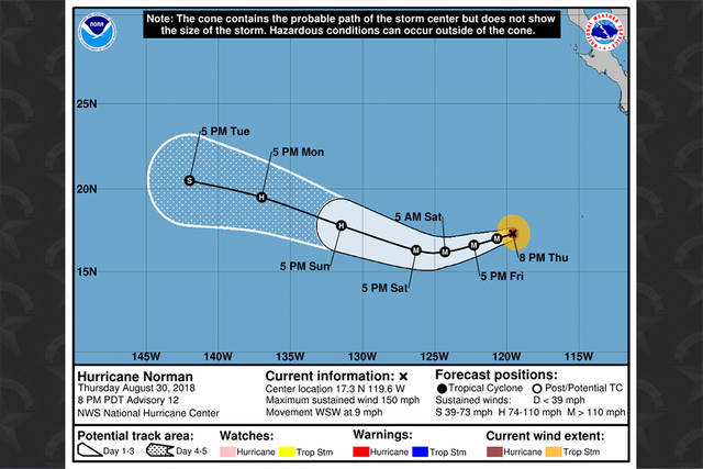
Hurricane Norman’s forecast track as of 5 p.m. HST today.
UPDATE: 5 p.m.
Norman remains a category 4 hurricane, moving toward the west-southwest near 9 mph.
At 5 p.m., Norman was located 2,325 miles east of Hilo and 2,510 miles east-southeast of Honolulu.
“Gradual weakening is anticipated, however, Norman is expected to remain a very powerful hurricane during the next few days,” forecasters said.
The National Hurricane Center said Norman is expected to turn toward the west and west-northwest over the weekend.
Maximum sustained winds remain near 150 mph with higher gusts. Hurricane-force winds extend outward up to 25 miles from the center and tropical-storm-force winds extend outward up to 80 miles.
Don't miss out on what's happening!
Stay in touch with breaking news, as it happens, conveniently in your email inbox. It's FREE!
11 a.m.
Maintaining its strength this morning, Hurricane Norman continued on track toward the Hawaiian Islands from the Eastern Pacific.
With maximum sustained winds of 150 mph and heading west at 8 mph, Norman was located about 2,375 miles east of Hilo at 11 a.m., according to the National Hurricane Center.
A west-southwestward motion is forecast to begin tonight and continue through Friday. However, a turn back toward the west and west-northwest is expected over the weekend.
Some strengthening is possible tonight and early Friday. Although gradual weakening is anticipated to begin by Friday night or Saturday. However, Norman is expected to remain a very powerful hurricane during the next few days.
Hurricane-force winds extend outward up to 25 miles from Norman’s center and tropical-storm-force winds extend outward up to 80 miles.
Closer to Hawaii, Hurricane Miriam strengthened slightly today Opens in a new tab as it continued to turn northward.
PREVIOUS COVERAGE
Although it’s still in the Eastern Pacific, Norman continued to grow in strength overnight and is now a major hurricane.
Packing maximum sustained winds of 150 mph, Norman was located about 2,424 miles east of Hilo and headed west at 8 mph at 5 a.m. today, according to the National Hurricane Center.
Norman is expected to continue on its current track today. However, it’s forecast to turn west-southwestward on Friday, followed by a turn back toward the west and west-northwest over the weekend.
Norman is already a strong Category 4 hurricane, but additional strengthening is forecast during the next 12 to 24 hours. Gradual weakening is anticipated to begin by Friday night or Saturday, however, Norman is expected to remain a very powerful hurricane during the next few days.
Hurricane-force winds extend outward up to 25 miles from Norman’s center and tropical-storm-force winds extend outward up to 90 miles.


