‘Catastrophic flooding’ occurring on Big Isle as Hurricane Lane plods northward

DAN NAKASO/DNAKASO@STARADVERTISER.COM
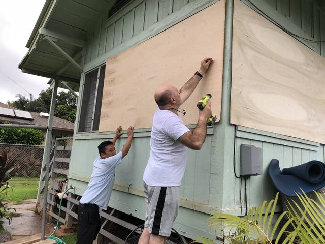
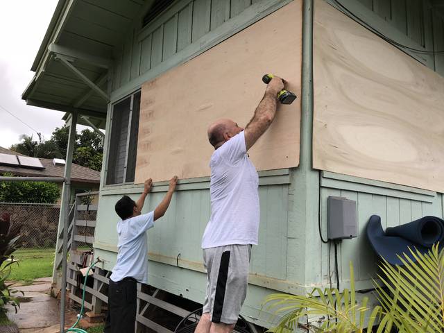
Rogelio Scarcelli (right) and his friend Yuri Laro apply plywood to the 3-bed, 1-bath home in Haleiwa owned by scarcelli’s daughter and son-in-law.

DAN NAKASO/DNAKASO@STARADVERTISER.COM
Rogelio Scarcelli (right) and his friend Yuri Laro apply plywood to the 3-bed, 1-bath home in Haleiwa owned by scarcelli’s daughter and son-in-law.


>> Click here for the latest news on Hurricane Lane
UPDATE: 2 a.m.
Hurricane Lane is still headed north toward Oahu as a major hurricane as “catastrophic flooding” is occurring on Hawaii island.
Located about 160 miles southwest of Kailua and 200 miles south of Honolulu, Lane was still packing maximum sustained winds of 120 mph and headed north at a leisurely 5 mph at 2 a.m., according to the Central Pacific Hurricane Center.
Although weather officials still expect Lane to turn west, that change in direction is not forecast to happen until Saturday. “The center of Lane will move over, or dangerously close to portions of the main Hawaiian Islands later today and tonight,” the CPHC said in a bulletin.
Hurricane-force winds extend outward up to 35 miles from Lane’s center and tropical-storm-force winds extend outward up to 125 miles.
Don't miss out on what's happening!
Stay in touch with breaking news, as it happens, conveniently in your email inbox. It's FREE!
Although Hawaii island is now under a tropical storm warning instead of a hurricane warning, the island is still under a flash flood warning until 6:45 a.m. with some areas having been inundated with over 20 inches of rain in the last 24 hours.
Rain gages in Hakalau registered 23.61 inches in the last 24 hours while Saddle Quarry registered 22.75 inches.
11 p.m.
Hurricane Lane continues to move north near 6 mph and has dumped nearly 2 feet of rain on the Big Island.
In the latest update, the Central Pacific Hurricane Center reported Lane moving 165 miles southwest of Kailua-Kona and 345 miles south of Honolulu.
Lane is still forecast to move dangerously close to portions of the Hawaiian Islands late Friday.
Maximum sustained winds are near 120 mph with higher gusts. Hurricane-force winds extend outward up to 35 miles from the center and tropical-storm-force winds extend outward up to 125 miles.
At 10:45 p.m., heavy rain was reported along the windward sections of the Big Island, with the heaviest rains focusing upslope of Hilo in the Wailuku River valley.
>> Star-Advertiser Hurricane Tracker
>> Some shopping malls closing early due to Hurricane Lane
>> Flood risk rises in East Hawaii as Hurricane Lane stalls
>> Major thoroughfares on Oahu, Big Isle, Kauai closing due to Lane
>> HECO expects Lane will prompt power outages
>> Airlines issue travel waivers for passengers
>> Last-minute shopping a challenge
>> Mayor says slow-moving storm could cause major problems
>> How to pack a disaster preparedness kit
VIDEO:
>> Pi‘ihonua Bridge in Kaumana hit with flooding from Hurricane Lane
>> Weather Channel hurricane expert has a message for residents of Hawaii
>> Hawaii residents stock up on supplies ahead of Hurricane Lane
PHOTOS:
>> Hurricane Lane causes flooding on Hawaii island
>> Hawaii residents prepare for arrival of Hurricane Lane Opens in a new tab
Evacuations and water rescues are in progress, including in the Reeds Island area of Hilo along the Wailuku River. “Water levels on the Wailuku River and Honolii Stream remain very high, with the level on the Wailuku River having risen about 7 feet between 6 p.m. and 10 p.m.,” weather officials said tonight.
Emergency crews rescued five California tourists from a home they were renting in Hilo after a nearby gulch overflowed and it flooded today.
Suzanne Demerais said a tiny waterfall and small stream flowed near the home when she first arrived with four of her friends from the Los Angeles area. But the stream turned into a torrent and the river rose rapidly over 24 hours. Hawaii County firefighters, who were in touch with the home’s owner, decided to evacuate the group before the water rose further. They floated the five out on their backs, Demerais said.
“It was quite an experience because we weren’t planning to have a hurricane during our vacation time,” Demerais said.
Forecasters say it will move close to or over portions of Hawaii’s main islands later tonight or Friday, bringing dangerous surf of 20 feet.
Extreme flooding continues to occur on the Big Island as the flash flood warning remains in effect.
Locations in the warning include but are not limited to Hilo, Naalehu, Paauilo, Waipio Valley, Orchidlands Estates, Kukuihaele, Hawi, Pepeekeo, Keaau, Honokaa, Ookala and Hawaiian Paradise Park.
9:30 p.m.
The flash flood warning for the Big Island has been extended until 12:45 a.m. Friday.
The National Weather Service repored heavy rain along the windward and southeast sections of the island at 9:15 p.m., with the heaviest rains focusing upslope of Hilo in the Wailuku River valley and along the slopes of Hamakua coast from Laupahoehoe to Honokaa.
The Hawaii County Civil Defense reports that evacuations are occurring in the Reeds Island area of Hilo along the Wailuku River. Water levels on the Wailuku River and Honolii Stream remain very high. The weather service reports that the level on the Wailuku River has risen about 5 feet between 6 p.m. and 9 p.m. tonight.
Saddle Road remains closed near the 10.5 mile marker above Hilo due to a landslide.
Locations in the warning include but are not limited to Hilo, Naalehu, Paauilo, Waipio Valley, Orchidlands Estates, Kukuihaele, Hawi, Pepeekeo, Keaau, Honokaa, Ookala and Hawaiian Paradise Park.
9 p.m.
The Hawaii Police Department and fire personnel are recommending residents of Reeds Island on Kaiulani Street in Hilo to evacuate their homes due to increased danger of severe flooding.
Public safety personnel are going house to house to inform them of the increasing threat. Those refusing to evacuate may not be able to be rescued by first responders should conditions continue to worsen. Kaiulani Street is closed to incoming traffic.
8 p.m.
Hurricane Lane remains a category 3 storm as it approaches the islands, moving north near 6 mph.
It was last located about 170 miles southwest of Kailua-Kona and 230 miles south of Honolulu.
A slow general northward motion is expected to continue through Friday, and a turn toward the west is anticipated Saturday and Sunday, the Central Pacific Hurricane Center said in its latest report.
Maximum sustained winds are near 120 mph with higher gusts. Hurricane-force winds extend outward up to 35 miles from the center and tropical-storm-force winds extend outward up to 125 miles.
The flash flood warning for the Big Island also remains in effect until 9:45 p.m.
At 8 p.m., radar indicated bands of heavy rain continuing to move into the windward and southeast sections of the island, with rainfall rates of 1 to 3 inches per hour. “The heaviest rainfall has been focused upslope from Hilo and along the Hamakua coast just north of Hilo during the past couple of hours,” the weather service said. Water levels on the Wailuku River and Honolii Stream are rising rapidly.
Flash flooding is ongoing across the warned area, with recent reports of road closures and water rescues. Saddle Road is closed near the 10.5 mile marker above Hilo due to a landslide, the Hawaii Police Department said tonight. Clean up crews are enroute.
Locations in the warning include but are not limited to Hilo, Naalehu, Paauilo, Waipio Valley, Orchidlands Estates, Kukuihaele, Hawi, Pepeekeo, Keaau, Honokaa, Ookala and Hawaiian Paradise Park.
6:30 p.m.
The National Weather Service has extended the flash flood warning for the Big Island until 9:45 p.m.
At 6:30 p.m., radar showed bands of heavy rain continuing to move into the windward and southeast sections of the island, with rainfall rates of 1 to 3 inches per hour.
Numerous road closures have been reported, and water rescues with homes flooded have been reported during the day. In addition, water levels on streams and rivers in the area remain very high.
Locations in the warning include but are not limited to Hilo, Naalehu, Paauilo, Waipio Valley, Orchidlands Estates, Kukuihaele, Hawi, Pepeekeo, Keaau, Honokaa, Ookala and Hawaiian Paradise Park.
5:40 p.m
“The weakening trend is underway,” Central Pacific Hurricane Center forecasters said in their 5 p.m. forecast discussion.
Hurricane had maximum sustained winds of 120 mph just before 5 p.m., moving north-northwest at 6 mph and was 180 miles southwest of Kailua-Kona and 240 miles south of Honolulu. Hurricane-force winds extend outward up to 35 miles from the center and tropical storm-force winds extend up to 125 miles.
Lane started the morning as a Category 4 hurricane, with 130 mph sustained winds and higher gusts, but began a weakening trend as the day progressed.
Forecasters expect that weakening to continue but caution that it is still a major hurricane capable of significant damage from flooding rains, high winds and strong storm surge.
“As the inner core continues to deteriorate, Lane will come increasingly under the influence of the low level easterlies and begin tracking westward,” they said. “However, the exact time when this will occur is still rather uncertain, and only a small delay in this decoupling could bring Lane farther north, with considerably worse conditions over the islands. Even if Lane remains along the forecast track, some significant impacts are expected.”
“The slow movement of Lane also greatly increases the threat for prolonged heavy rainfall and extreme rainfall totals. This is expected to lead to major, life-threatening flash flooding and landslides over all Hawaiian islands,” they continued. “Large and damaging surf can be expected along exposed shorelines, especially along south and west facing coasts, with localized storm surge exacerbating the impacts of a prolonged period of damaging surf. This could lead to severe beach erosion.”
By 5 p.m. Friday, Lane is expected to be about 120 miles south of Honolulu as a Category 2 storm with 100 mph winds.
5:20 p.m.
Emergency workers rescued five people from a flooded house on the Big Island as Hurricane Lane dumped heavy rains on the island.
Hawaii County Managing Director Wil Okabe says water gushed into the Hilo home today after a nearby gulch overflowed. He says they were not injured and were taken to a shelter.
Okabe also says the county used a helicopter to rescue two campers who were trapped overnight in Waipio Valley. The campers were not injured.
5 p.m.
Category 3 Hurricane Lane weakened slightly again this afternoon, now with maximum sustained winds of 120 mph before 5 p.m., forecasters said.
The storm was moving slowly north-northwest at 6 mph and was 180 miles southwest of Kailua-Kona and 240 miles south of Honolulu.
Some weakening is forecast during the next 48 hours, but Lane is expected to remain a hurricane as it draws closer to the islands, they said.
Hurricane-force winds extend outward up to 35 miles from the center and tropical storm-force winds extend up to 125 miles.
The hurricane warning for the Big Island has been changed to a tropical storm warning. Maui County and Oahu remain under a warning while Kauai County is under a hurricane watch.
3:30 p.m.
The National Weather Service has extended the flash flood warning for Big Island until 6:45 p.m. today.
At 3:16 p.m., radar showed a band of intense rain moving over Hilo with rates of 2 to 3 inches per hour. Hawaii County Civil Defense reported an ongoing water rescue at Kaiulani Street. A Skywarn spotter also reported a home being flooded at Kaumana in upper Hilo, the weather service said. Bands of heavy rain will continue to move over Hilo into tonight.
Locations in the warning include but are not limited to Hilo, Naalehu, Paauilo, Waipio Valley, Orchidland Estates, Hawi, Pepeekeo, Keaau, Honokaa, Hawaiian Paradise Park, Pahoa, Pahala, Laupahoehoe, and Mountain View.
2:15 p.m.
National Weather Service says Hurricane Lane has been downgraded to a Category 3 storm, with winds of 125 mph and moving west-northwest at a slow 6 mph.
At 2 p.m., Lane was about 260 miles south of Honolulu.
Category 3 hurricanes include winds from 111 to 129 mph and can cause major damage. Forecasters say the storm previously shifted course Thursday and is now moving closer to Hawaii.
National Weather Service meteorologist Melissa Dye told the Associated Press that some parts of the Big Island have received 20 inches of rain in the past 24 hours.
Lane was not projected to make a direct hit on the islands, but officials warned that even a lesser blow could do significant harm. Some areas could see up to 30 inches of rain.
A flash flood warning has been posted for the Big Island until 3:45 p.m. today and may be extended.
At 12:26 p.m., heavy rain was moving onshore from the southeast, with rain rates at 1 to 2 inches per hour, weather officials said. Civil Defense reported that Highway 270 remains closed near mile marker 24. Kaalaiki Road in the Kau District has also been closed.
Heavy rain will continue to move over the island through the rest of the afternoon and possibly longer. Locations in the warning include but are not limited to Hilo, Naalehu, Paauilo, Waipio Valley, Orchidland Estates, Hawi, Pepeekeo, Keaau, Honokaa, Hawaiian Paradise Park, Pahoa, Pahala, Laupahoehoe, and Mountain View.
1:50 p.m.
The City and County of Honolulu plans to activate the island-wide outdoor siren warning system at 4 p.m. today as Hurricane Lane approaches the island.
City officials said this is to alert the public to the potential of severe flooding from Hurricane Lane, and the possibility of damaging winds, and will coincide with an Emergency Alert System message.
The Attention Alert steady tone will sound for three minutes on Oahu only, as each county controls their own sirens.
At 4 p.m. when the sirens sound, service on TheBus will be free to all patrons, including transportation to the 20 evacuation shelters throughout Oahu. This is being done now so that anyone who wants to get to a shelter can do so safely while there is still daylight. As of noon today, 17 of the city’s 20 shelters reported a total of 350 people.
If you live next to a waterway or the ocean and witness rising water, don’t hesitate – evacuate and get to higher ground, officials said. Call 911 to report flooding conditions, or 768-CITY. In addition, be aware of the potential of landslides and rock falls if you live next to a cliff or ridge or valley.
“We want to be sure everyone on Oahu is made fully aware of the threat that Hurricane Lane poses and takes it seriously,” said Mayor Caldwell. “We are providing advance notice that sirens will be activated on Oahu to inform everyone that we remain under a hurricane warning. This is being done after the latest forecast by the Central Pacific Hurricane Center shows that Hurricane Lane continues to move slowly past the Hawaiian islands. Therefore, we are looking at a significant rain event since the storm is extremely wide and holds a lot of moisture. People need to be aware of dangerous and potentially life-threatening flooding from overflowing streams and coastal flooding from storm surge generated by Hurricane Lane.”
Here is the text of the Emergency Alert System message that will be broadcast along with the outdoor sirens: “This is an emergency management message. A hurricane warning is in effect. Extremely dangerous wind and flooding may occur tonight. Flooding may occur in coastal areas, near streams, and low lying areas. If your home is threatened, leave the area. The Bus will transport people to shelter and no fare is required. Beaches and beach parks are closed. Leave immediately. Stay tuned to TV, radio, and official social media.”
Rain, rain, and more rain! Animation of forecast precipitation totals Wed-Sat afternoon. Flooding & landslides a big concern with #HurricaneLane. #HIwx pic.twitter.com/HQCnyBkH40
— NWSHonolulu (@NWSHonolulu) August 23, 2018
Noon
A flash flood warning has been posted for the island of Maui through 2:45 p.m.
Radar showed heavy rain continuing over East Maui from Keanae to Kipahulu. Maui County emergency managers reported that Wainapanapa Road, Ulaino Road, and Waikoloa Road near Hana are closed.
Kawaipapa Stream is also running very high. Rainfall over East Maui will continue for several more hours.
Locations in the warning include, but are not limited to, Haiku-Pauwela, Huelo, Pauwela, Kipahulu, Nahiku, Kaupo, Hana, Makawao and Kula.
11 a.m.
Although it’s expected to turn north later today and weaken over the next two days, Hurricane Lane is still on the same heading at the same speed and strength as it’s been since 5 a.m.
Located about 200 miles south-southwest of Kailua-Kona and 275 miles south of Honolulu, Lane clocked in with winds of 130 mph, headed northwest at 7 mph at 11 a.m., according to the Central Pacific Hurricane Center.
Hurricane-force winds extend outward up to 35 miles from Lane’s center and tropical-storm-force winds extend outward up to 140 miles.
A slow northward motion is expected to begin today, weather officials said. A turn toward the west is expected Saturday and Sunday, with an increase in forward speed. On the forecast track, the center of Lane will move over, or dangerously close to portions of the main Hawaiian islands later today through Friday.
8:15 a.m.
Although its wind speed, forward speed and heading have not changed since 5 a.m., Hurricane Lane is now closer to both Honolulu and Kailua-Kona.
Located about 205 miles southwest of Kailua-Kona and 290 miles south of Honolulu, Lane was moving northwest at 7 mph at 8 a.m., according to the Central Pacific Hurricane Center.
Hurricane-force winds extend outward up to 35 miles from Lane’s center and tropical-storm-force winds extend outward up to 140 miles.
7:40 a.m.
The Federal Emergency Management Agency is holding a joint press conference with other federal agencies detailing their response to Hurricane Lane.
7 a.m.
A flash flood warning has been extended for Hawaii island through 9:45 a.m.
At 6:27 a.m., radar and rain gages showed heavy rain continuing to soak the windward Kohala slopes to South Point. There are multiple road closures due to flooding, including Highway 19 near Honomu.
More rain is approaching from the southeast. Motorists are advised to avoid unnecessary travel.
Locations in the warning include, but are not limited to, Hilo, Naalehu, Paauilo, Waipio Valley, Orchidland Estates, Kukuihaele, Hawi, Pepeekeo, Keaau, Honokaa, Hawaiian Paradise Park, Pahoa and Mountain View.
A high surf warning remains in effect for all islands through Friday.
Surf up to 25 is forecast along the Kau and Puna coasts while Kailua-Kona can expect surf up to 12 feet. The south shores of the other islands will see surf up t 10 feet today, rising to 15 feet tonight and 20 feet on Friday.
“Stay well away from the shoreline,” weather officials advised. “Large breaking surf, and dangerous currents make entering the water extremely hazardous. Anyone entering the water could face death.”
PREVIOUS COVERAGE
Hurricane Lane continued to weaken slightly overnight but is still moving closer to the islands.
Clocking in with maximum sustained winds of 130 mph and moving northwest at 7 mph, Lane was located about 210 miles south-southwest of Kailua-Kona and 305 miles south of Honolulu at 5 a.m., according to the Central Pacific Hurricane Center.
Hurricane-force winds extend outward up to 35 miles from Lane’s center and tropical-storm-force winds extend outward up to 140 miles.
A hurricane warning is in effect for Oahu, Maui County and Hawaii County. A hurricane watch is in effect for Kauai County.
A flash flood warning remains in effect for Hawaii County through 6:45 a.m. today.
At 5:01 a.m., Hawaii County Civil Defense reported ongoing flash flooding in Waipio Valley. Highway 19 is closed in both directions due to a landslide near Honomu and there are other road closures due to flash flooding, including Bayfront Highway in Hilo.
Water levels for Honolii stream, Wailuku River and Kawainui stream remain very high. Numerous streams and drainages in the area around Hilo and northward up the Hamakua coast are likely overflowing, causing very dangerous conditions, the National Weather Service said in a bulletin.
Radar and rain gauges show persistent rainfall rates of 1 to 2 inches per hour as outer rain bands from Hurricane Lane continue to stream into windward sections of the Big Island. Flash flooding is already occurring and is likely to become more severe and widespread as the heavy rains persist, weather officials said.
The Associated Press contributed to this report.


