Residents of Lower Puna who do not evacuate today risk being stranded


DENNIS ODA / DODA@STARADVERTISER.COM
Night view of lava erupting from fissure 8, Thursday, from the Leilani Community Association playground in Leilani Estates.

DENNIS ODA / DODA@STARADVERTISER.COM
A national guardsman took noxious gas readings on Highway 132 Thursday.
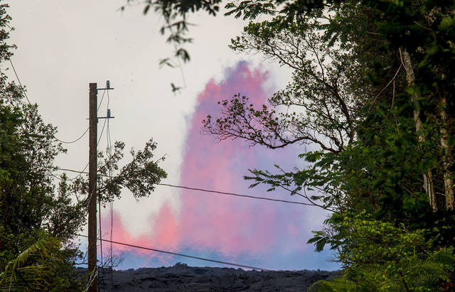
DENNIS ODA / DODA@STARADVERTISER.COM
A large fountain of lava from fissure 8 was seen, Tuesday, from the end of Luana St. in Leilani Estates in Puna.
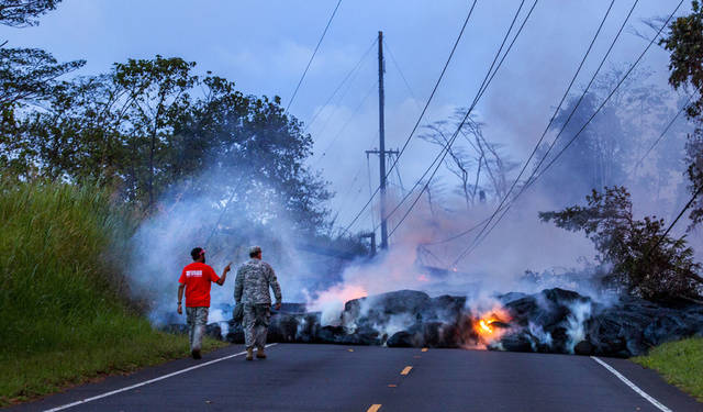
DENNIS ODA / DODA@STARADVERTISER.COM
Lava from fissure 8 flowed over Pohoiki Road, Monday, between Leilani Estates and the Puna geothermal plant. A USGS scientist and national guardsman walked toward the flow to check the air quality.
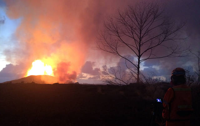
HAWAIIAN VOLCANO OBSERVATORY / USGS
Crews made visual observations of activity at fissure 8 around 5:30 a.m. Thursday. Fountain heights Thursday morning reached 230 to 260 feet above ground level. The fountaining fed a lava flow that was moving to the northeast along Highway 132 into the area of Noni Farms Road.
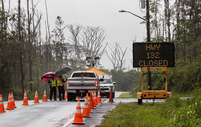
DENNIS ODA / DODA@STARADVERTISER.COM
Highway 132 near Pohoiki Road past Pahoa was closed Tuesday morning due to lava.
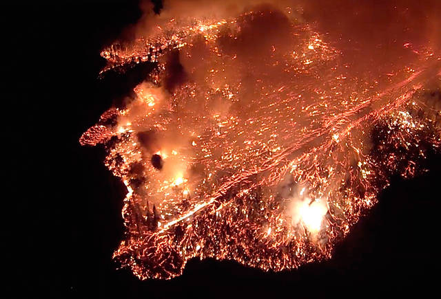
U.S. GEOLOGICAL SURVEY
An outbreak of Pahoehoe lava moved rapidly north down Luana Street, Wednesday, into a portion of Leilani Estates as searchers attempted to evacuate a resident who was about to be stranded by the fast-moving flow, near Pahoa.
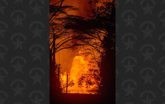
DENNIS ODA / DODA@STARADVERTISER.COM
Night view, Wednesday, of the lava eruption from fissure 8 from Luana St. in Leilani Estates.


UPDATE: 7:30 a.m.
A fissure 8 lava flow heading has been progressively accelerating and was less than a mile from Four Corners at 6:30 a.m.
Hawaiian Volcano Observatory officials did a flyover at 6:30 a.m. and said the lava flow was 0.84 miles above Four Corners and had moved 100 yards in one hour.
>> Allegedly intoxicated man arrested after crashing into hardened lava
>> Arrests possible for Leilani Estates holdouts
>> Leilani Estates lava might not be part of the eruption that began in 1983
>> Kau residents irritated by ashfall from volcano
>> California man cited for flying drone in eruption no-fly zone
>> Pahoa man, 61, charged with armed robbery after shots fired in Leilani Estates video
>> Lava scientists’ drone guides lost resident through jungle
>> Puna man ‘just wanted to live’ after nearly losing leg to lava bomb
RELATED PHOTOS AND VIDEOS
>> Live webcams from Hawaii island
>> Pyroclasts inundate Leilani Estates as lava continues to flow, May 31
>> Hawaii Army National Guard Major Jeff Hickman provides an update, May 31
>> Leilani Estates residents talk about evacuating as lava advances, May 31
>> Hawaii Fire Department tracks lava from the air, May 30
>> Aerial view of lava flow in Leilani Estates, May 29
>> No break over holiday weekend for Kilauea, May 28
COMPLETE KILAUEA COVERAGE
>> Star-Advertiser volcano coverage
>> Kilauea Volcano YouTube playlist
Don't miss out on what's happening!
Stay in touch with breaking news, as it happens, conveniently in your email inbox. It's FREE!
6:45 a.m.
Hawaii County Civil Defense officials remind residents of Leilani Estates that they have until noon today to leave the mandatory evacuation area, which includes areas east of Pomaikai Street in their subdivision.
The agency said that people remaining in the evacuation area after the deadline do so at their own risk and with the possibility that emergency responders may not be able to assist them.
5 a.m.
The fissure 8 lava flow continues its advance toward Four Corners, though the pace of the flow increased slightly earlier this morning.
Now approximately 1 mile above Four Corners, the flow moved 50 yards between 2:43 a.m. and 3:43 a.m. after having moved 65 yards between 11:53 p.m. Thursday and 1:53 a.m. today, according to the Hawaiian Volcano Observatory.
Fissure 8 also continues to produce large lava fountains up to 260 feet. A small spatter cone is forming on the downwind side of the fountain and was about 100 feet high as of 11 p.m. Thursday, the HVO said. The fountains are feeding a major flow field heading north through Leilani Estates and then northeast along the course of Highway 132.
THURSDAY, MAY 31
10 p.m.
The U.S. Geological Survey tweeted that as of 9:53 p.m., the Fissure 8 lava flow front had advanced across agricultural land to within 1.1 miles of Four Corners (Highway 132/137 intersection).
7 p.m.
Vigorous lava eruptions continue in Leilani Estates and Lanipuna Gardens, Hawaii County of Civil Defense reports.
Fissure 8 produced fountains that reached heights up to 260 feet today and a small spatter cone is forming on the downwind side of the fountain that is approximately 100 feet high.
Breaches in the channel formed by the Fissure 8 flow can happen without notice and develop rapid moving flows.
Hawaii Fire Department has evacuated residents in homes along Papaya Farms Road and Noni Farms Road. Any residents remaining should evacuate now.
All residents of Vacationland and Kapoho Beach Lots are also advised to evacuate and complete their evacuation by 6 p.m. Friday or risk the possibility of being isolated.
Mayor Kim has issued a mandatory evacuation order for parts of Leilani Estates. The following policies are in effect:
>> Mandatory evacuation is for areas east of Pomaikai Street in Leilani Estates.
>> Residents have until 12 p.m. Friday to evacuate the mandatory evacuation area.
>> Persons remaining in the mandatory evacuation area do so at their own risk with the knowledge that emergency responders may not be able to respond.
Map of Mandatory Evacuation Order by Honolulu Star-Advertiser on Scribd
Kilauea Lower East Rift Zone Fissures and Flows, May 31 by Honolulu Star-Advertiser on Scribd
Map details shown here are accurate as of the date/time noted. Shaded purple areas indicate lava flows erupted in 1840, 1955, 1960, and 2014-2015. (see large map Opens in a new tab)
4 p.m.
Hawaii Electric Light is working to maintain power for Lower Puna communities that have been affected by lava flows.
About 800 customers in Leilani Estates, Lanipuna Gardens and Kapoho are experiencing extended power outages due to the destruction of poles, lines and equipment.
On Monday, crews performed switching operations to reroute power to customers in Lower Puna before the lava flow crossed Highway 132.
Today, crews connected two transmission lines near the Ainaloa subdivision to make the electrical grid more resilient if a problem were to occur with other transmission lines on the grid.
Hawaii Electric Light reports that it still has sufficient generation to meet the island’s electricity needs, despite the loss of independent power producer Puna Geothermal Venture on May 3.
11:10 a.m.
Potential traffic delays are once again in store as heavy machinery is transported from the vicinity of Waikoloa Road to Kalapana for use in preparation of Lower Puna evacuation routes today, according to state Department of Transportation officials.
Intermittent road closures are scheduled from about noon to 5 p.m. along the Waikoloa roadway (Queen Kaahumanu Highway to Mamalahoa Highway 190), Saddle Road, Puainako Street, Highway 11 and Highway 130.
Motorists are advised to drive with caution and expect delays while escorts temporarily block the roadway in certain areas to allow for the large transport trucks to safely transverse this route to Kalapana.
On Tuesday, heavy machinery was also transported from Waikoloa to Kalapana for use in preparation of Lower Puna evacuation routes.
Questions can be directed to Hawaii District Engineer Donald Smith at 933-8866.
10:40 a.m.
Although lava from several fissures continues to move through Leilani Estates, Lanipuna Gardens and toward the Kapoho area, fissure 8 is producing the most active flow with a channel that could overflow at any time, Hawaii County Civil Defense said.
A lava flow in the area of Noni Farms Road is heading toward the Waawaa and Four Corners areas, according to the Hawaii County Fire Department.
Kilauea continues to belch volcanic ash, which is being carried by tradewinds toward the southwest. The Kau district and Highway 11 southwest of the town of Volcano are particularly affected. This includes the communities of Pahala, Wood Valley, Naalehu and Ocean View, the National Weather Service said.
Near Leilani Estates, Pele’s hair and other lightweight volcanic glass continue to be thrown off by high fountaining fissures.
9:45 a.m.
Hawaii County Mayor Harry Kim has signed a mandatory evacuation order covering about half of the Leilani Estates subdivision and is officially warning people who remain behind that police and firefighters might not respond if they get into trouble.
The Leilani Estates subdivision was officially evacuated shortly after the May 3 eruption of Kilauea Volcano began, but county Civil Defense officials have been allowing residents back into the subdivision to retrieve belongings and check on their homes.
However, some residents have been returning to their homes in the evenings and sleeping there, which has become increasingly dangerous in areas where fissures are spewing lava.
Kim’s proclamation, which is effective at noon today, covers the area east of Pomaikai Street, a description that includes more than half of the subdivision.
The proclamation states that people who ignore the evacuation order and remain in the area east of Pomaikai “do so at their own risk with the knowledge that emergency responders may not respond.”
PREVIOUS COVERAGE
HILO >> The number of people seeking emergency shelter after escaping from lava flows in Lower Puna hit a new high of 409 today in the wake of evacuations of two additional subdivisions earlier this week, county officials said.
The county reported 351 people were being sheltered at the Pahoa Community Center this morning, and another 49 were being housed at the Keaau Community Center. Nine more evacuees were being sheltered at a facility operated by Sure Foundation Church in Keaau.
Authorities launched an emergency evacuation of Kapoho Beach Lots and the Vacationland subdivision in the Kapoho area early Wednesday morning, and the county is urging residents of the sparsely populated Waawaa area along the Lower Puna coastline to evacuate as well.
Snyder said Hawaii Island Mayor Harry Kim noted during a Civil Defense briefing this morning that “we have a tremendous housing problem on our hands.”
Lava from fissure 8 in Leilani Estates has continued its advance toward the last evacuation route out of the Kapoho area, and edged forward by about 900 yards overnight, according to a county spokeswoman.
That lava flow this morning was about 2.1 miles from the “Four Corners” intersection of Highway 132 and the coastal Highway 137, and is moving forward at a rate of about 80 yards per hour, according to scientists with the U.S. Geological Survey.
But that could change quickly. County spokeswoman Janet Snyder said the lava from fissure 8 has formed an above-ground channel, and “8 is still fountaining and very active, the channel is very full of lava.”
“The channel may overflow or breach at any time, people really should be aware, especially the ones who are going really close to it,” Snyder said.
Construction began Thursday morning on the effort to reopen Chain of Craters Road to Hawai‘i Volcanoes National Park, and crews graded about 700 feet of the cooled lava flow that has been blocking the road near the Kalapana coastline.
There are two bulldozers on the job site, and the state predicts the debris will be cleared off the road by Saturday. The road will be used as an emergency evacuation route if lava severs Highway 130 between Pahoa and Kalapana.


