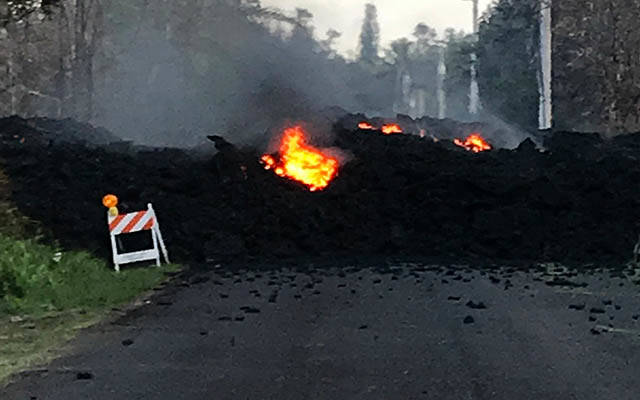
Overnight, earthquakes and lava become the new norm on Hawaii island

MICK KALBER/ SPECIAL TO THE HONOLULU STAR-ADVERTISER
A screen grab from a video shot by Mick Kalber shows lava leaping into the air from a fissure in the neighborhood of Leilani Estates on the Big Island of Hawaii.

USGS
This map provided by the US Geological Survey shows the locations of fissures on the East Rift Zone of Kilauea zone.

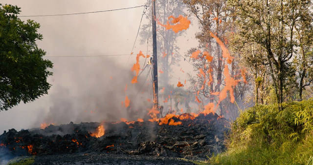
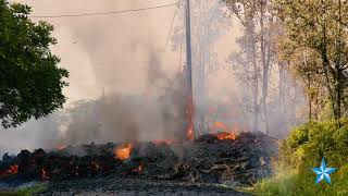
SHANE TURPIN/SEELAVA.COM VIA ASSOCIATED PRESS
Results of the eruption from Kilauea Volcano on Hawaii island today. The eruption sent molten lava through forests and bubbling up from paved streets and forced the evacuation of about 1,800 people who were still out of their homes today after Thursday’s eruption.
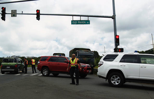
JAMM AQUINO / JAQUINO@STARADVERTISER.COM
Hawaii County police closed Highway 130 southbound near Puna today.
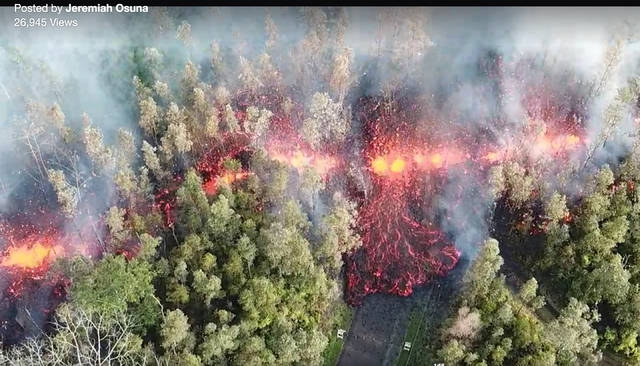
COURTESY OF JEREMIAH OSUNA
This screenshot is taken from a drone video taken of the lava flow today on Hawaii Island.
COURTESY HAWAII ELECTRIC LIGHT
Lava on Mohala Street in Leiliani Estates.
U.S. GEOLOGICAL SURVEY
A magnitude 6.9 earthquake struck the southern flank of Kilauea Volcano at 12:33 p.m. today.
PACIFIC TSUNAMI WARNING CENTER
An earthquake with a preliminary magnitude of 5.3 struck the south flank of Kilauea Volcano this morning.
COURTESY COUNTY OF HAWAII
Due to persistently unstable volcanic activity and the possibility of a new eruption, park officials temporarily closed Naulu Trail, parts of Napau Trail and adjacent wilderness in Kilauea Volcano’s East Rift Zone for public safety today.
COURTESY JANICE WEI
At 10:30 a.m. today, ground shaking from a preliminary magnitude-5.0 earthquake south of Puu Oo caused rockfalls and possibly additional collapse into the Puu Oo crater on Kīlauea Volcano’s east rift zone. A short-lived plume of ash produced by this event lofted skyward and dissipated as it drifted southwest from Puu Oo.
COURTESY COUNTY OF HAWAII
Hawaii County Civil Defense is on high alert on a 24-hour basis for the possibility of a volcanic eruption in the lower Puna area. All areas bordering the East Rift Zone are at high risk for eruption activities.
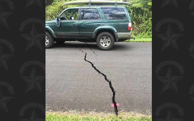
COURTESY DAVID MOORE
A crack appears on Kauhali Street, one block from Mohala Street.
PAHOA, Hawaii >> In the span of less than 24 hours, Hawaii island shook from the state’s strongest earthquake since 1975, evacuated roughly 1,800 people from lower Puna, and witnessed six new Kilauea volcano lava fissures burn into the small rural community of Leilani Estates.
The volcano, which had been threatening a new lava outbreak for days, opened up the first fissure shortly before 5 p.m. Thursday in the eastern end of the subdivision. The first outbreak was short-lived, lasting only a few hours and causing no known structure damage.
But by Friday afternoon there were at least six active fissures in the community, destroying a home and two other buildings, sending dangerous gas into the air, and forcing the evacuation of the entire subdivision.
Further, the ground shook steadily throughout the last two days, with hundreds of tremors of magnitude 2.5 or higher, with the strongest quake Opens in a new tab measuring magnitude 6.9 at 12:32 p.m. and centered in Leilani Estates, followed by countless aftershocks. The largest quake knocked out power to thousands, caused slight sea-level fluctuations and scared residents throughout the islands. It did not generate a tsunami.
“Things started shaking side to side. That was huge, the longest I ever felt,” said Hilo resident Bobbie Stivers-Apiki.
Hilo Hawaiian Hotel bellman Alan Shinkai said he was in the elevator during the quake. “I wanted to reach the ground as fast as possible,” he said.
Don't miss out on what's happening!
Stay in touch with breaking news, as it happens, conveniently in your email inbox. It's FREE!
For more volcano coverage, visit https://808ne.ws/2FIMk5c Opens in a new tab
For additional photos, visit https://808ne.ws/2HPRl22 Opens in a new tab
Timeline of earthquakes and eruption of Kilauea on Hawaii island Opens in a new tab
VIDEOS
USGS footage of fissure in Leilani Estates Opens in a new tab
Facebook Live: “There could be another eruption” Opens in a new tab
Lava flow in Leilani Estates Opens in a new tab
Hawaii Police shut down road after eruption Opens in a new tab
Crack opens in road, lava flows in Leilani Estates Opens in a new tab
Puu Oo vent empties Opens in a new tab
The seismic and volcanic hyperactivity led to numerous closures and disruptions across the Big Island.
>> All residents in Leilani Estates and Lanipuna Gardens Subdivisions are required to evacuate.
>> The American Red Cross opened two shelters Opens in a new tab at the Pahoa and Keaau community centers. The Pahoa center had 200 residents by this afternoon while the Keaau center had 2 residents.
>> The Hawaii Volcanoes National Park was closed in the afternoon “for the safety of our visitors and employees” after the violent shaking from the 12:32 p.m. quake. Park officials evacuated 2,600 visitors, relocated guests at Volcano House hotel and Kilauea Military Camp, and sent home all non-emergency park employees. “Safety is our main priority at Hawai‘i Volcanoes National Park, and it is currently not safe to be here,” said Park Superintendent Cindy Orlando. “We will monitor the situation closely, and reopen when it is safe to do so.”
Park officials said the quake triggered rock slides on trails, crater walls, and along Chain of Craters Road, while an earlier magnitude-5.4 quake caused a coastal cliff to collapse into the ocean near the Holei Sea Arch. The quake also caused narrow fissures in the ground at an overlook near Jaggar Museum, and rock falls into the lava lake within Halemaumau Crater, sending up dark clouds of ash.
>>The largest quake cut power to 14,400 Hawaii Electric Light Co. customers. By 2:25 p.m., service had been restored to all customers, the company reported.
>> Kua O Ka La Charter School, Hawaii Academy of Arts and Science, Keonepoko Elementary and Pahoa High, Intermediate, and Elementary were closed today.
>> About 70 members of the Hawaii National Guard were deployed to the island Opens in a new tabto help with evacuation and other efforts. Those citizen-soldiers include six from the Guard’s 93rd Weapons of Mass Destruction Civil Support Team who will help the county with air quality tests. Hawaii National Guard spokesman Lt. Col. Charles Anthony said the team will bring equipment to help detect sulfur dioxide in Puna and provide air samples to the county.
Hawaii Fire Department reports extremely high levels of dangerous sulfur dioxide gas Opens in a new tab detected in the evacuation area. Elderly, young, and people with respiratory issues need to comply with the mandatory evacuation order and leave the area.
The Federal Aviation Administration issued temporary flight restrictions for the area above lower Puna until 11:59 p.m. Monday, due to the volcanic activity. The restrictions cover a five-nautical-miles radius of Pahoa, from the surface up to 3,000 feet above sea level. No pilots may operate an aircraft — including drones — in the area. Relief aircraft operations under the direction of the Hawaii Emergency Management Agency are authorized in the airspace.
>> The county Department of Water Supply issued an emergency water restriction for Leilani Estates, Nanawale Estates, Kapoho and Lanipuna Gardens, telling all water customers to immediately restrict water use to health and safety needs only.
>> On Thursday, Puna Geothermal Venture operations have shut down indefinitely until further notice. County officials said the facility is secure.
All the volcanic activity in Puna — and its dramatic images — have grabbed the attention of national and international media, prompting the Hawaii Tourism Authority to remind the traveling public Opens in a new tabthat most of the action is in a remote, sparsely populated area, and that most of the state is unaffected by earthquakes and molten lava.
George D. Szigeti, HTA’s president and chief executive, reassured travelers that flights haven’t been affected by the Kilauea volcano and the “area where lava is coming to the surface is very far from resort areas throughout the Hawaiian Islands where visitor accommodations are located.”
Gov. David Ige said in a statement, “We have heard from people around the world concerned about Hawaii’s welfare and want to reassure everyone that this is limited to a remote region on the slopes of Kilauea volcano. Everywhere else in the Hawaiian islands is not affected.”
Still, the quakes and flowing lava has unnerved many on the Big Isle Opens in a new tab.
State Sen. Russell Ruderman, of Keaau, said items were falling off the shelf while he was at Island Naturals, his Hilo natural food store, when the magnitude-6.9 quake struck.
“This last one was scary,” he said, adding that he lived in San Francisco for 10 years and experienced some there. “It starts rocking and keeps on going. It’s very frightening. We’re rattled.”
Evacuated Puna residents Henry and Stella Caleo, 64, said they don’t know if their home would still be standing.
“We don’t know anything,” Stella Caleo said. “We don’t know if we’re going to lose our house. We know nothing.”
The uncertainty extends to what Kilauea volcano will do next.
Late this afternoon, Hawaii County Civil Defense officials said that active volcanic vents continue on Makamae, Kaupili and Mohala streets, and near the intersection of Leilani Avenue and Kahukai Road.
They warn of “extremely dangerous conditions” due to sulfur dioxide in the evacuation area. “The high levels detected are an immediate threat to life for all who become exposed. First responders may not be able to come to the aid of residents who refuse to evacuate,” they said.
They also caution that more lava vents and more powerful earthquakes are possible in the days and weeks ahead.
———
For more information: http://www.hawaiicounty.gov/active-alerts Opens in a new tab
———
Honolulu Star-Advertiser reporters Dan Nakaso, Tim Hurley, Rosemarie Bernardo, William Cole, Nina Wu, and Allison Schaefers contributed to this report.


